 Old Cumbria Gazetteer
 |
 |
|
|
| Westmorland: threapland 6 | |||
| Disputed Ground | |||
| locality:- | Pancake | ||
| civil parish:- | Kaber (formerly Westmorland) | ||
| county:- | Cumbria | ||
| locality type:- | threapland | ||
| locality type:- | county boundary | ||
| coordinates:- | NY883066 (etc) | ||
| 1Km square:- | NY8806 | ||
| 10Km square:- | NY80 | ||
| county:- | North Yorkshire | ||
|
|
|||
| evidence:- | old map:- Greenwood 1834 |
||
| source data:- | Map, hand coloured engraving, Map of the County of Westmorland,
scale about 1 inch to 1 mile, by C and J Greenwood, published by
George Pringle jnr, 70 Queen Street, Cheapside, London, 1824.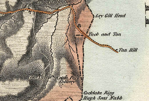 GRW5Th06.jpg two boundaries item:- Armitt Library : A1827 Image © see bottom of page |
||
|
|
|||
| evidence:- | old map:- Bartholomew 1940s |
||
| source data:- | Map, colour lithograph, Bartholomew's Revised Half Inch
Contoured Maps, sheet 35, Teesdale, scale about 2 miles to 1
inch, by John Bartholomew and Sons, The Edinburgh Geographical
Institute, Duncan Street, Edinburgh, Lothian, Scotland, 1952.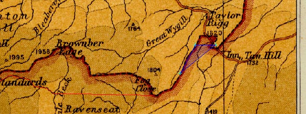 BA22Th06.jpg item:- JandMN : 828.35 Image © see bottom of page |
||
|
|
|||
| mapping:- | |||
|
|
|||
| mapping:- |  Tackan Tan, Kaber boundary stone, Kaber (4) boundary stone, Kaber (5) Tackan Tan, Kaber boundary stone, Kaber (4) boundary stone, Kaber (5)[boundary stone, Kaber (6)] |
||
|
|
|||
Lakes Guides menu.