 Old Cumbria Gazetteer
 |
 |
|
| mill, Skelwith Bridge (2) | ||
| locality:- | Skelwith Bridge | |
| civil parish:- | Lakes (formerly Westmorland) | |
| county:- | Cumbria | |
| locality type:- | mill | |
| locality type:- | water mill | |
| locality type:- | bobbin mill | |
| coordinates:- | NY34300342 (?) | |
| 1Km square:- | NY3403 | |
| 10Km square:- | NY30 | |
|
|
||
| evidence:- | old map:- OS County Series (Wmd 26 9) |
|
| source data:- | Maps, County Series maps of Great Britain, scales 6 and 25
inches to 1 mile, published by the Ordnance Survey, Southampton,
Hampshire, from about 1863 to 1948. "Bobbin Mill" |
|
|
|
||
| evidence:- | old photograph:- Bell 1880s-1940s item:- circular saw; saw; barn |
|
| source data:- | Photograph, black and white, bobbin mill at Skelwith Bridge, Westmorland, by Herbert
Bell, Ambleside, Westmorland, 1890s.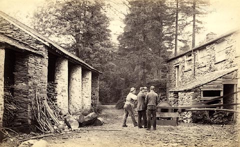 click to enlarge click to enlargeHB0415.jpg internegative at lower right:- "H. Bell." item:- Armitt Library : ALPS69 Image © see bottom of page |
|
|
|
||
 Lakes Guides menu.