 Old Cumbria Gazetteer
 |
 |
|
| Kinniside | ||
| civil parish:- | Ennerdale and Kinniside (formerly Cumberland) | |
| county:- | Cumbria | |
| locality type:- | locality | |
| coordinates:- | NY050155 (etc) | |
| 1Km square:- | NY0515 | |
| 10Km square:- | NY01 | |
| SummaryText:- | undefined | |
|
|
||
| evidence:- | old map:- Donald 1774 (Cmd) placename:- Kinniside |
|
| source data:- | Map, hand coloured engraving, 3x2 sheets, The County of Cumberland, scale about 1
inch to 1 mile, by Thomas Donald, engraved and published by Joseph Hodskinson, 29
Arundel Street, Strand, London, 1774.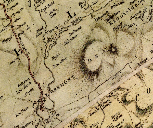 D4NY01SW.jpg "Kinniside" area item:- Carlisle Library : Map 2 Image © Carlisle Library |
|
|
|
||
| evidence:- | descriptive text:- West 1778 (11th edn 1821) placename:- Kinnyside |
|
| source data:- | Guide book, A Guide to the Lakes, by Thomas West, published by
William Pennington, Kendal, Cumbria once Westmorland, and in
London, 1778 to 1821. goto source goto sourceAccount of Ennerdale, late 18th century Page 295:- "Within these few years, several visitors of the lakes extend their tour, by taking in Whitehaven, and proceeding from thence, by Cleator and Kinnyside, to Ennerdale Bridge; ..." |
|
|
|
||
| evidence:- | old map:- Otley 1818 placename:- Kinnyside |
|
| source data:- | Map, uncoloured engraving, The District of the Lakes,
Cumberland, Westmorland, and Lancashire, scale about 4 miles to
1 inch, by Jonathan Otley, 1818, engraved by J and G Menzies,
Edinburgh, Scotland, published by Jonathan Otley, Keswick,
Cumberland, et al, 1833.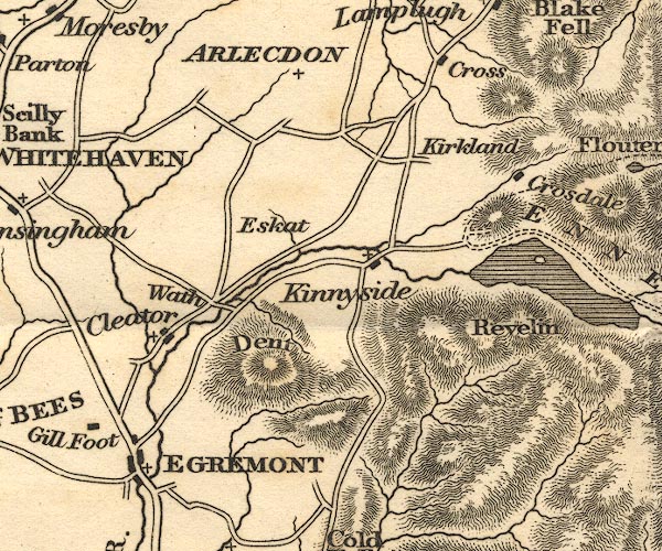 OT02NY01.jpg item:- JandMN : 48.1 Image © see bottom of page |
|
|
|
||
Lakes Guides menu.