 Old Cumbria Gazetteer
 |
 |
|
| included in:- |
 High Sadgill, Longsleddale High Sadgill, Longsleddale |
|
| High Sadgill, Longsleddale: Corn Rent Act 1836 | ||
| evidence:- | perhaps tithe schedule:- Kendal Corn Rent Act 1836 placename:- Sad Gill |
|
| source data:- | Tithe map, Plan of part of the Township of Longsleddale, Westmorland, made regarding
the Kendal Corn Rent Act, ie a tithe award map, scale about 20 inches to 1 mile, Kendal,
Westmorland, 1836. Schedule, each row gives:- Field no. / Tenant's name / Close ie Field name / Type of culture / Area, acres Owned by John Anson, tenanted by himself; Sad Gill. "/ / Anson John" "/ 405a / Himself ½ / Green Road &c / Pas. / 0 140" "/ 426 / Do / Hote Green / Ar &Mea / 1 220" "/ 427 / Do / Newlands / Pas / 2 140" "/ 428 / Do / Ing / Mea / 2 740" "/ 429 / Do / [Muglands] / Ar &Mea / 2 535" "/ 430 / Do / Rough Craggs / Pas / 89 780" "/ 431 / Do / Bank / Pas / 24 100" "/ 432 / Do / Bank Foot / Pas / 5 825" "/ 433 / Do / Wood / Pas &Wood / 7 515" "/ 434 / Do / Sheep Folds / / 0 060" "/ 435 / Do / High Parrock / Pas / 0 815" "/ 436 / Do / Low Do / Pas / 0 655" "/ 437 / Do / Homestead Lane &c at Sad Gill / Mea / 0 265" "/ 438 / Do / Brackenny brow / Mea / 3 895" "/ 439 / Do / Copse How / Mea / 4 055" "/ 440 / Do / Bonfire / Ar &Mea / 4 590" "/ 441 / Do / Hoghouse Close top / Mea / 1 650" "/ 442 / Do / Broad field / Mea / 3 135" "/ 443 / Do / Goose Mire / Mea / 1 080" "/ 445 / Do / Carr / Mea / 0 945" "/ 446 / Do / House &Garden at Stockdale / / 0 120" "/ 447 / Do / Parrock / Mea / 0 165" "/ 448 / Do / Pant / Mea / 0 565" "/ 462 / 4/25 Do or 2 Gaits / Stockdale Bank / Pas / 10 315" "/ 463 / 1/12 Do 1 Gait / Middleton Bank / Pas / 4 710" "/ 466 / 1/12 / Drift Road / Pas / 0 045" "/ / / / / [total] 174 275" Owned by Michael Mattinson, tenanted by himself; Sad Gill. "/ / Mattinson Michael" "/ 390 / Himself / Low Close / Ar &Mea / 3 440" "/ 391 / Do / High Bryers / Ar &Mea / 1 800" "/ 392 / Do / Low Bank / Pas / 36 980" "/ 393 / Do / Ellar Hagg / Wood / 1 095" "/ 394 / Do / Three Rood / Ar &Mea / 1 545" "/ 395 / Do / Middle Close / Ar &Mea / 2 535" "/ 396 / Do / Old Close / Mea / 4 300" "/ 397 / Do / Oak Rigg / Ar &Mea / 2 450" "/ 398 / Do / Hoghouse &fold / / 0 220" "/ 399 / Do / High Bank / Pas / 77 435" "/ 400 / Do / Wood / / 13 400" "/ 401 / Do / Calf Parrock / Pas / 3 260" "/ 402 / Do / Bogg / Mea / 2 105" "/ 403 / Do / Midge Parrock / Wood / 0 115" "/ 404 / Do / Builds &c at Sad Gill / / 0 550" "/ 405 / Do / Tip Parrock / Pas / 0 615" "/ 405a / ½ Do / Waste &c / Pas / 0 145" "/ 406 / Do / Hill / Pas / 0 980" "/ 407 / Do / Sheep Folds / / 0 075" "/ 408 / Do / Thom Spring / Wood / 5 680" "/ 409 / Do / Hote Green / Mea / 0 960" "/ 410 / Do / Sheep Folds / / 0 045" "/ 411 / Do / Back Side / Pas / 0 440" "/ 412 / Do / Homstd. &c / / 0 315" "/ 413 / Do / Thom Low Grassing / Wood / 5 680" "/ 414 / Do / Fair Place / Pas / 1 695" "/ 415 / Do / Thom Far Grassing / Pas &Wood / 16 555" "/ 416 / Do / Thom High bank / Pas / 30 000" "/ 417 / Do / Thom Ing / Ar &Mea / 3 250" "/ 418 / Do / Ing Head / Ar &Mea / 7 380" "/ 419 / Do / Muglands / Ar &Mea / 1 945" "/ 420 / Do / Dunna Crag / Pas / 22 080" "/ 421 / Do / Force Bank / Ar &Mea / 1 745" "/ 422 / Do / Bryers / Ar &Mea / 4 600" "/ 423 / Do / Redding / Ar &Mea / 2 375" "/ 424 / Do / Pike Rigg / A &Mea / 6 115" "/ 426 / Do / Broad Field / Mea / 1 405" "/ / / / / [total] 268 590" "" 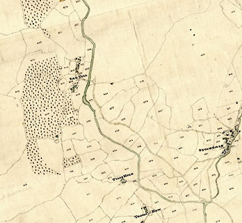 click to enlarge click to enlargeCRny4805.jpg map courtesy of Mark Cropper item:- private collection : 370 Image © see bottom of page |
|
|
|
||
Lakes Guides menu.