 Old Cumbria Gazetteer
 |
 |
|
|||||||||||||||||||||||||||||||||||||||||||||||||||||||||||||||||||||||||||||||||||||||||||||
| included in:- |
 Longsleddale Longsleddale |
||||||||||||||||||||||||||||||||||||||||||||||||||||||||||||||||||||||||||||||||||||||||||||||
| Longsleddale: flood 20120628 | |||||||||||||||||||||||||||||||||||||||||||||||||||||||||||||||||||||||||||||||||||||||||||||||
| site name:- | Sprint, River | ||||||||||||||||||||||||||||||||||||||||||||||||||||||||||||||||||||||||||||||||||||||||||||||
| locality:- | Longsleddale | ||||||||||||||||||||||||||||||||||||||||||||||||||||||||||||||||||||||||||||||||||||||||||||||
| civil parish:- | Longsleddale (formerly Westmorland) | ||||||||||||||||||||||||||||||||||||||||||||||||||||||||||||||||||||||||||||||||||||||||||||||
| county:- | Cumbria | ||||||||||||||||||||||||||||||||||||||||||||||||||||||||||||||||||||||||||||||||||||||||||||||
| locality type:- | flood | ||||||||||||||||||||||||||||||||||||||||||||||||||||||||||||||||||||||||||||||||||||||||||||||
| 1Km square:- | NY4904 (etc etc) | ||||||||||||||||||||||||||||||||||||||||||||||||||||||||||||||||||||||||||||||||||||||||||||||
| 10Km square:- | NY40 (etc) | ||||||||||||||||||||||||||||||||||||||||||||||||||||||||||||||||||||||||||||||||||||||||||||||
|
|
|||||||||||||||||||||||||||||||||||||||||||||||||||||||||||||||||||||||||||||||||||||||||||||||
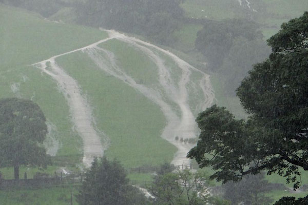 BWX89.jpg Water pouring off the fell; over a parcel called Green, WbyN of Toms Howe, from the Toms Howe beck. (taken 28.6.2012) photos courtesy of Alan Andrews |
|||||||||||||||||||||||||||||||||||||||||||||||||||||||||||||||||||||||||||||||||||||||||||||||
|
|
|||||||||||||||||||||||||||||||||||||||||||||||||||||||||||||||||||||||||||||||||||||||||||||||
| hearsay:- |
Thursday, 28th June 2012: rain up to 11am BST, 0.14ins; 11am-12 0.35ins; 12-1pm 2.31ins;
1-2pm 0.37ins: total 3.03ins=77.0mm in one rain storm just after noon. The rest of
the day had very little rain. The previous two days, Tuesday 0.2ins, Wednesday 0.4ins
had left the ground damp, but not soaked. These readings are at Low Sadgill. |
||||||||||||||||||||||||||||||||||||||||||||||||||||||||||||||||||||||||||||||||||||||||||||||
| I can not give a first hand account as Jean and I left the valley about 11am GMT,
to drive away to a family party in Dorset - we escaped and missed it all, though there
was thunder before we left. We have heard various reports. |
|||||||||||||||||||||||||||||||||||||||||||||||||||||||||||||||||||||||||||||||||||||||||||||||
| The postman, Brian, who reaches the top of the valley about the middle of the day
was stuck at the Stockdale turn, and waited more than 5 hours to get out of the valley.
He was looked after at Stockdale. |
|||||||||||||||||||||||||||||||||||||||||||||||||||||||||||||||||||||||||||||||||||||||||||||||
| After rising over a metre in 20 minutes, the Stockdale Beck took a short cut across
the field on the E side of the road, and took down about 12 feet of wall. |
|||||||||||||||||||||||||||||||||||||||||||||||||||||||||||||||||||||||||||||||||||||||||||||||
| The Tills Hole beck rampaged down the fell side ripping up the stream bed along the
line of the Coniston Limestone Series, and flooded into the ground floor of Tills
Hole. At least one sheep was swept away and her lamb lost. Some hay crop was lost.
The new stream bed has lots of interesting looking exposures of raw rock. |
|||||||||||||||||||||||||||||||||||||||||||||||||||||||||||||||||||||||||||||||||||||||||||||||
| At Toms Howe it came into the house from the back. |
|||||||||||||||||||||||||||||||||||||||||||||||||||||||||||||||||||||||||||||||||||||||||||||||
| A visitor's car on the road at Capplebarrow was caught by a wave of flood water, and
the engine ruined. |
|||||||||||||||||||||||||||||||||||||||||||||||||||||||||||||||||||||||||||||||||||||||||||||||
| A famer noticed the water was over Wadshowe Bridge, which he had seen only once or
twice before. |
|||||||||||||||||||||||||||||||||||||||||||||||||||||||||||||||||||||||||||||||||||||||||||||||
| Mike from Swinkle House went down to collect his daughter from the school bus. On
the way back he stopped when the water was over the bicycle wheel. There was an impromptu
children's party at someone's house down the bottom of the valley. |
|||||||||||||||||||||||||||||||||||||||||||||||||||||||||||||||||||||||||||||||||||||||||||||||
| Surprisingly the water flow at Garnett Bridge was reported as not being exceptionally
bad, perhaps the flooding of meadows really does relieve the problem as it should. |
|||||||||||||||||||||||||||||||||||||||||||||||||||||||||||||||||||||||||||||||||||||||||||||||
| The track from Sadgill to Stile end has been eroded away, some gullies about a metre
deep above the Hoghouse Gate, and a great wash of stones on the track below the gate.
Several times a four wheel drive enthusiast has driven up there, despite notices by
the 4WD association asking for voluntary restraint - don't go and do more damage. |
|||||||||||||||||||||||||||||||||||||||||||||||||||||||||||||||||||||||||||||||||||||||||||||||
| The track from Sadgill to Gatescarth is torn up, as usual, but we've not gone far
up to see what's been done. The county council did get a digger up to do some repairs
about the time we came back from the south. |
|||||||||||||||||||||||||||||||||||||||||||||||||||||||||||||||||||||||||||||||||||||||||||||||
|
|
|||||||||||||||||||||||||||||||||||||||||||||||||||||||||||||||||||||||||||||||||||||||||||||||
| observation:- |
Weather station figures, Low Sadgill, Longsleddale, 28.6.2012 |
||||||||||||||||||||||||||||||||||||||||||||||||||||||||||||||||||||||||||||||||||||||||||||||
| (The figures are given straight from the weather station database; they ought to be
rounded off.) |
|||||||||||||||||||||||||||||||||||||||||||||||||||||||||||||||||||||||||||||||||||||||||||||||
|
|||||||||||||||||||||||||||||||||||||||||||||||||||||||||||||||||||||||||||||||||||||||||||||||
|
|
|||||||||||||||||||||||||||||||||||||||||||||||||||||||||||||||||||||||||||||||||||||||||||||||
| observation:- |
Weather station figures, Middle Swinklebank, 28.6.2012 |
||||||||||||||||||||||||||||||||||||||||||||||||||||||||||||||||||||||||||||||||||||||||||||||
|
|||||||||||||||||||||||||||||||||||||||||||||||||||||||||||||||||||||||||||||||||||||||||||||||
| These are the Middle Swinklebank figures, which are reported to the Meteorological
Office. The difference in numbers at the two places quoted raises the question as
to whose rain gauge do you use: we believe them both individually. In records for
2011 the rain gauge at Sadgill had 25% more than the rain gauge used by the Meteorological
Office at Middle Swinklebank, and that at Murthwaite had 20% less; this seems to be
a regular pattern. |
|||||||||||||||||||||||||||||||||||||||||||||||||||||||||||||||||||||||||||||||||||||||||||||||
|
|
|||||||||||||||||||||||||||||||||||||||||||||||||||||||||||||||||||||||||||||||||||||||||||||||
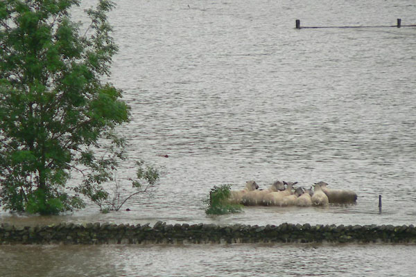
| MN photo:- |
The Stockdale Beck broke its banks in the field called Long Dales, swept across to
the SE corner, and took down the wall to escape. |
||||||||||||||||||||||||||||||||||||||||||||||||||||||||||||||||||||||||||||||||||||||||||||||
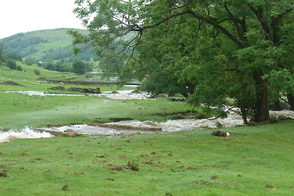 BWX90.jpg Running high. (taken 28.6.2012) photos courtesy of Alan Andrews 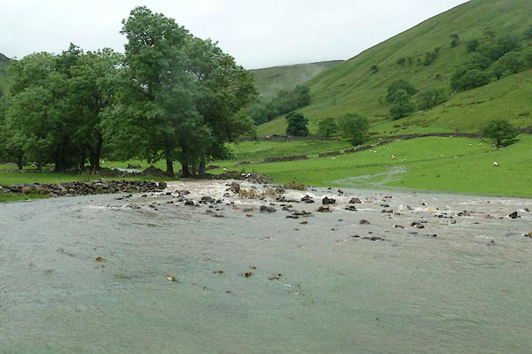 BWX91.jpg The berm of stones broken through. (taken 28.6.2012) photos courtesy of Alan Andrews 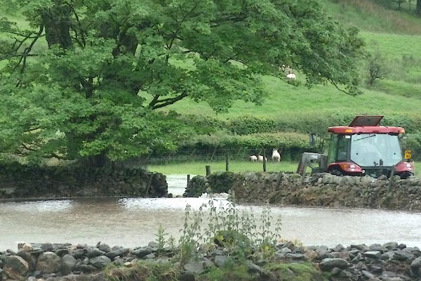 BWX92.jpg On its way out at the corner of the field. (taken 28.6.2012) photos courtesy of Alan Andrews  BWX93.jpg The stones it displaced and left all over the field. (taken 28.6.2012) photos courtesy of Alan Andrews 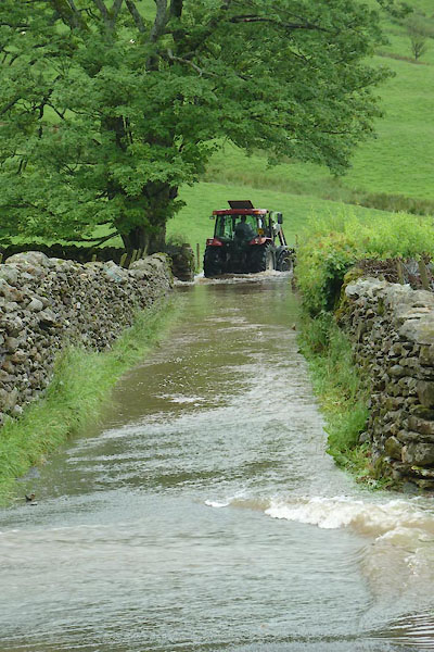 BWX95.jpg In the road by the broken field wall, clearing rocks. (taken 28.6.2012) photos courtesy of Alan Andrews |
|||||||||||||||||||||||||||||||||||||||||||||||||||||||||||||||||||||||||||||||||||||||||||||||
|
|
|||||||||||||||||||||||||||||||||||||||||||||||||||||||||||||||||||||||||||||||||||||||||||||||
| MN photo:- |
|||||||||||||||||||||||||||||||||||||||||||||||||||||||||||||||||||||||||||||||||||||||||||||||
 BWZ46.jpg Youngs tups at Middale (they all survived). (taken 28.6.2012) photos courtesy of Geoff Plant 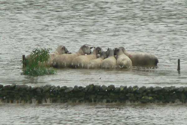 BWZ47.jpg Youngs tups at Middale (they all survived). (taken 28.6.2012) photos courtesy of Geoff Plant 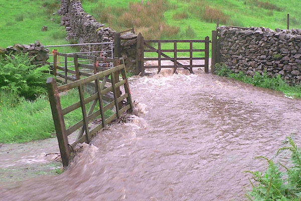 BWZ48.jpg Water at the back of Wadshowe (taken 28.6.2012) photos courtesy of Geoff Plant |
|||||||||||||||||||||||||||||||||||||||||||||||||||||||||||||||||||||||||||||||||||||||||||||||
|
|
|||||||||||||||||||||||||||||||||||||||||||||||||||||||||||||||||||||||||||||||||||||||||||||||
| date:- | 28.6.2012 |
||||||||||||||||||||||||||||||||||||||||||||||||||||||||||||||||||||||||||||||||||||||||||||||
| period:- | 2010s | ||||||||||||||||||||||||||||||||||||||||||||||||||||||||||||||||||||||||||||||||||||||||||||||
| event:- | flood, 2012; rain |
||||||||||||||||||||||||||||||||||||||||||||||||||||||||||||||||||||||||||||||||||||||||||||||
|
|
|||||||||||||||||||||||||||||||||||||||||||||||||||||||||||||||||||||||||||||||||||||||||||||||
Lakes Guides menu.