 Old Cumbria Gazetteer
 |
 |
|
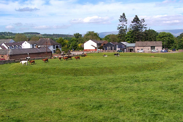
| Arthur's Round Table, Eamont Bridge | ||
| Arthur's Round Table | ||
| King Arthur's Round Table | ||
| locality:- | Eamont Bridge | |
| civil parish:- | Yanwath and Eamont Bridge (formerly Westmorland) | |
| county:- | Cumbria | |
| locality type:- | earthwork | |
| locality type:- | henge | |
| coordinates:- | NY52332838 | |
| 1Km square:- | NY5228 | |
| 10Km square:- | NY52 | |
| SummaryText:- | Circular earthwork bounded by a ditch and bank, prehistoric. | |
|
|
||
 BMF52.jpg (taken 2.6.2006) 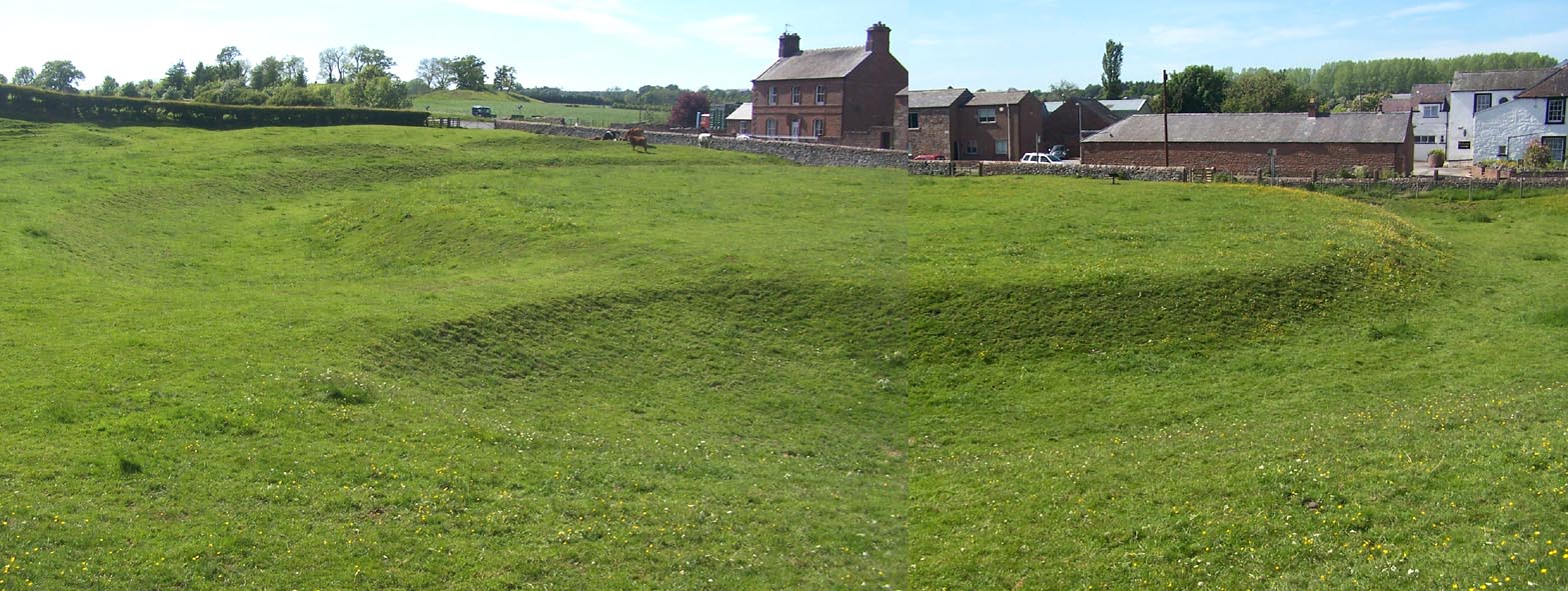 Click to enlarge BMF53.jpg (taken 2.6.2006) |
||
|
|
||
| evidence:- | old map:- OS County Series (Wmd 3 16) placename:- King Arthur's Round Table item:- Arthurian legend |
|
| source data:- | Maps, County Series maps of Great Britain, scales 6 and 25
inches to 1 mile, published by the Ordnance Survey, Southampton,
Hampshire, from about 1863 to 1948. |
|
|
|
||
| evidence:- | poem:- Drayton 1612/1622 text placename:- Arthur's Table |
|
| source data:- | Poem, Poly Olbion, by Michael Drayton, published by published by
John Marriott, John Grismand and Thomas Dewe, and others?
London, part 1 1612, part 2 1622. goto source goto sourcepage 168:- "... And neere to this [Karl Lofts] againe, there is a piece of ground, A little rising Bank, which of the Table round, Men in remembrance keepe, and Arthurs Table name." |
|
|
|
||
| evidence:- | old print:- Camden 1695 |
|
| source data:- | Print, King Arthur's Round Table, Eamont Bridge, Westmorland, in Camden's Britannia,
translated and expanded by Edmund Gibson, published by A Swale, The Unicorn, St Paul's
Churchyard, and by A and J Churchil, The Black Swan, Paternoster Row, London, 1695.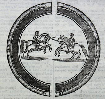 click to enlarge click to enlargeCAM3E2.jpg "A little before Loder joyns the Emot, it passes by a large round entrenchment, with a plain piece of ground in the middle, and a passage into it either side; the form whereof is this: ... It goes by the name of King Arthur's Round Table: and 'tis possible enough that it might bea Justing-place; for which reason we have represented the two Warriors on horse-back in the middle. ..." item:- Armitt Library : A6588.6 Image © see bottom of page |
|
|
|
||
| evidence:- | old map:- Morden 1695 (Wmd) placename:- King Arthur round Table |
|
| source data:- | Map, hand coloured engraving, Westmorland, scale about 2.5 miles to 1 inch, by Robert
Morden, published by Abel Swale, the Unicorn, St Paul's Churchyard, Awnsham, and John
Churchill, the Black Swan, Paternoster Row, London, 1695.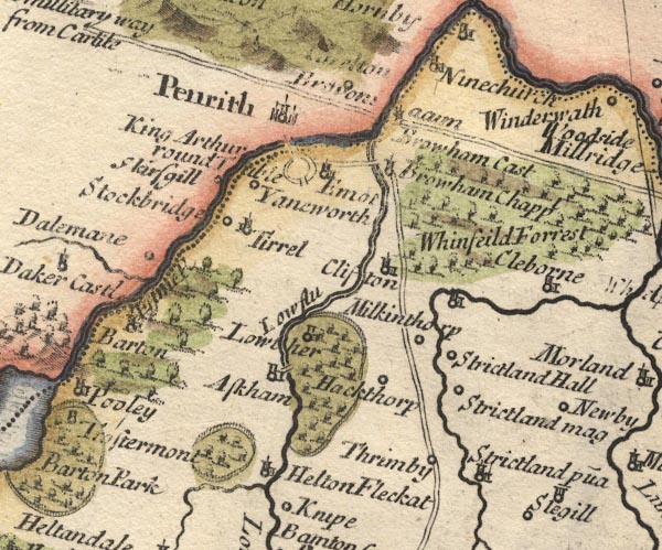 MD10NY52.jpg "King Arthur round Table" Double circle with entrances into the earthwork. item:- JandMN : 24 Image © see bottom of page |
|
|
|
||
| evidence:- | descriptive text:- Fiennes 1698 |
|
| source data:- | Travel book, manuscript record of Journeys through England
including parts of the Lake District, by Celia Fiennes, 1698. "So I returned [from Lowther Hall] 4 mile back to Peroth ... and came by a round green spott of a large circumfference which they keep cut round with a banke round it like a bench; its story is that it was the table a great Giant 6 yards tall used to dine at and there entertained another of nine yards tall which he afterwards killed; there is the length in the Church yard how farre he could leape a great many yards; ..." |
|
|
|
||
| evidence:- | descriptive text:- Simpson 1746 placename:- King Arthur's Round Table item:- cockpit; wrestling; jousting; tournament |
|
| source data:- | Atlas, three volumes of maps and descriptive text published as
'The Agreeable Historian, or the Compleat English Traveller
...', by Samuel Simpson, 1746. goto source Page 1025:- "..." "That which the Country People call King Arthur's Round Table is a little to the South of the Conflux of the Lowther and Eimot. There's a Trench on the Inside of it, by which some think it was a Place for Justs and Tournaments; but others that it was only a Cockpit, or a Ring to wrestle in. ..." |
|
|
|
||
| evidence:- | descriptive text:- Simpson 1746 placename:- King Arthur's Table |
|
| source data:- | Atlas, three volumes of maps and descriptive text published as
'The Agreeable Historian, or the Compleat English Traveller
...', by Samuel Simpson, 1746. goto source "... at a little Distance from the Conflux of the Eimont and Lodor, (at" goto source"which is the round Trench, called King Arthur's Table) ..." |
|
|
|
||
| evidence:- | old map:- Bowen and Kitchin 1760 placename:- King Arthurs Round Table |
|
| source data:- | Map, hand coloured engraving, A New Map of the Counties of
Cumberland and Westmoreland Divided into their Respective Wards,
scale about 4 miles to 1 inch, by Emanuel Bowen and Thomas
Kitchin et al, published by T Bowles, Robert Sayer, and John
Bowles, London, 1760.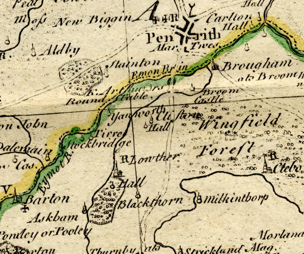 BO18NY42.jpg "K. Arthurs Round Table." double circle item:- Armitt Library : 2008.14.10 Image © see bottom of page |
|
|
|
||
| evidence:- | old map:- Jefferys 1770 (Wmd) placename:- King Arthurs Round Table |
|
| source data:- | Map, 4 sheets, The County of Westmoreland, scale 1 inch to 1
mile, surveyed 1768, and engraved and published by Thomas
Jefferys, London, 1770.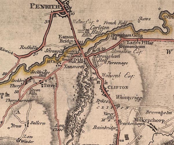 J5NY52NW.jpg "King Arthurs Round Table" double circle item:- National Library of Scotland : EME.s.47 Image © National Library of Scotland |
|
|
|
||
| evidence:- | old map:- Donald 1774 (Cmd) placename:- King Arthurs Round Table |
|
| source data:- | Map, hand coloured engraving, 3x2 sheets, The County of Cumberland, scale about 1
inch to 1 mile, by Thomas Donald, engraved and published by Joseph Hodskinson, 29
Arundel Street, Strand, London, 1774.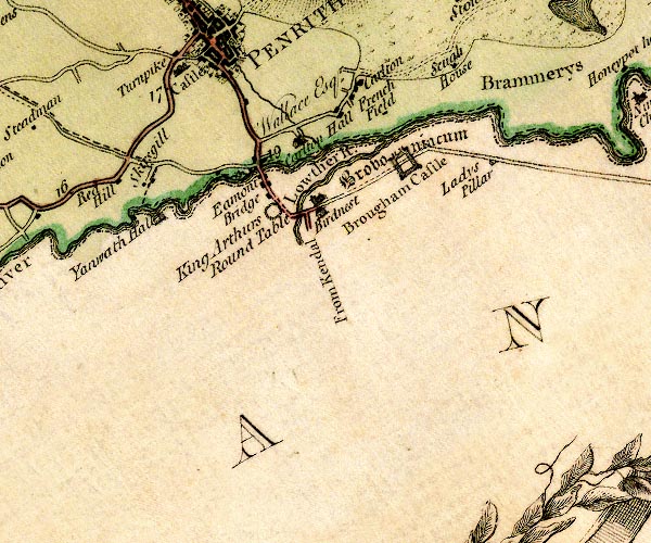 D4NY52NW.jpg "King Arthurs Round Table" circle of hachures or dots item:- Carlisle Library : Map 2 Image © Carlisle Library |
|
|
|
||
| evidence:- | descriptive text:- West 1778 (11th edn 1821) |
|
| source data:- | Guide book, A Guide to the Lakes, by Thomas West, published by
William Pennington, Kendal, Cumbria once Westmorland, and in
London, 1778 to 1821. goto source Page 171:- "... Near Eamont bridge is Arthur's round table, and at a small distance from it is Mayburgh, both of remote antiquity, and doubtful use. The first may be presumed to have been a place of public exhibition for martial exercises, ..." |
|
|
|
||
| evidence:- | old map:- West 1784 map placename:- King Arthurs Round Table |
|
| source data:- | Map, hand coloured engraving, A Map of the Lakes in Cumberland,
Westmorland and Lancashire, scale about 3.5 miles to 1 inch,
engraved by Paas, 53 Holborn, London, about 1784.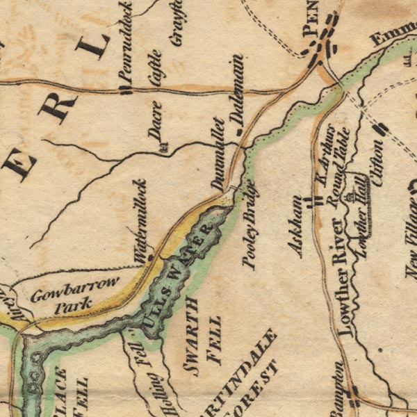 Ws02NY42.jpg item:- Armitt Library : A1221.1 Image © see bottom of page |
|
|
|
||
| evidence:- | old text:- Clarke 1787 placename:- Arthur's Round Table placename:- Round Table item:- Arthurian legend |
|
| source data:- | Guide book, A Survey of the Lakes of Cumberland, Westmorland,
and Lancashire, written and published by James Clarke, Penrith,
Cumberland, and in London etc, 1787; published 1787-93. goto source Page 8:- "..." "About three hundred yards from Lowther Bridge, by the road-side, is a monument of antiquity, called by some Arthur's Round Table, by others simply the Round Table. Authors differ widely as to the origin and use of this place; but there cannot, I think, be a doubt, that it hath been a place for the exercise of arms. It is round, about an hundred and twenty feet diameter, surrounded by a broad ditch, (two openings excepted, which are diametrically opposite to each other,) and all round is a sloping bank of earth, seemingly intended for the accommodation of spectators." "If we allow this to have been a place for the exercise of chivalry, the name of Arthur's Round Table may not improbably be esteemed the genuine one. King Arthur is said to have lived much at Carlisle, and most of the old songs and poems concerning him and his knights have their scene laid in this country, and with these the popular traditions accurately agree, as we shall see hereafter: it is farther remarkable, that the old songs were lost in English, but were afterwards translated from the French, in which language they had been preserved almost entire." "The History of the Order of the Round Table is briefly this: King Arthur observing many quarrels about precedency among his knights, about the year 516 caused a Round Table to be made, at which all the Order, the Sovereign himself not excepted, took their seats promiscuously: To this Table none were admitted but those who had given sufficient proof of their valour and dexterity in the use of arms. As there are some who even deny the existence of King Arthur, I shall not insist farther on this subject, but refer them to other authors, whose province it is more particularly to inquire into these affairs: I shall, however, add from Favine, (lib.5. p.97.) a list of the first table of these knights." "ARTHUR, King of Great Britain." "Galaad. / Percival. / Lancelot. / Gawaine. / Boors. / Lyonnel. / Helias le Blanc. / King Baudomages. / King Ydiir. / King Rions. / King Karadoc of Wales. / The King of Clare. / The Duke of Clarence. / Hector de Marests. / Blioberis. / Gueriot. / Keux de Seneschal. / Yrien the Son of King Vrian. / Brunor the Black. / Bedonier the Constable. / Agloual. / Securades, and / Patrides." "Caxton's old book exhibits a greater number, with the distinguishing epithet of each; but this seems to come nearest the truth, or rather the ancient story." "..." |
|
|
|
||
| evidence:- | old text:- Camden 1789 (Gough Additions) placename:- Round Table, The placename:- Arthur's Castel item:- Little Round Table |
|
| source data:- | Book, Britannia, or A Chorographical Description of the Flourishing Kingdoms of England,
Scotland, and Ireland, by William Camden, 1586, translated from the 1607 Latin edition
by Richard Gough, published London, 1789. goto source Page 161:- "..." ""Within a mile of Perith, but in Westmoreland, is a ruin, as some suppose of a castle, within a flite shot of Loder, and as much of Emot water, standing almost as a mediamnis between them. The ruine is of some called the Round table, and of some Arthur's castel. ..."" "..." goto sourcePage 162:- "... a large circular earthwork, single trenched, the ditch within 29 yards diameter, the two entrances opposite to each other north-west and south-east. This is called Arthur's Round Table. A small distance from this to the south is another such earthwork, consisting only of a low rampart, and called the Little Round Table." |
|
|
|
||
| evidence:- | old map:- Cary 1789 (edn 1805) placename:- King Arthurs Round Table |
|
| source data:- | Map, uncoloured engraving, Westmoreland, scale about 2.5 miles
to 1 inch, by John Cary, London, 1789; edition 1805.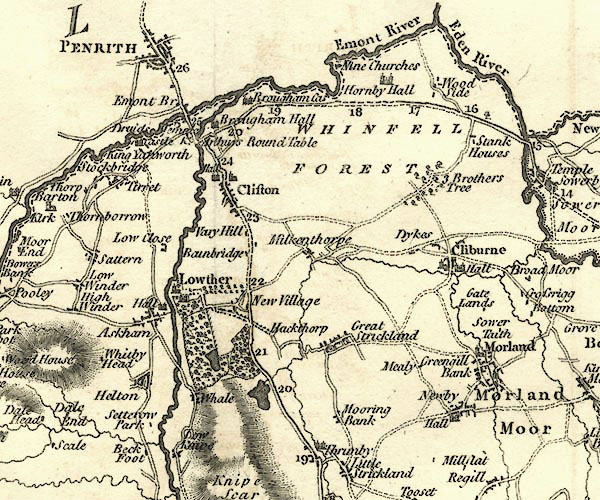 CY24NY52.jpg "K. Arthurs Round Table" circle item:- JandMN : 129 Image © see bottom of page |
|
|
|
||
| evidence:- | descriptive text:- Baker 1802 placename:- Arthur's Round Table |
|
| source data:- | Perspective road map with sections in Lancashire, Westmorland,
and Cumberland, by J Baker, London 1802. pp.25-26:- "... A circular entrenchment seen near the road is called Arthur's round table, supposed by some to have been a place for tournaments in the Saxon times, and by others to have been erected in commemoration of a peace concluded here between the kings of England Scotland and Wales. ..." |
|
|
|
||
| evidence:- | old print:- Otley 1823 (8th edn 1849) placename:- King Arthur's Round Table |
|
| source data:- | Engraving, King Arthur's Round Table, Yanwath and Eamont Bridge, drawn by T Binns,
engraved by O Jewitt, on p.68 of A Descriptive Guide of the English Lakes, by Jonathan
Otley, 8th edition, 1849.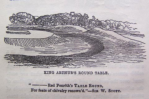 click to enlarge click to enlargeO80E20.jpg item:- Armitt Library : A1180.21 Image © see bottom of page |
|
|
|
||
| evidence:- | descriptive text:- Otley 1823 (5th edn 1834) placename:- King Arthur's Round Table |
|
| source data:- | Guide book, A Concise Description of the English Lakes, the
mountains in their vicinity, and the roads by which they may be
visited, with remarks on the mineralogy and geology of the
district, by Jonathan Otley, published by the author, Keswick,
Cumberland now Cumbria, by J Richardson, London, and by Arthur
Foster, Kirkby Lonsdale, Cumbria, 1823; published 1823-49,
latterly as the Descriptive Guide to the English Lakes. goto source Page 82:- "King Arthur's Round Table is a circular plot of ground about forty yards in diameter, encompassed by a trench and bank of earth; with places of entrance on two opposite sides. It is situated between the rivers Eamont and Lowther, rather more than a mile from Penrith, on the road to Kendal." ".. The dates and purposes of these two interesting pieces of antiquity [Mayburgh], are left entirely to conjecture." |
|
|
|
||
| evidence:- | old text:- Gents Mag |
|
| source data:- | Magazine, The Gentleman's Magazine or Monthly Intelligencer or
Historical Chronicle, published by Edward Cave under the
pseudonym Sylvanus Urban, and by other publishers, London,
monthly from 1731 to 1922. goto source Gentleman's Magazine 1825 part 1 p.515 "Compendium of County History. - Westmorland." "At the South end of the village of EAMONT is a curious circle, consisting of a high dyke of earth and a deep foss within, commonly called Arthur's Round Table. Various are the conjectures respecting it." |
|
|
|
||
| evidence:- | descriptive text:- Ford 1839 (3rd edn 1843) placename:- Arthur's Round Table |
|
| source data:- | Guide book, A Description of Scenery in the Lake District, by
Rev William Ford, published by Charles Thurnam, Carlisle, by W
Edwards, 12 Ave Maria Lane, Charles Tilt, Fleet Street, William
Smith, 113 Fleet Street, London, by Currie and Bowman,
Newcastle, by Bancks and Co, Manchester, by Oliver and Boyd,
Edinburgh, and by Sinclair, Dumfries, 1839. goto source Page 133:- "..." "... Arthur's Round Table, on the banks of the stream, an amphitheatre twenty-nine yards in diameter, surrounded by a ditch and mound. ... Antiquarians have hazarded several but unsatisfactory conjectures, as to the uses of these mysterious structures. They are evidently of British origin, ..." |
|
|
|
||
| evidence:- | old map:- Ford 1839 map placename:- Arthur's Round Table |
|
| source data:- | Map, uncoloured engraving, Map of the Lake District of
Cumberland, Westmoreland and Lancashire, scale about 3.5 miles
to 1 inch, published by Charles Thurnam, Carlisle, and by R
Groombridge, 5 Paternoster Row, London, 3rd edn 1843.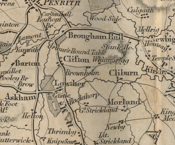 FD02NY52.jpg "Arthur's Round Table" item:- JandMN : 100.1 Image © see bottom of page |
|
|
|
||
| evidence:- | old text:- Harper 1907 placename:- King Arthur's Round Table |
|
| source data:- | Guidebook, The Manchester and Glasgow Road, by Charles G Harper,
published by Chapman and Hall Ltd, London, 1907. HP01p126.txt Page 126:- "..." "... the Lowther is crossed at Lowther Bridge. Beside the river and immediately skirting the road, is the earthwork known as "King Arthur's Round Table," an ancient raised platform whose purpose can only be guessed at. Not King Arthur, but the Norse settlers, are held to have been the originators of it, as the stage whereon their rude displays of arms were held: in particular a duel known as "holmegang," a species of gladiatorial combat in which the opponents were armed with knives, bound together, and then compelled to fight to the death. Such are the fearful memories of this now peaceful scene. ..." |
|
|
|
||
| evidence:- | site plan:- Historical Monuments 1936 placename:- King Arthur's Round Table |
|
| source data:- | Site plan, uncoloured lithograph, King Arthur's Round Table, Eamont Bridge, Yanwath
and Eamont Bridge, Westmorland, scale about 1 to 1900, published by Royal Commission
on Historical Monuments England, London, 1936.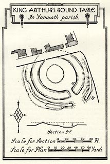 click to enlarge click to enlargeHMW147.jpg On p.252 of the Inventory of the Historical Monuments in Westmorland. printed, top "KING ARTHUR'S ROUND TABLE / In Yanwath parish" RCHME no. Wmd, Yanwath and Eamont Bridge 12 item:- Armitt Library : A745.148 Image © see bottom of page |
|
|
|
||
| notes:- |
Prehistsoric earthwork, about 150x160 feet bounded by ditch and bank. |
|
|
|
||
| person:- | : English Heritage |
|
|
|
||
Lakes Guides menu.