 Old Cumbria Gazetteer
 |
 |
|
| Bleaberry Tarn, Buttermere | ||
| runs into:- |  Sour Milk Gill Sour Milk Gill |
|
|
|
||
| Bleaberry Tarn | ||
| civil parish:- | Buttermere (formerly Cumberland) | |
| county:- | Cumbria | |
| locality type:- | tarn | |
| coordinates:- | NY16591544 (etc) | |
| 1Km square:- | NY1615 | |
| 10Km square:- | NY11 | |
| altitude:- | 1621 feet | |
| altitude:- | 494m | |
|
|
||
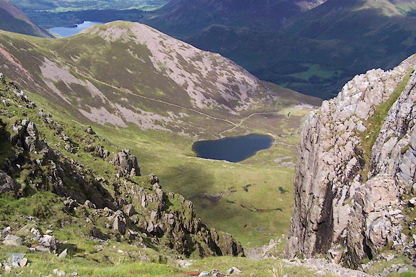
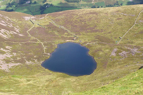 BVH08.jpg (taken 17.8.2011) 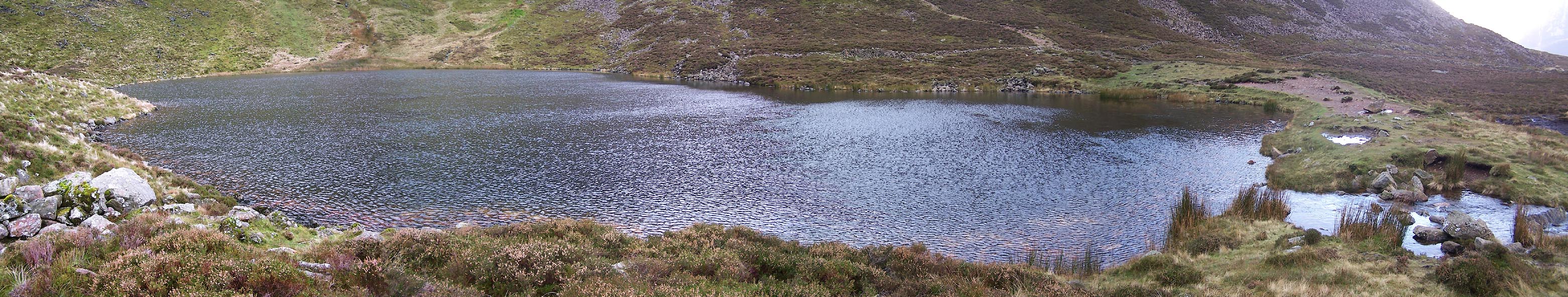 Click to enlarge BVQ04.jpg (taken 1.11.2011) |
||
|
|
||
| evidence:- | old map:- OS County Series (Cmd 69 10) placename:- Bleaberry Tarn |
|
| source data:- | Maps, County Series maps of Great Britain, scales 6 and 25
inches to 1 mile, published by the Ordnance Survey, Southampton,
Hampshire, from about 1863 to 1948. |
|
|
|
||
| evidence:- | perhaps old map:- Saxton 1579 |
|
| source data:- | Map, hand coloured engraving, Westmorlandiae et Cumberlandiae Comitatus ie Westmorland
and Cumberland, scale about 5 miles to 1 inch, by Christopher Saxton, London, engraved
by Augustinus Ryther, 1576, published 1579-1645.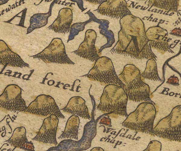 Sax9NY11.jpg item:- private collection : 2 Image © see bottom of page |
|
|
|
||
| evidence:- | possibly old map:- Mercator 1595 (edn?) placename:- |
|
| source data:- | Map, hand coloured engraving, Northumbria, Cumberlandia, et
Dunelmensis Episcopatus, ie Northumberland, Cumberland and
Durham etc, scale about 6.5 miles to 1 inch, by Gerard Mercator,
Duisberg, Germany, about 1595. MER8CumE.jpg "" outline, coast shaded, tinted blue; lake item:- JandMN : 169 Image © see bottom of page |
|
|
|
||
| evidence:- | probably old map:- Speed 1611 (Cmd) |
|
| source data:- | Map, hand coloured engraving, Cumberland and the Ancient Citie
Carlile Described, scale about 4 miles to 1 inch, by John Speed,
1610, published by J Sudbury and George Humble, Popes Head
Alley, London, 1611-12.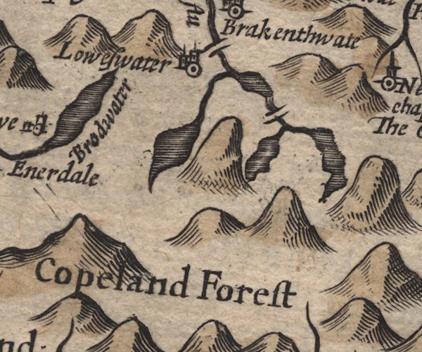 SP11NY11.jpg outline, shaded, oversize item:- private collection : 16 Image © see bottom of page |
|
|
|
||
| evidence:- | probably old map:- Jansson 1646 |
|
| source data:- | Map, hand coloured engraving, Cumbria and Westmoria, ie
Cumberland and Westmorland, scale about 3.5 miles to 1 inch, by
John Jansson, Amsterdam, Netherlands, 1646.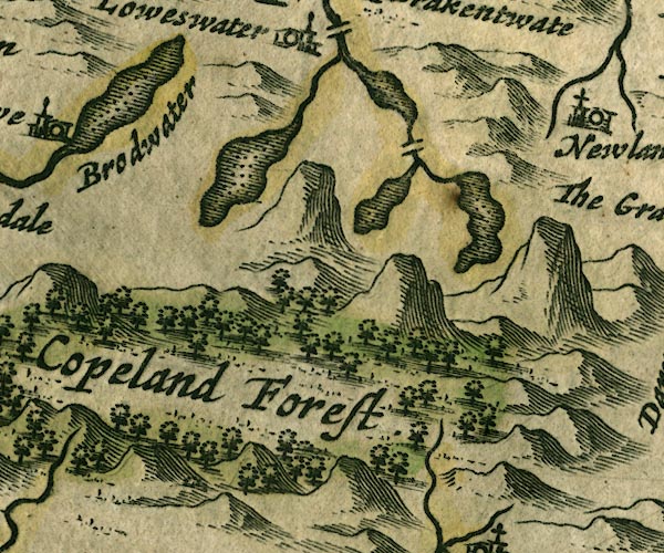 JAN3NY11.jpg Outline with shore shaded, dotted area. item:- JandMN : 88 Image © see bottom of page |
|
|
|
||
| evidence:- | probably old map:- Morden 1695 (Cmd) |
|
| source data:- | Map, uncoloured engraving, Cumberland, scale about 4 miles to 1
inch, by Robert Morden, 1695, published by Abel Swale, the
Unicorn, St Paul's Churchyard, Awnsham, and John Churchill, the
Black Swan, Paternoster Row, London, 1695-1715.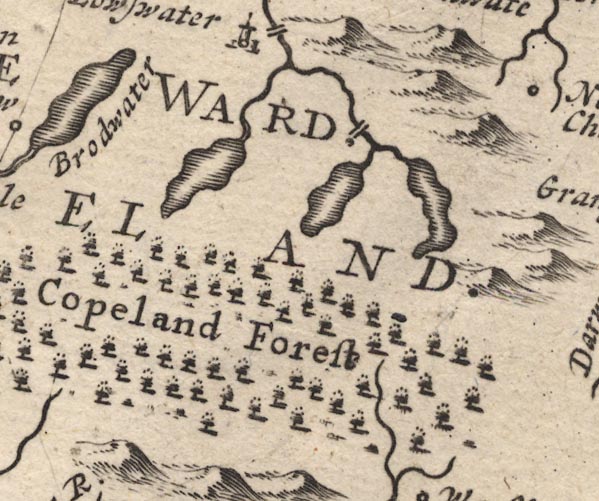 MD12NY11.jpg Outline with shore shading. item:- JandMN : 90 Image © see bottom of page |
|
|
|
||
| evidence:- | old map:- Gents Mag 1751 placename:- Bleeby Tarn |
|
| source data:- | Map, uncoloured engraving, Map of the Black Lead Mines in
Cumberland, and area, scale about 2 miles to 1 inch, by George
Smith, published in the Gentleman's Magazine, 1751. GM1306.jpg "Bleeby Tarn" outline with form lines; lake item:- JandMN : 114 Image © see bottom of page |
|
|
|
||
| evidence:- | old map:- Bowen and Kitchin 1760 |
|
| source data:- | Map, hand coloured engraving, A New Map of the Counties of
Cumberland and Westmoreland Divided into their Respective Wards,
scale about 4 miles to 1 inch, by Emanuel Bowen and Thomas
Kitchin et al, published by T Bowles, Robert Sayer, and John
Bowles, London, 1760. BO18NY11.jpg outline with form lines item:- Armitt Library : 2008.14.10 Image © see bottom of page |
|
|
|
||
| evidence:- | old map:- Donald 1774 (Cmd) placename:- Bleaberry Tarn |
|
| source data:- | Map, hand coloured engraving, 3x2 sheets, The County of Cumberland, scale about 1
inch to 1 mile, by Thomas Donald, engraved and published by Joseph Hodskinson, 29
Arundel Street, Strand, London, 1774.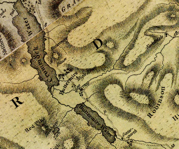 D4NY11NE.jpg "Bleaberry Tarn" lake item:- Carlisle Library : Map 2 Image © Carlisle Library |
|
|
|
||
| evidence:- | descriptive text:- West 1778 (11th edn 1821) |
|
| source data:- | Guide book, A Guide to the Lakes, by Thomas West, published by
William Pennington, Kendal, Cumbria once Westmorland, and in
London, 1778 to 1821. goto source Page 131:- "... large hollow craters scooped in their bosoms, once the seeming seats of raging liquid fire, though at present overflowing with the purest water, that foams down the craggy brows; ..." goto sourcePage 134:- "... Four spiral towering mountains, ... The more southern is, by the dalesmen, from its form, called Hay-rick; the more pyramidal High-crag; the third High-style; and the fourth, from its ferruginous colour, Red-pike. Between the second and third there is a large crater, that, from the parched colour of the conical mountains," goto sourcePage 135:- "in whose bosom it is formed, appears to have been the focus of a volcano, in some distant period of time, when the cones were produced by explosion. At present it is the reservoir of water, that feeds the roaring cataract you see in the descent to Buttermere. Here all is barrenness, solitude, and silence, only interrupted by the murmurs of a rill, that runs unseen in the bottom of a deep dell. ..." |
|
|
|
||
| evidence:- | old map:- Crosthwaite 1783-94 (But/Cru/Low) placename:- Blebba Tarn |
|
| source data:- | Map, uncoloured engraving, An Accurate Map of Buttermere,
Crummock and Loweswater Lakes, scale about 3 inches to 1 mile,
by Peter Crosthwaite, Keswick, Cumberland, 1794, version
published 1800. CT8NY11S.jpg "Blebba Tarn" Drawn detached from the river, indicating it is further off? item:- Armitt Library : 1959.191.2 Image © see bottom of page |
|
|
|
||
| evidence:- | descriptive text:- Otley 1823 (5th edn 1834) placename:- Burtness Tarn placename:- Bleaberry Tarn |
|
| source data:- | Guide book, A Concise Description of the English Lakes, the
mountains in their vicinity, and the roads by which they may be
visited, with remarks on the mineralogy and geology of the
district, by Jonathan Otley, published by the author, Keswick,
Cumberland now Cumbria, by J Richardson, London, and by Arthur
Foster, Kirkby Lonsdale, Cumbria, 1823; published 1823-49,
latterly as the Descriptive Guide to the English Lakes. goto source Page 39:- "[Burt]ness Tarn, or Bleaberry Tarn, lies of the south-west side of Buttermere, in a recess between High Stile and Red Pike; its stream forms the cataract called Sour-milk gill. ..." "..." goto sourcePage 126:- "... three adjoining summits are called High-crag, High-stile, and Red-pike. ... between the second and third lies Burtness Tarn." |
|
|
|
||
| evidence:- | old map:- Garnett 1850s-60s H placename:- Bleaberry Tarn |
|
| source data:- | Map of the English Lakes, in Cumberland, Westmorland and
Lancashire, scale about 3.5 miles to 1 inch, published by John
Garnett, Windermere, Westmorland, 1850s-60s.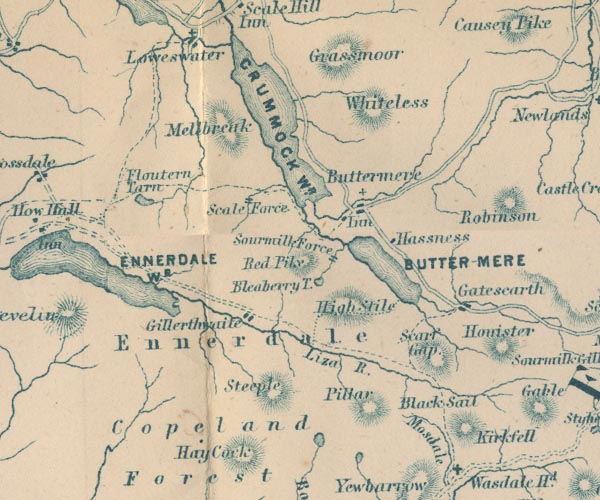 GAR2NY11.jpg "Bleaberry T." outline with shore form lines, lake or tarn item:- JandMN : 82.1 Image © see bottom of page |
|
|
|
||
| evidence:- | old text:- Martineau 1855 placename:- Bleaberry Tarn placename:- Burtness Tarn |
|
| source data:- | Guide book, A Complete Guide to the English Lakes, by Harriet
Martineau, published by John Garnett, Windermere, Westmorland,
and by Whittaker and Co, London, 1855; published 1855-76. goto source Page 133:- "... Sourmilk Ghyll ... issues from Bleaberry, or Burtness Tarn, on the side of Red Pike. ..." |
|
|
|
||
| evidence:- | outline view:- Black 1856 placename:- Bleaberry Tarn |
|
| source data:- | Print, lithograph, Outline Views, Buttermere - Mountains as seen from the Knots near
the Hotel at Buttermere, and Mountains as seen at the Seat in Lanthwaite Wood, Scale
Hill, by J Flintoft, Keswick, Cumberland, engraved by R Mason, Edinburgh, Lothian,
about 1900.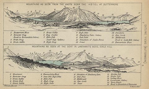 click to enlarge click to enlargeBC08E5.jpg "... 10 Bleaberry Tarn ... 11 Situation of Bleaberry Tarn ..." item:- JandMN : 37.19 Image © see bottom of page |
|
|
|
||
| evidence:- | outline view:- Black 1841 (3rd edn 1846) placename:- Bleaberry Tarn |
|
| source data:- | Print, engraving, outline view, Mountains as seen from The Knots near the Victoria
at Buttermere, and Mountains as seen at the Seat in Lanthwaite Wood, Scale Hill, by
J Flintoft, Keswick, Cumberland, engraved by R Mason, Edinburgh, Lothian, about 1846.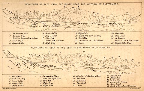 click to enlarge click to enlargeBC02E7.jpg "... 10 Bleaberry Tarn ... 11 Situation of Bleaberry Tarn ..." item:- JandMN : 32.11 Image © see bottom of page |
|
|
|
||
 BVH09.jpg (taken 17.8.2011) 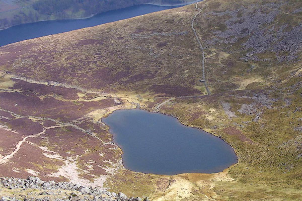 BPA54.jpg (taken 16.4.2008) 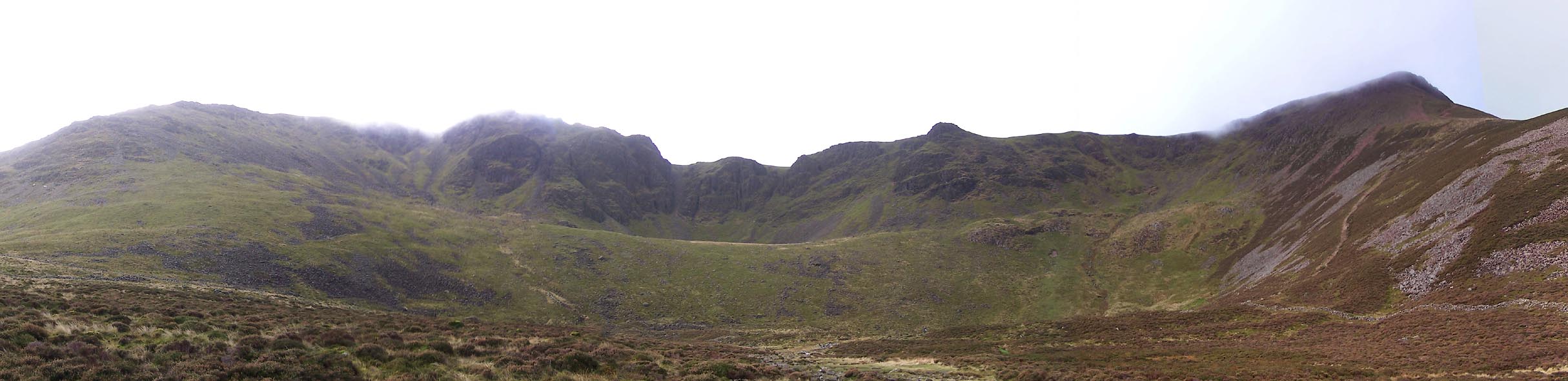 Click to enlarge BVQ05.jpg Hills behind; High Stile, Chapel Crags, Red Pike. (taken 1.11.2011) |
||
| The tarn sits in a cirque, with what looks like another cirque above it. |
||
|
|
||
| notes:- |
Nancy Price:- |
|
| "Lonely Bleaberry Tarn seems to be floating detached as if surprised to find itself
so high up instaed of in a comfortable valley. It seems to dislike the wind that turns
its surface into gooseflesh,and it is always shivering, even in the sun." |
||
| Baron 1925 |
||
|
|
||
Lakes Guides menu.