 Old Cumbria Gazetteer
 |
 |
|
||||||||||||||||||||||||||||||||
| Cross Fell, Culgaith | ||||||||||||||||||||||||||||||||||
| Cross Fell | ||||||||||||||||||||||||||||||||||
| Fiend's Fell | ||||||||||||||||||||||||||||||||||
| civil parish:- | Culgaith (formerly Cumberland) | |||||||||||||||||||||||||||||||||
| county:- | Cumbria | |||||||||||||||||||||||||||||||||
| locality type:- | hill | |||||||||||||||||||||||||||||||||
| coordinates:- | NY68733432 (etc) | |||||||||||||||||||||||||||||||||
| 1Km square:- | NY6834 | |||||||||||||||||||||||||||||||||
| 10Km square:- | NY63 | |||||||||||||||||||||||||||||||||
| altitude:- | 2930 feet | |||||||||||||||||||||||||||||||||
| altitude:- | 893m | |||||||||||||||||||||||||||||||||
|
|
||||||||||||||||||||||||||||||||||
| evidence:- | old map:- OS County Series (Cmd 51 8) placename:- Cross Fell |
|||||||||||||||||||||||||||||||||
| source data:- | Maps, County Series maps of Great Britain, scales 6 and 25
inches to 1 mile, published by the Ordnance Survey, Southampton,
Hampshire, from about 1863 to 1948. |
|||||||||||||||||||||||||||||||||
|
|
||||||||||||||||||||||||||||||||||
| evidence:- | old map:- Morden 1695 (Wmd) placename:- Cross Fell |
|||||||||||||||||||||||||||||||||
| source data:- | Map, hand coloured engraving, Westmorland, scale about 2.5 miles to 1 inch, by Robert
Morden, published by Abel Swale, the Unicorn, St Paul's Churchyard, Awnsham, and John
Churchill, the Black Swan, Paternoster Row, London, 1695.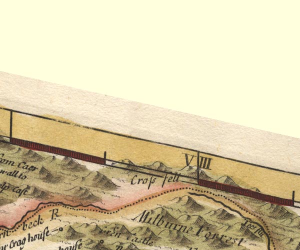 MD10NY73.jpg "Cross fell" Hillocks. item:- JandMN : 24 Image © see bottom of page |
|||||||||||||||||||||||||||||||||
|
|
||||||||||||||||||||||||||||||||||
| evidence:- | descriptive text:- Simpson 1746 placename:- Crosse Fells placename:- Fiends Fells placename:- Devil's Fells |
|||||||||||||||||||||||||||||||||
| source data:- | Atlas, three volumes of maps and descriptive text published as
'The Agreeable Historian, or the Compleat English Traveller
...', by Samuel Simpson, 1746. goto source goto source"... it was thought an extraordinary Piece of Devotion in those Parts, (and Wormius testifies the same of Denmark) to erect Crosses and build Chapels in the most eminent Places, as being nearer Heaven, and more conspicuous: they were commonly dedicated to St. Michael: On the same Account the large Tract of Mountains, which runs thro' the E. Side of the County, is call'd Crosse Fells; for before they were call'd Fiends, or Devil's Fells, as a small Town at the Bottom of them still bears the Name of Dilston, i.e. Devil's Town." |
|||||||||||||||||||||||||||||||||
|
|
||||||||||||||||||||||||||||||||||
| evidence:- | old text:- Gents Mag placename:- Crossfell Mountain |
|||||||||||||||||||||||||||||||||
| source data:- | Magazine, The Gentleman's Magazine or Monthly Intelligencer or
Historical Chronicle, published by Edward Cave under the
pseudonym Sylvanus Urban, and by other publishers, London,
monthly from 1731 to 1922. goto source Gentleman's Magazine 1747 p.384 "... ..." "A Journey up to Cross-fell Mountain." "THE following account of Cross-fell, will entertain such of your readers whose genius inclines them to the description of romantic scenes." "A mountain that is generally ten months bury'd in snow, and eleven in clouds, cannot fail of exciting the attention and curiosity of a traveller." "That immense ridge of mountains, which are reputed the British Alps, make their first appearance in Derbyshire, and are thence continu'd in one chain of different elevations to the river Tweed. The Lancashire and Copland heights, with those in Yorkshire and Durham, being only detach'd parts of this great body, such as are remarkably eminent have particular names assign'd them, whilst the general ridge bears one appellation for several miles together." "Cross-fell, tho' distinguished in none of our county maps, is most singularly eminent, whether you regard its height, or the immense base it stands on, being above 20 miles in circumference; in some parts the rise is very leisurely and gradual, in others more rugged and perpendicular, emitting considerable streams to both seas. This insensible ascent removes its top to a very great distance from the inhabited plains, and being in a manner encompassed with other desolate and barren mountains, it retains the snow much longer than any other we can see in Britain, there being some who affirm that it has continued sometimes for seven whole years together." |
|||||||||||||||||||||||||||||||||
|
|
||||||||||||||||||||||||||||||||||
| evidence:- | old text:- Gents Mag 1747 item:- placename, Cross Fell; viewpoint; swallow hole; pothole; flower; Scorpioides arvensis; tormentil |
|||||||||||||||||||||||||||||||||
| source data:- | Map, perspective view, Caudbeck Fells ie Caldbeck Fells, scale about 1+ miles to 1
inch, and descriptive text, published in the Gentleman's Magazine, November 1747. goto source Gentleman's Magazine 1747 p.385 "Aldstone is the nearest town where one can get a safe conductor to cross these almost impervious wastes, a country extremely ill represented in all our maps yet published, not to mention their exhibiting the towns on the wrong side of the river [Nint]. About two in the afternoon we set forward three in company, and two who join'd us afterwards, out of the same curiosity. We pass'd the river Tine near its confluence with Blackaburn, beyond which this immense waste begins, and could plainly perceive the alteration of air in riding a few miles. On the top of Roderic heights is a pretty large lake, call'd Green-castle-loch, which receives no visible feeder, but emits a small stream northward to the said burn; nor is there any vestige of a castle, from which it could be presum'd to borrow the name. The Swallows, those incontestable remains of Noah's deluge, begin here to be very frequent. Some of these are 30 or 40 yards in diameter, and near as much deep, perfectly circular, but contain no water at any season, the ground having gradually fallen in at the sinking of the waters; but where they have happen'd amid rocks, the holes are left open to incredible depths. This naturally accounts for those surprizing phaenomena in the Pyrenean and Narbone mountains, and our Elden-hole in Derbyshire, whose depths have never been ascertained with the longest lines." "On the descent of Roderic-fell there is plenty of herbage, but few plants, save the scorpioides arvensis, and tormentil." "At the bottom of this height Blackaburn is divided into two branches, the eastermost tumbling over a precipice of 40 perpendicular yards, which makes a most wild, surprizing cascade." "From this rivulet we are to account the rise of Cross-fell. We were now so much environ'd with large and extended morasses, rocks and mountains, that they exhibited a very frightful appearance, not the vestige of a house, except some old shiels, where in former ages the people had resorted like the Asiatic Tartars to graze their cattle in summer, a practice now quite disus'd. There were a few sheep, but no deer, that we could see, tho' there are several on the heights; and notwithstanding the extraordinary drought, the water follow'd our horses footsteps for miles together, except where the ground was perfectly rotten. At a place call'd Bulmans cleugh there have been formerly lead-works, now left off. We had now ascended gradually about 3 miles, thro' very broken morassy wastes, when the mountain began to rise in three very formidable ascents, very steep, in the manner of mount Lebanon, pil'd one above another, with large and extensive plains to each of them, and loose shivery stones on ye brows, very troublesome to the horses which we now were obliged sometimes to quit. This continu'd for near 2 miles more, when we got on the edge of the highest, which forms a capacious plain of several hundred acres, if you reckon from the East ascent; but of such a barren soil, that there was not so much as a single leaf of grass, herb or plant to be found in so large a plain, exclusive of a few of those rings attributed to fairies, some of which are perfect circles of the Gramen gluinis variis, in botany, ascrib'd by Linnaeus in his description of the Baltic isles to a particular quality of its affecting the dirtiest soil, where no other grass can survive. This immense plain has no verdure, therefore, but a venerably grey aspect from the moss or down, and even this can hardly draw a subsistence to support itself; so inconceivably barren is this distinguish'd eminence. The West side towards the Cumberland plains is more rocky and steep than the way we ascended. Great part of six counties were to be seen, and notwithstanding our height, there seemed to be 4 or 5 mountains that disputed preheminence, the rest all look'd far below us. These were Skiddaw in the West of Cumberland, Criffield in Scotland, Pennygent and Ingleborough in Yorkshire, and the highest Cheviot in Northumberland. I computed the diameter of our visible horizon to exceed 120 miles, 60 each way from the center. The mountains in Cleveland by the east sea were very fair, and the West sea sufficiently discoverable. As to the perpendicular height of the mountain, I could not so well judge, having no barometer, and the top suffers too much by refraction to be ascertain'd on geometrical principles." "Whether it takes its name Cross-fell from its transverse situation to the common run of that ridge, or from a papistical conjuring a cross to dislodge the aerial daemons, which that religion has ascribed to this desolate mountain, I take not upon me to determine." "P. S. Being the 13th of August, and a long drought, and hot season, we were not able to find any least relicks of snow, in places most likely for it; which is very extraordinary." "..." |
|||||||||||||||||||||||||||||||||
|
|
||||||||||||||||||||||||||||||||||
| evidence:- | old map:- Jefferys 1770 (Wmd) placename:- Cross Fell |
|||||||||||||||||||||||||||||||||
| source data:- | Map, 4 sheets, The County of Westmoreland, scale 1 inch to 1
mile, surveyed 1768, and engraved and published by Thomas
Jefferys, London, 1770.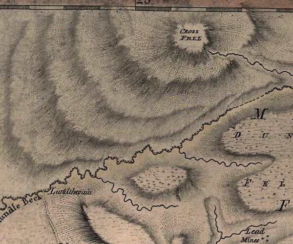 J5NY63SE.jpg "CROSS FELL" hill hachuring; hill or mountain item:- National Library of Scotland : EME.s.47 Image © National Library of Scotland |
|||||||||||||||||||||||||||||||||
|
|
||||||||||||||||||||||||||||||||||
| evidence:- | old text:- Pennant 1773 placename:- Cross Fell item:- Cross Fell, altitude |
|||||||||||||||||||||||||||||||||
| source data:- | Book, A Tour from Downing to Alston Moor, 1773, by Thomas
Pennant, published by Edward Harding, 98 Pall Mall, London, 1801. goto source Pennant's Tour 1773, page 186 "I soon fell into my former track at Castle-carrock, a small village and parish at the foot of the great mountain Cross-fell. To this mountain Donald, in his map of Cumberland, gives the height of nine hundred and ninety-eight yards above Bassenthwaite-water, and eleven hundred and eight above the sea. ..." |
|||||||||||||||||||||||||||||||||
|
|
||||||||||||||||||||||||||||||||||
| evidence:- | old map:- Donald 1774 (Cmd) placename:- Cross Fell |
|||||||||||||||||||||||||||||||||
| source data:- | Map, hand coloured engraving, 3x2 sheets, The County of Cumberland, scale about 1
inch to 1 mile, by Thomas Donald, engraved and published by Joseph Hodskinson, 29
Arundel Street, Strand, London, 1774.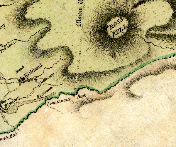 D4NY63SE.jpg "CROSS FELL" hill hachuring; a hill or mountain item:- Carlisle Library : Map 2 Image © Carlisle Library |
|||||||||||||||||||||||||||||||||
|
|
||||||||||||||||||||||||||||||||||
| evidence:- | descriptive text:- West 1778 (11th edn 1821) |
|||||||||||||||||||||||||||||||||
| source data:- | Guide book, A Guide to the Lakes, by Thomas West, published by
William Pennington, Kendal, Cumbria once Westmorland, and in
London, 1778 to 1821. goto source Page 108:- "... To the east, Cross-fell is discerned" goto sourcePage 109:- "... like a cloud of blue mist, hanging over the horizon. ..." goto sourceAddendum; Mr Gray's Journal, 1769 Page 200:- "... walked up beacon-hill [Penrith], ... To the east, Cross-fell, just visible through mists and vapours hovering round it." |
|||||||||||||||||||||||||||||||||
|
|
||||||||||||||||||||||||||||||||||
| evidence:- | old text:- Camden 1789 (Gough Additions) placename:- Cross Fells placename:- Brinds Fell placename:- Devil's Fell |
|||||||||||||||||||||||||||||||||
| source data:- | Book, Britannia, or A Chorographical Description of the Flourishing Kingdoms of England,
Scotland, and Ireland, by William Camden, 1586, translated from the 1607 Latin edition
by Richard Gough, published London, 1789. goto source Page 180:- "... The large tract of mountains on the east side of the county called Cross Fells, one of the highest mountains in the north, have the name given them on that account [a chapel built there as an eminent place], being before called Brinds fell, Devils fell; and Dilston, a small town under them is contracted from Devilston." |
|||||||||||||||||||||||||||||||||
|
|
||||||||||||||||||||||||||||||||||
| evidence:- | old map:- Bailey 1797 placename:- Cross Fell |
|||||||||||||||||||||||||||||||||
| source data:- | Map, soil etc, uncoloured engraving, Cumberland, scale about 21
miles to 1 inch, by J Bailey, engraved by Neele, Strand,
published by Messrs Robinson, Paternoster Row and G Nicol, Pall
Mall, London, 1797. click to enlarge click to enlargeBY04.jpg "Cross Fell" item:- Armitt Library : A680.2 Image © see bottom of page |
|||||||||||||||||||||||||||||||||
|
|
||||||||||||||||||||||||||||||||||
| evidence:- | old map:- Cooper 1808 placename:- Cross Fell |
|||||||||||||||||||||||||||||||||
| source data:- | Map, uncoloured engraving, Cumberland, scale about 10.5 miles to
1 inch, drawn and engraved by Cooper, published by R Phillips,
Bridge Street, Blackfriars, London, 1808. click to enlarge click to enlargeCOP3.jpg "Cross Fell" hill hachuring; mountain or hill item:- JandMN : 86 Image © see bottom of page |
|||||||||||||||||||||||||||||||||
|
|
||||||||||||||||||||||||||||||||||
| evidence:- | descriptive text:- Otley 1823 (5th edn 1834) item:- latitude; longitude; lat and long |
|||||||||||||||||||||||||||||||||
| source data:- | Guide book, A Concise Description of the English Lakes, the
mountains in their vicinity, and the roads by which they may be
visited, with remarks on the mineralogy and geology of the
district, by Jonathan Otley, published by the author, Keswick,
Cumberland now Cumbria, by J Richardson, London, and by Arthur
Foster, Kirkby Lonsdale, Cumbria, 1823; published 1823-49,
latterly as the Descriptive Guide to the English Lakes. goto source Page 78:- "STATION II.- SKIDDAW." "Latitude 54° 39′ 12″ N. Longitude 3° 8′ 9″W. Height 3022 feet." goto sourcePage 79:- "STATION III.- HELVELLYN." "Latitude 54° 31′ 43″ N. Longitude 3° 0′ 24″W. Height 3070 feet."
|
|||||||||||||||||||||||||||||||||
|
|
||||||||||||||||||||||||||||||||||
| evidence:- | old text:- Gents Mag placename:- Fiend's Fell item:- cross; altar |
|||||||||||||||||||||||||||||||||
| source data:- | Magazine, The Gentleman's Magazine or Monthly Intelligencer or
Historical Chronicle, published by Edward Cave under the
pseudonym Sylvanus Urban, and by other publishers, London,
monthly from 1731 to 1922. goto source Gentleman's Magazine 1825 part 1 p.515 "Compendium of County History. - Westmorland." "CROSS-FELL is reported to have been formerly called Fiend's Fell, from evil spirits haunting its top, till St. Austin erected there a cross and an altar, by which he broke their haunts; hence its present name." |
|||||||||||||||||||||||||||||||||
|
|
||||||||||||||||||||||||||||||||||
| evidence:- | descriptive text:- Ford 1839 (3rd edn 1843) placename:- Cross Fell item:- altitude, Cross Fell |
|||||||||||||||||||||||||||||||||
| source data:- | Guide book, A Description of Scenery in the Lake District, by
Rev William Ford, published by Charles Thurnam, Carlisle, by W
Edwards, 12 Ave Maria Lane, Charles Tilt, Fleet Street, William
Smith, 113 Fleet Street, London, by Currie and Bowman,
Newcastle, by Bancks and Co, Manchester, by Oliver and Boyd,
Edinburgh, and by Sinclair, Dumfries, 1839. goto source Page 178:- "ELEVATION OF THE MOUNTAINS," "ACCORDING TO DIFFERENT AUTHORITIES."
|
|||||||||||||||||||||||||||||||||
|
|
||||||||||||||||||||||||||||||||||
| evidence:- | old map:- Ford 1839 map placename:- Cross Fell |
|||||||||||||||||||||||||||||||||
| source data:- | Map, uncoloured engraving, Map of the Lake District of
Cumberland, Westmoreland and Lancashire, scale about 3.5 miles
to 1 inch, published by Charles Thurnam, Carlisle, and by R
Groombridge, 5 Paternoster Row, London, 3rd edn 1843.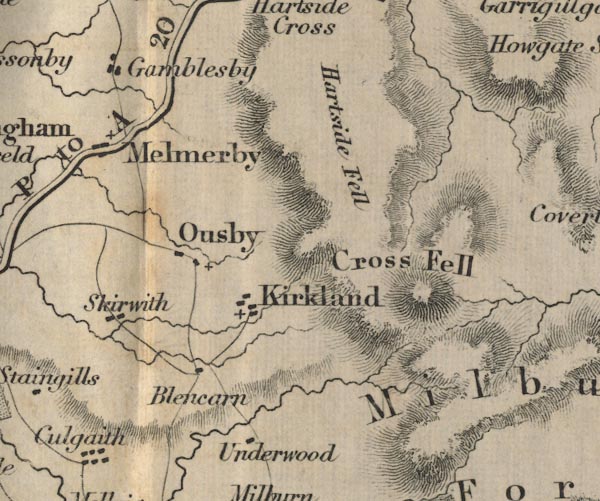 FD02NY63.jpg "Cross Fell" Hill hachuring. item:- JandMN : 100.1 Image © see bottom of page |
|||||||||||||||||||||||||||||||||
|
|
||||||||||||||||||||||||||||||||||
| evidence:- | old map:- Garnett 1850s-60s H placename:- Cross Fell |
|||||||||||||||||||||||||||||||||
| source data:- | Map of the English Lakes, in Cumberland, Westmorland and
Lancashire, scale about 3.5 miles to 1 inch, published by John
Garnett, Windermere, Westmorland, 1850s-60s.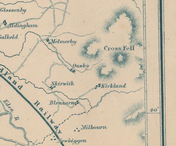 GAR2NY63.jpg "Cross Fell" hill hachuring item:- JandMN : 82.1 Image © see bottom of page |
|||||||||||||||||||||||||||||||||
|
|
||||||||||||||||||||||||||||||||||
| evidence:- | descriptive text:- Clarke 1858 placename:- Cross Fell |
|||||||||||||||||||||||||||||||||
| source data:- | Report, Account of the Observations and Calculations of the
Principal Triangulation, by Captain Alexander Ross Clarke,
published by the Ordnance Survey, London, 1858. "CROSS FELL, 1841, is a remarkable mountain, about 9 miles south of Alston, in Cumberland. The station is on its summit, and may be discovered by means of the stones placed round the staff." "CROSS FELL 3-ft. Theodolite From 3rd October to 27th November 1841. Observer: Lieut. PIPON, R.E." Objects / Bearings in degrees, minutes and decimal seconds. "Sca Fell / 59 42 28.14" "Helvellyn / 60 27 46.04" "High Pike / 90 38 39.84" "Ben Cairn / 102 1 22.25" "Cairnsmuir of Fleet / 105 2 34.70" "Criffel / 110 17 46.33" "Merrick / 111 43 50.93" "Cairnsmuir on Deugh / 119 49 31.27" "Burnswark / 131 0 19.03" "Hart Fell / 143 42 25.97" "Wisp / 154 46 49.00" "Dunrich / 155 34 44.83" "Cheviot / 194 2 34.32" "Collier Law / 256 50 10.58" "Bolton Head / 289 27 25.84" "Black Hambleton / 298 20 2.13" "Water Crag / 320 28 22.19" "Great Whernside / 332 5 31.69" "Little Whernside / 354 4 8.57" "Ingleboro' / 354 26 22.07" Altitude above mean sea level:- "2927.8 feet" Position, latitude and longitude, degrees minutes decimal seconds "54 42 10.76 / 2 29 6.73" |
|||||||||||||||||||||||||||||||||
|
|
||||||||||||||||||||||||||||||||||
| evidence:- | text:- Mason 1907 (edn 1930) item:- altitude, Cross Fell |
|||||||||||||||||||||||||||||||||
| source data:- | Text book, The Ambleside Geography Books bk.III, The Counties of
England, by Charlotte M Mason, published by Kegan Paul, Trench,
Trubner and Co, Broadway House, 68-74 Carter Lane, and the
Parents' Educational Union Office, 26 Victoria Street, London,
edn 1930. MSN1P025.txt Page 25:- "... Pennine Chain." "Cross Fell, 2900 feet, the highest point in the range, is in Cumberland. ..." |
|||||||||||||||||||||||||||||||||
|
|
||||||||||||||||||||||||||||||||||
| evidence:- | old map:- Postlethwaite 1877 (3rd edn 1913) placename:- Cross Fell |
|||||||||||||||||||||||||||||||||
| source data:- | Map, uncoloured engraving, Map of the Lake District Mining Field, Westmorland, Cumberland,
Lancashire, scale about 5 miles to 1 inch, by John Postlethwaite, published by W H
Moss and Sons, 13 Lowther Street, Whitehaven, Cumberland, 1877 edn 1913. PST2NY63.jpg "Cross Fell" hill hachuring item:- JandMN : 162.2 Image © see bottom of page |
|||||||||||||||||||||||||||||||||
|
|
||||||||||||||||||||||||||||||||||
 Helm Wind Helm Wind |
||||||||||||||||||||||||||||||||||
|
|
||||||||||||||||||||||||||||||||||
| hearsay:- |
The fell with its fiendish wind was known as Fiend's Fell. Paulinus, a priest from
Rome who came to help Augustine as a missionary, 601, came to Northumberland in 627.
He was accompanying a princess from the Kingdom of Kent who was to marry Edwin, King
of Northumbria. Whilst in the north, Paulinus is said to have erected an altar and
a cross on the summit of the fell, and renamed it Cross Fell. The old name, more apt
is less proper, was still in use as late as the 15th century. |
|||||||||||||||||||||||||||||||||
|
|
||||||||||||||||||||||||||||||||||
| hearsay:- |
"... the sixth and highest elevation is Cross Fell which is the summit of this ridge
of mountains; it was formerly called Fiend's Fell, from evil Spirits which are said
in former Times to have haunted the Top of this Mountain; and continued their Haunts
and Nocturnal Vagaries upon it, until St. Austin, as is said, erected a Cross and
built an Altar upon it, whereon he offered the Holy Eucharist, by which he countercharm'd
those Hellish Fiend, and broke their Haunts." |
|||||||||||||||||||||||||||||||||
| "... and to this day there is a heap of stones which goes by the name of the Altar
..." |
||||||||||||||||||||||||||||||||||
| Robinson, T: 1790: Essay Towards a Natural History of Westmorland and Cumberland:
(London) |
||||||||||||||||||||||||||||||||||
|
|
||||||||||||||||||||||||||||||||||
Lakes Guides menu.