 Old Cumbria Gazetteer
 |
 |
|
| included in:- |
 Karl Lofts, Shap probably Karl Lofts, Shap probably
|
|
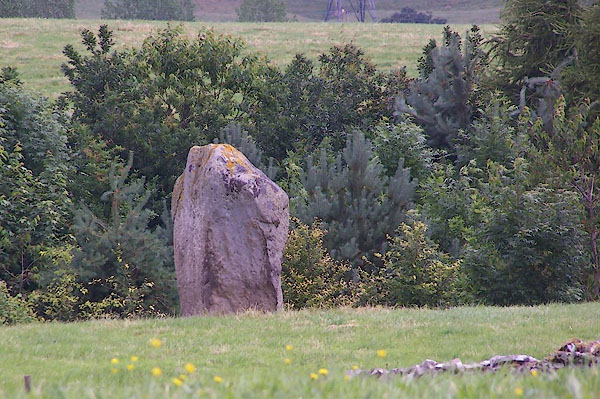
| Goggleby Stone, Shap | ||
| Goggleby Stone | ||
| Gogglesby Stone | ||
| civil parish:- | Shap (formerly Westmorland) | |
| county:- | Cumbria | |
| locality type:- | standing stone | |
| locality type:- | stone | |
| locality type:- | stone alignment | |
| coordinates:- | NY55911509 | |
| 1Km square:- | NY5515 | |
| 10Km square:- | NY51 | |
|
|
||
 BJQ41.jpg (taken 22.7.2005) |
||
|
|
||
| evidence:- | old map:- OS County Series (Wmd 14 14) placename:- Goggleby Stone |
|
| source data:- | Maps, County Series maps of Great Britain, scales 6 and 25
inches to 1 mile, published by the Ordnance Survey, Southampton,
Hampshire, from about 1863 to 1948. |
|
|
|
||
| evidence:- | old text:- Gents Mag placename:- Guggleby Stone |
|
| source data:- | Magazine, The Gentleman's Magazine or Monthly Intelligencer or
Historical Chronicle, published by Edward Cave under the
pseudonym Sylvanus Urban, and by other publishers, London,
monthly from 1731 to 1922. goto source Gentleman's Magazine 1824 part 1 p.4 "..." "One of the most prominent that remains, is called Guggleby stone, which formed part of the west line, and stands on its small end near the footpath leading to the village of Keld; it is eight feet high and 37 feet in girth at its middle. ..." |
|
|
|
||
| hearsay:- |
A 12 ton standing stone that used to be part of an alignment of pairs of stones, an
avenue called Karl Lofts; partly dispersed by railway building. |
|
|
|
||
| notes:- |
Cup and ring marked? |
|
| Becckensall, Stan: 2002: Prehistoric Rock Art in Cumbria: Tempus Publishing (Stroud,
Gloucestershire) |
||
|
|
||
Lakes Guides menu.