 Old Cumbria Gazetteer
 |
 |
|
| Graythwaite Old Hall, Satterthwaite | ||
| Graythwaite Old Hall | ||
| civil parish:- | Satterthwaite (formerly Lancashire) | |
| county:- | Cumbria | |
| locality type:- | buildings | |
| coordinates:- | SD37199090 | |
| 1Km square:- | SD3790 | |
| 10Km square:- | SD39 | |
|
|
||
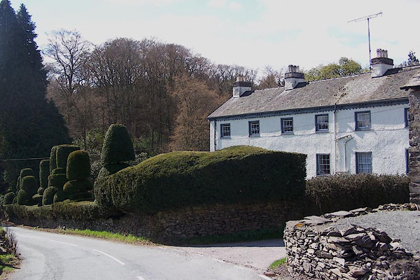 BLZ46.jpg (taken 28.4.2006) |
||
|
|
||
| evidence:- | old map:- OS County Series (Lan 8 3) placename:- Graythwaite Old Hall |
|
| source data:- | Maps, County Series maps of Great Britain, scales 6 and 25
inches to 1 mile, published by the Ordnance Survey, Southampton,
Hampshire, from about 1863 to 1948. |
|
|
|
||
| evidence:- | old map:- Crosthwaite 1783-94 (Win/Ble) placename:- Low Graithwaite |
|
| source data:- | Map, uncoloured engraving, An Accurate Map of the Grand Lake of
Windermere, scale about 2 inches to 1 mile, by Peter
Crosthwaite, Keswick, Cumberland, 1783, version published 1819.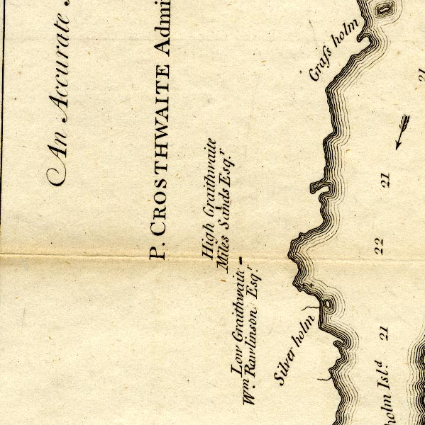 CT9SD39Q.jpg "Low Graithwaite / Wm. Rawlinson Esqr." block, building/s item:- Armitt Library : 2008.14.102 Image © see bottom of page |
|
|
|
||
| evidence:- | old text:- Clarke 1787 placename:- Low Grathwaite item:- garden; yew |
|
| source data:- | Guide book, A Survey of the Lakes of Cumberland, Westmorland,
and Lancashire, written and published by James Clarke, Penrith,
Cumberland, and in London etc, 1787; published 1787-93. goto source goto sourcePage 151:- "..." "... Grathwaite consists of two houses, called High and Low Grathwaite; ..." goto sourcePage 152:- "Low Grathwaite is the property of William Rawlinson, Esquire. Both these houses are very good modern buildings, and both the owners seem to have a great predilection for gardening; their situation is in a hollow circus, which disappoints them of viewing the Lake Winandermere. Mr Rawlinson has at one end of his garden a mount, underneath which is a cellar, and on the top a flower garden, surrounded with a fanciful yew hedge; this commands a pretty extensive view of the Lake through an opening in the woods. The houses are sheltered from the winds on every side, but are extremely hot in Summer; and as the descent to the Lake is steep and woody, the traveller will be agreeably surprized at his coming in view (suddenly) of these beautiful mansions, in the midst of wood and desart." |
|
|
|
||
| evidence:- | old map:- Clarke 1787 map (Windermere S) placename:- Grathwaite |
|
| source data:- | Map, A Map of the Southern Part of the Lake Winandermere and its
Environs, scale about 6.5 ins to 1 mile, by James Clarke,
engraved by Samuel John Neele, 352 Strand, published by James
Clarke, Penrith, Cumberland and in London etc, 1787.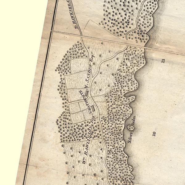 CLBSD39Q.jpg "GRATHWAITE / Wm. RAWLINSON Esqr." item:- private collection : 10.11 Image © see bottom of page |
|
|
|
||
| evidence:- | possibly old text:- Camden 1789 (Gough Additions) placename:- Graisdale |
|
| source data:- | Book, Britannia, or A Chorographical Description of the Flourishing Kingdoms of England,
Scotland, and Ireland, by William Camden, 1586, translated from the 1607 Latin edition
by Richard Gough, published London, 1789. goto source Page 143:- "From the antient family of Rawlinson of Graisdale descended sir Thomas Rawlinson, lord mayor of London, 1706, who died 1708, leaving eight of 15 children surviving. The eldest son Thomas was a man of learning and a patron of scholars and antiquaries, a great collector of books and MSS. which were sold after his death, 1725. 1733. The 4th son Richard was an eminent antiquary and great benefactor to the University of Oxford, where he had been educated at St. John's college, and was created LL.D. by diploma 1719 F.R. and A.S. and editor of various county histories, and other topographical pieces, compiler of the 'English Topographer, 1720.' 8vo. which suggested the plan of the 'British Topography,' in 2 vols. 4to. He died 1755, age 65, and was buried in a vault under St. Giles' church at Oxford, and his heart in his college chapel. His library of books was sold 1756 in 50 days, and his 20,000 pamphlets in 1757 in 10 days. ..." |
|
|
|
||
| evidence:- | possibly old map:- Otley 1818 placename:- Grathwaite |
|
| source data:- | Map, uncoloured engraving, The District of the Lakes,
Cumberland, Westmorland, and Lancashire, scale about 4 miles to
1 inch, by Jonathan Otley, 1818, engraved by J and G Menzies,
Edinburgh, Scotland, published by Jonathan Otley, Keswick,
Cumberland, et al, 1833.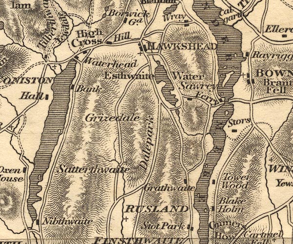 OT02SD39.jpg item:- JandMN : 48.1 Image © see bottom of page |
|
|
|
||
| evidence:- | old map:- Greenwood 1824 placename:- Old Hall |
|
| source data:- | Maps, Map of the County of Westmorland, scale about 1 inch to 1
mile, and Map of the County of Cumberland, scale about 1 inch to
1 mile, etc, by C and J Greenwood, published by George Pringle
jnr, 70 Queen Street, Cheapside, London, 1823 and 1824
respectively. "Old Hall" |
|
|
|
||
| evidence:- | old map:- Ford 1839 map placename:- How Hall |
|
| source data:- | Map, uncoloured engraving, Map of the Lake District of
Cumberland, Westmoreland and Lancashire, scale about 3.5 miles
to 1 inch, published by Charles Thurnam, Carlisle, and by R
Groombridge, 5 Paternoster Row, London, 3rd edn 1843.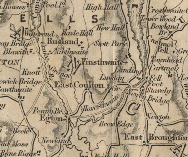 FD02SD38.jpg "How Hall" item:- JandMN : 100.1 Image © see bottom of page |
|
|
|
||
| evidence:- | probably old map:- Prior 1874 map 1 placename:- Graythwaite |
|
| source data:- | Map, uncoloured engraving or lithograph? Winander Mere, scale
about 2.5 miles to 1 inch, published by John Garnett,
Windermere, Westmorland, 1874.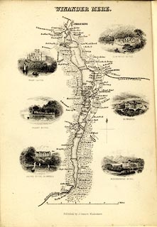 click to enlarge click to enlargePI03M1.jpg "Graythwaite" block/s; building/s item:- private collection : 133.1 Image © see bottom of page |
|
|
|
||
| evidence:- | old photograph:- Bell 1880s-1940s item:- antlers; sword; chair; court cupboard; press cupboard; fireback |
|
| source data:- | Photograph, b/w, the hall, Graythwaite Old Hall, Satterthwaite, Lancashire, by Herbert
Bell, Ambleside, Westmorland, 1890s?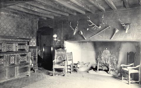 click to enlarge click to enlargeHB0335.jpg item:- Armitt Library : ALPS695 Image © see bottom of page |
|
|
|
||
| evidence:- | old photograph:- Bell 1880s-1940s item:- fireback |
|
| source data:- | Photograph, b/w, fireback at Graythwaite Old Hall, Satterthwaite, Lancashire, by Herbert
Bell, Ambleside, Westmorland, 1890s?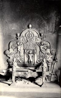 click to enlarge click to enlargeHB0336.jpg item:- Armitt Library : ALPS696 Image © see bottom of page |
|
|
|
||
| evidence:- | old photograph:- Bell 1880s-1940s |
|
| source data:- | Photograph, b/w, Graythwaite Old Hall, Satterthwaite, Lancashire, by Herbert Bell,
Ambleside, Westmorland, 1890s?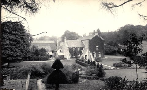 click to enlarge click to enlargeHB0337.jpg item:- Armitt Library : ALPS697 Image © see bottom of page |
|
|
|
||
| evidence:- | old photograph:- Bell 1880s-1940s |
|
| source data:- | Photograph, b/w, Graythwaite Old Hall, Satterthwaite, Lancashire, by Herbert Bell,
Ambleside, Westmorland, 1890s? click to enlarge click to enlargeHB0338.jpg item:- Armitt Library : ALPS698 Image © see bottom of page |
|
|
|
||
| evidence:- | database:- Listed Buildings 2010 placename:- Graythwaite Old Hall item:- court cupboard |
|
| source data:- | courtesy of English Heritage "GRAYTHWAITE OLD HALL / / / SATTERTHWAITE / SOUTH LAKELAND / CUMBRIA / II[star] / 76882 / SD3720290891" |
|
|
|
||
Lakes Guides menu.