 Old Cumbria Gazetteer
 |
 |
|
| included in:- |
 Karl Lofts, Shap probably Karl Lofts, Shap probably
|
|
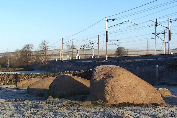
| Kemp Howe stone circle, Shap | ||
| Kemp Howe | ||
| Kemp Howe Stone Circle | ||
| Shap Stone Circle | ||
| locality:- | Shap | |
| civil parish:- | Shap (formerly Westmorland) | |
| county:- | Cumbria | |
| locality type:- | stone circle | |
| coordinates:- | NY56791330 | |
| 1Km square:- | NY5613 | |
| 10Km square:- | NY51 | |
| altitude:- | 869 feet | |
| altitude:- | 265m | |
|
|
||
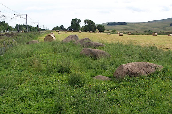 BJQ27.jpg (taken 13.7.2005) 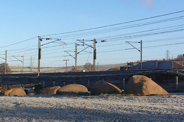 BLN10.jpg (taken 4.1.2006) |
||
|
|
||
| evidence:- | old map:- OS County Series (Wmd 21 2) placename:- Druidical Circle |
|
| source data:- | Maps, County Series maps of Great Britain, scales 6 and 25
inches to 1 mile, published by the Ordnance Survey, Southampton,
Hampshire, from about 1863 to 1948. "Druidical Circle (Remains of)" |
|
|
|
||
| evidence:- | old map:- Ogilby 1675 (plate 38) |
|
| source data:- | Road strip map, hand coloured engraving, continuation of the
Road from London to Carlisle, scale about 1 inch to 1 mile, by
John Ogilby, London, 1675.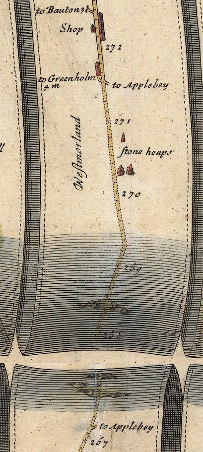 OG38m267.jpg In mile 270, Westmorland. "stone heaps" Three piles of stones, like cairns? drawn by the road. item:- JandMN : 21 Image © see bottom of page |
|
|
|
||
| evidence:- | probably old map:- Morden 1695 (Wmd) |
|
| source data:- | Map, hand coloured engraving, Westmorland, scale about 2.5 miles to 1 inch, by Robert
Morden, published by Abel Swale, the Unicorn, St Paul's Churchyard, Awnsham, and John
Churchill, the Black Swan, Paternoster Row, London, 1695.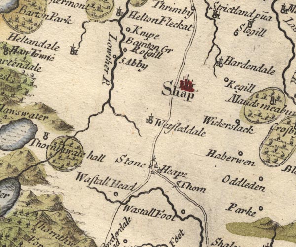 MD10NY51.jpg "Stone Heaps" Group of little tower symbols around the junction of the Kendal Shap road and Shap Orton road. item:- JandMN : 24 Image © see bottom of page |
|
|
|
||
| evidence:- | probably old map:- Bowen 1720 (plate 94) |
|
| source data:- | Strip maps, uncoloured engravings, road maps, The Road from
London to Carlisle, scale about 2 miles to 1 inch, with sections
in Lancashire and Westmorland, published by Emanuel Bowen, St
Katherines, London, 1720.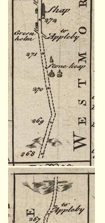 B094m267.jpg "Stone heap" 3 heaps of stones drawn on right, east, of road between mile 270 and 271. item:- Dove Cottage : 2007.38.100 Image © see bottom of page |
|
|
|
||
| evidence:- | probably old map:- Simpson 1746 map (Wmd) placename:- Stone Heaps |
|
| source data:- | Map, uncoloured engraving, Westmorland, scale about 8 miles to 1
inch, printed by R Walker, Fleet Lane, London, 1746.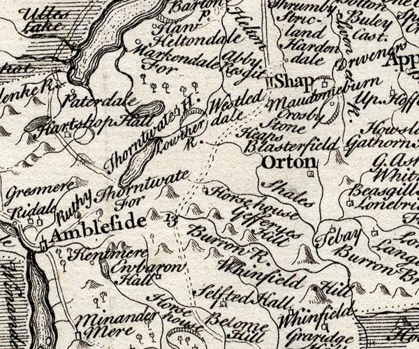 SMP2NYK.jpg "Stone Heaps" Near the road?. item:- Dove Cottage : 2007.38.59 Image © see bottom of page |
|
|
|
||
| evidence:- | possibly old map:- Bowen and Kitchin 1760 |
|
| source data:- | Map, hand coloured engraving, A New Map of the Counties of
Cumberland and Westmoreland Divided into their Respective Wards,
scale about 4 miles to 1 inch, by Emanuel Bowen and Thomas
Kitchin et al, published by T Bowles, Robert Sayer, and John
Bowles, London, 1760.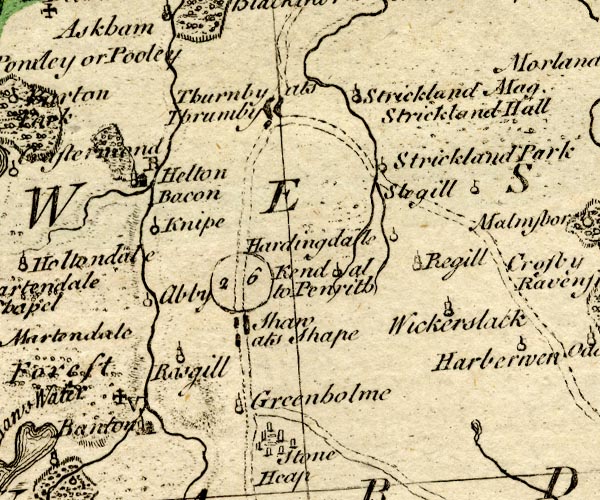 BO18NY41.jpg "Stone Heap" rough circle of standing stones item:- Armitt Library : 2008.14.10 Image © see bottom of page |
|
|
|
||
| evidence:- | descriptive text:- West 1778 (11th edn 1821) |
|
| source data:- | Guide book, A Guide to the Lakes, by Thomas West, published by
William Pennington, Kendal, Cumbria once Westmorland, and in
London, 1778 to 1821. goto source Page 174:- "... On the east side of the road, soon after you leave the village [Shap going S], observe a double range of" goto sourcePage 175:- "huge granites [1], pitched in the ground, and at some distance from each other, leading to circles of small stones, and increasing the space between the rows as they approach the circles, where the avenue is about 27 paces wide. They are supposed to have run quite through the village, and terminated in a point. It has long embarrassed the antiquaries what to call this very uncommon monument of ancient date. Mr. Pennant has given a plausible explanation of it from Olaus Magnus, and supposes the row of granites to be the recording stones of a Danish victory obtained on the spot, and the stony circles to be grateful tributes to the memory of consanguineous heroes slain in the action." "..." "[1] Since the inclosure of the common, many of these stones have been destroyed, for the purpose of making fence-walls." |
|
|
|
||
| evidence:- | descriptive text:- Ford 1839 (3rd edn 1843) |
|
| source data:- | Guide book, A Description of Scenery in the Lake District, by
Rev William Ford, published by Charles Thurnam, Carlisle, by W
Edwards, 12 Ave Maria Lane, Charles Tilt, Fleet Street, William
Smith, 113 Fleet Street, London, by Currie and Bowman,
Newcastle, by Bancks and Co, Manchester, by Oliver and Boyd,
Edinburgh, and by Sinclair, Dumfries, 1839. goto source Page 141:- "..." "... Karl Lofts, composed of two lines of huge unhewn masses of granite, ... having at its south end a circle of similar stones, eighteen feet in diameter, ..." |
|
|
|
||
| evidence:- | old text:- Gents Mag item:- vandalism |
|
| source data:- | Magazine, The Gentleman's Magazine or Monthly Intelligencer or
Historical Chronicle, published by Edward Cave under the
pseudonym Sylvanus Urban, and by other publishers, London,
monthly from 1731 to 1922. goto source Gentleman's Magazine 1844 part 2 opp p.381  click to enlarge click to enlargeG844E01.jpg "DRUIDICAL TEMPLE NEAR SHAP, WESTMORLAND" |
|
|
|
||
| evidence:- | old text:- Gents Mag 1844 |
|
| source data:- | goto source Gentleman's Magazine 1844 part 2 p.381 "Druidical Temple near Shap." "MR. URBAN," "NOTWITHSTANDING the alleged increase in good taste at the present day, I find it is the intention of the projectors of the Lancaster and Carlisle Railway to carry their line through, and destroy, a most interesting remnant of antiquity, the remains of a Druidical Temple situated in a field the property of the earl of Lonsdale, on the road from Kendal to Shap, and about 2 miles from the latter place. I am surprised that the noble Earl should permit such barbarity, with such influence as he possesses over the Company." "The accompanying sketch (Plate II.) of this curious monument, which will probably be in a very short time no longer in existence, may be interesting to your readers. It consists of 13 stones of Shap granite, the largest of which is 7 or 8 feet high, placed on a circle about forty feet in diameter." "Yours, &c." "DRUID." |
|
|
|
||
| evidence:- | old map:- LMS 1920s maps |
|
| source data:- | Railway map, lithograph, 23 pages of strip maps, The Journey in
Brief, the Route London to Carlisle, published by the London
Midland and Scottish Railway, LMS, 1920s.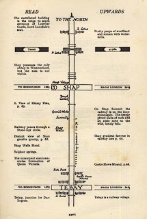 click to enlarge click to enlargeLS3p27.jpg "Druid Circle" Half a circle is shown, cut by the line of the railway. item:- JandMN : 95.2 Image © see bottom of page |
|
|
|
||
 BLN11.jpg (taken 4.1.2006) |
||
|
|
||
| hearsay:- |
6 granite bouilders are all that is left; the circle was destroyed by railway building
in the 19th century. THis is the southern end of Carls Lofts avenue. |
|
| Waterhouse, John: 1985: Stone Circles of Cumbria: Phillimore and Co (Chichester, Sussex)::
ISBN 0 85033 566 3 Burl, H A W: 1976: Stone Circles of the British Isles: Yale University Press (United States) |
||
|
|
||
| notes:- |
Several maps, perhaps copied from one to another, show 'Stone Heaps' at the junction
of the road to Orton and the Kendal Shap road. This is not exactly where the stone
circle is, but, has the road layout changed? |
|
|
|
||
Lakes Guides menu.