 Old Cumbria Gazetteer
 |
 |
|
| Lowther Bridge, Yanwath etc | ||
| Lowther Bridge | ||
| site name:- | Lowther, River | |
| locality:- | Bradwath (?) | |
| civil parish:- | Yanwath and Eamont Bridge (formerly Westmorland) | |
| civil parish:- | Clifton (formerly Westmorland) | |
| county:- | Cumbria | |
| locality type:- | bridge | |
| coordinates:- | NY52462820 | |
| 1Km square:- | NY5228 | |
| 10Km square:- | NY52 | |
|
|
||
| MN photo:- |
The bridge is widened in recent times, with ugly parapets, perhaps hiding a more interesting
old structure; access to see it is difficult. |
|
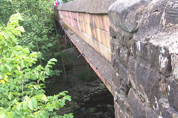 BMP14.jpg (taken 4.9.2006) |
||
|
|
||
| evidence:- | old map:- OS County Series (Wmd 3 16) placename:- Lowther Bridge |
|
| source data:- | Maps, County Series maps of Great Britain, scales 6 and 25
inches to 1 mile, published by the Ordnance Survey, Southampton,
Hampshire, from about 1863 to 1948. |
|
|
|
||
| evidence:- | old map:- Saxton 1579 |
|
| source data:- | Map, hand coloured engraving, Westmorlandiae et Cumberlandiae Comitatus ie Westmorland
and Cumberland, scale about 5 miles to 1 inch, by Christopher Saxton, London, engraved
by Augustinus Ryther, 1576, published 1579-1645.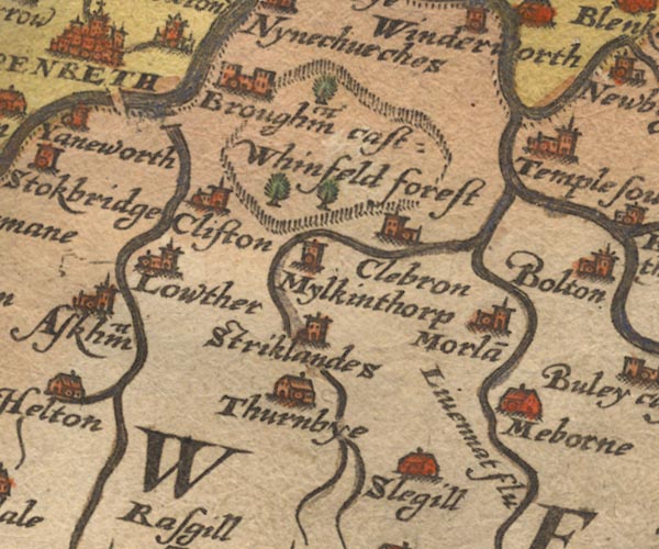 Sax9NY52.jpg Over River Lowther. item:- private collection : 2 Image © see bottom of page |
|
|
|
||
| evidence:- | old map:- Ogilby 1675 (plate 38) |
|
| source data:- | Road strip map, hand coloured engraving, continuation of the
Road from London to Carlisle, scale about 1 inch to 1 mile, by
John Ogilby, London, 1675.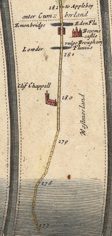 OG38m277.jpg In mile 281, Westmorland. Road crosses the:- "Lowder Fluvius" no bridge drawn. item:- JandMN : 21 Image © see bottom of page |
|
|
|
||
| evidence:- | old map:- Morden 1695 (Wmd) |
|
| source data:- | Map, hand coloured engraving, Westmorland, scale about 2.5 miles to 1 inch, by Robert
Morden, published by Abel Swale, the Unicorn, St Paul's Churchyard, Awnsham, and John
Churchill, the Black Swan, Paternoster Row, London, 1695.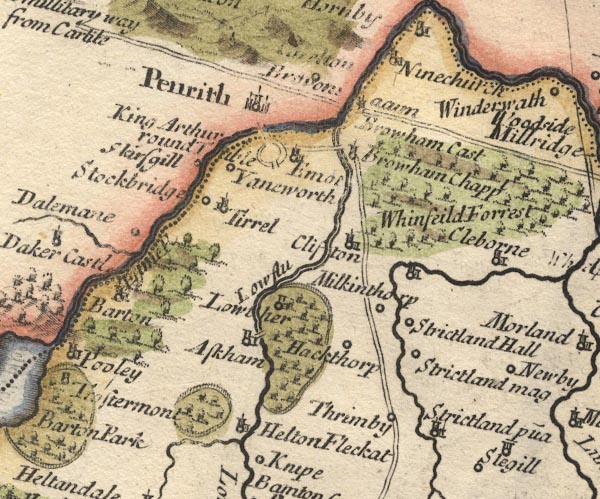 MD10NY52.jpg Double line over a stream. item:- JandMN : 24 Image © see bottom of page |
|
|
|
||
| evidence:- | descriptive text:- Defoe 1724-26 placename:- Louther Bridge |
|
| source data:- | Tour through England and Wales, by Daniel Defoe, published in
parts, London, 1724-26. "... the great road leads to the left-hand to Perith, in going to which we first pass the Eden, at a very good stone bridge call'd Louther Bridge, and then the Elnot over another." |
|
|
|
||
| evidence:- | old map:- Bowen and Kitchin 1760 |
|
| source data:- | Map, hand coloured engraving, A New Map of the Counties of
Cumberland and Westmoreland Divided into their Respective Wards,
scale about 4 miles to 1 inch, by Emanuel Bowen and Thomas
Kitchin et al, published by T Bowles, Robert Sayer, and John
Bowles, London, 1760.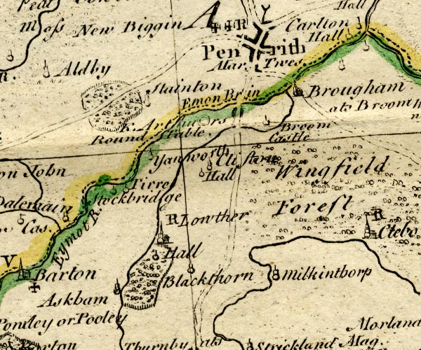 BO18NY42.jpg road across the Lowther item:- Armitt Library : 2008.14.10 Image © see bottom of page |
|
|
|
||
| evidence:- | old map:- Donald 1774 (Cmd) |
|
| source data:- | Map, hand coloured engraving, 3x2 sheets, The County of Cumberland, scale about 1
inch to 1 mile, by Thomas Donald, engraved and published by Joseph Hodskinson, 29
Arundel Street, Strand, London, 1774.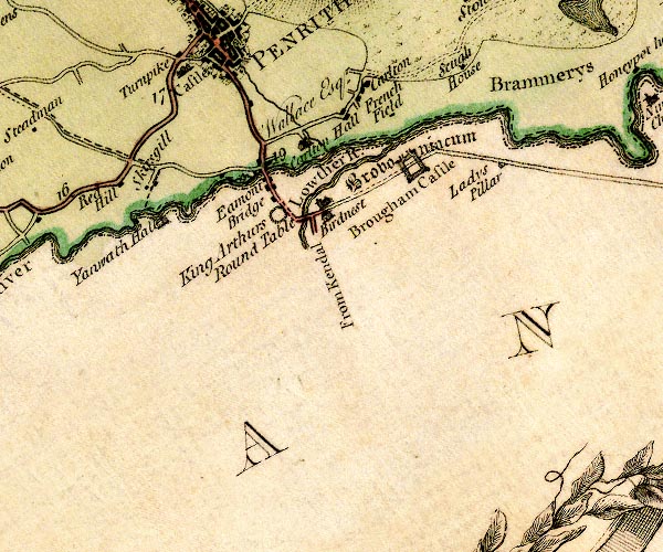 D4NY52NW.jpg double line across a river; a bridge item:- Carlisle Library : Map 2 Image © Carlisle Library |
|
|
|
||
| evidence:- | old text:- Clarke 1787 placename:- Lowther Bridge |
|
| source data:- | Guide book, A Survey of the Lakes of Cumberland, Westmorland,
and Lancashire, written and published by James Clarke, Penrith,
Cumberland, and in London etc, 1787; published 1787-93. goto source goto sourcePage 6:- "..." "We next come to Lowther Bridge, built over the river Lowther at a place called Bradwath in the boundary-rolls both of the manor of Brougham and Clifton. I am in possession of an old boundary-roll (taken at the perambulation of Gilbert de Engayne, in the 21st year of Edward III. at which time he settled the whole village of Clifton upon his son Henry, and Johanna his wife) and this likewise begins at Bradwath. This bridge likewise divides the parish of Brougham from the parish of Barton." "..." |
|
|
|
||
| evidence:- | road book:- Cary 1798 (2nd edn 1802) placename:- Lowther Bridge |
|
| source data:- | Road book, itineraries, Cary's New Itinerary, by John Cary, 181
Strand, London, 2nd edn 1802. goto source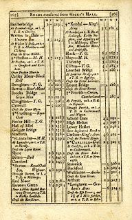 click to enlarge click to enlargeC38267.jpg page 267-268 "Lowther Bridge / At Lowther Bridge, on r. a T.R. to Appleby." goto source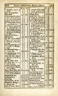 click to enlarge click to enlargeC38281.jpg page 281-282 "Lowther Bridge / At Lowther Bridge, on l. a T.R. to Kendal." item:- JandMN : 228.1 Image © see bottom of page |
|
|
|
||
| evidence:- | descriptive text:- Baker 1802 placename:- Lowther Bridge |
|
| source data:- | Perspective road map with sections in Lancashire, Westmorland,
and Cumberland, by J Baker, London 1802. pp.25-26:- "... At Lowther Bridge the rivers Emmont and Lowther form a junction. ..." |
|
|
|
||
| evidence:- | possibly old map:- Baker 1802 placename:- Lowther Bridge |
|
| source data:- | Perspective road maps with sections in Lancashire, Westmorland
and Cumberland, by J Baker, London 1802. Bk03Vg06.jpg "Lowther Bridge / 285" item:- private collection : 3 Image © see bottom of page |
|
|
|
||
| evidence:- | old map:- Laurie and Whittle 1806 placename:- Lowther Bridge |
|
| source data:- | Road map, Completion of the Roads to the Lakes, scale about 10
miles to 1 inch, by Nathaniel Coltman? 1806, published by Robert
H Laurie, 53 Fleet Street, London, 1834. click to enlarge click to enlargeLw18.jpg "Lowther Bridge 286¼" bridge; distance from London item:- private collection : 18.18 Image © see bottom of page |
|
|
|
||
| evidence:- | old map:- Cooper 1808 |
|
| source data:- | Map, hand coloured engraving, Westmoreland ie Westmorland, scale
about 9 miles to 1 inch, by H Cooper, 1808, published by R
Phillips, Bridge Street, Blackfriars, London, 1808. click to enlarge click to enlargeCOP4.jpg road across stream; bridge? item:- Dove Cottage : 2007.38.53 Image © see bottom of page |
|
|
|
||
| evidence:- | old map:- Otley 1818 |
|
| source data:- | Map, uncoloured engraving, The District of the Lakes,
Cumberland, Westmorland, and Lancashire, scale about 4 miles to
1 inch, by Jonathan Otley, 1818, engraved by J and G Menzies,
Edinburgh, Scotland, published by Jonathan Otley, Keswick,
Cumberland, et al, 1833. OT02NY52.jpg Implied by a road across the stream. item:- JandMN : 48.1 Image © see bottom of page |
|
|
|
||
| evidence:- | old text:- Gents Mag item:- rebellion, 1745; 1745 Rebellion |
|
| source data:- | Magazine, The Gentleman's Magazine or Monthly Intelligencer or
Historical Chronicle, published by Edward Cave under the
pseudonym Sylvanus Urban, and by other publishers, London,
monthly from 1731 to 1922. goto source Gentleman's Magazine 1848 part 1 p.369 "... the celebrated and no less picturesque bridge of Lowther, so well known as the spot where Cluny Macpherson engaged the advanced guard of the Duke of Cumberland in 1745, and brought off the artillery belonging to the Highland army." |
|
|
|
||
Lakes Guides menu.