 Old Cumbria Gazetteer
 |
 |
|
| Mallerstang Forest, Mallerstang | ||
| Mallerstang Forest | ||
| locality:- | Mallerstang | |
| civil parish:- | Mallerstang (formerly Westmorland) | |
| civil parish:- | Ravenstonedale (formerly Westmorland) | |
| county:- | Cumbria | |
| locality type:- | forest | |
| 10Km square:- | NY70 (?) | |
| 10Km square:- | SD79 (?) | |
| 1Km square:- | NY7000 | |
| 10Km square:- | NY70 | |
| 10Km square:- | SD79 | |
| SummaryText:- | Perhaps now Mallerstang Common? | |
|
|
||
| evidence:- | old map:- Saxton 1579 placename:- Mallestange Forest |
|
| source data:- | Map, hand coloured engraving, Westmorlandiae et Cumberlandiae Comitatus ie Westmorland
and Cumberland, scale about 5 miles to 1 inch, by Christopher Saxton, London, engraved
by Augustinus Ryther, 1576, published 1579-1645.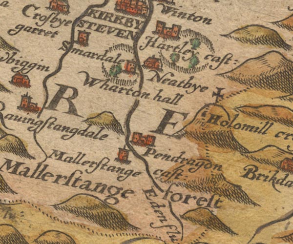 Sax9NY70.jpg "Mallestange forest" No trees. item:- private collection : 2 Image © see bottom of page |
|
|
|
||
| evidence:- | perhaps old map:- Speed 1611 (Cum/EW) |
|
| source data:- | Map, hand coloured engraving, Kingdome of Great Britaine and
Ireland, scale about 36 miles to 1 inch, by John Speed, about
1610-11, published by Thomas Bassett, Fleet Street and Richard
Chiswell, St Paul's Churchyard, London, 1676?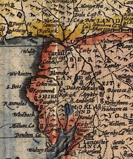 click to enlarge click to enlargeSPD6Cm.jpg a tree item:- private collection : 85 Image © see bottom of page |
|
|
|
||
| evidence:- | old map:- Speed 1611 (Wmd) placename:- Mallerstang Forest |
|
| source data:- | Map, hand coloured engraving, The Countie Westmorland and
Kendale the Cheif Towne, scale about 2.5 miles to 1 inch, by
John Speed, 1610, published by George Humble, Popes Head Alley,
London, 1611-12.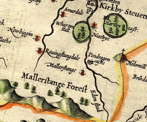 SP14NY70.jpg "Mallerstang Forest" group of tree symbols, north of a range of hillocks item:- Armitt Library : 2008.14.5 Image © see bottom of page |
|
|
|
||
| evidence:- | poem:- Drayton 1612/1622 text placename:- Malerstrang |
|
| source data:- | Poem, Poly Olbion, by Michael Drayton, published by published by
John Marriott, John Grismand and Thomas Dewe, and others?
London, part 1 1612, part 2 1622. goto source goto sourcepage 162:- "... ... Eden making on, Through Malerstrang hard by, a Forrest woe begone In love with Edens eyes, of the cleere Naiades kind, Whom thus the Wood-Nymph greets: What passage thou shalt find, My most beloved Brook, in making to thy Bay, That wandring art to wend through many a crooked way, Farre under hanging Hills, through many a cragged strait, And few the watry kind, upon thee to await, Opposed in thy course with many a rugged Cliffe, Besides the Northern winds against thy stream to stiffe, As by maine strength they meant to stop thee in thy course, And send the easly back to Morvill to thy source. O my bright lovely Brooke, whose name doth beare the sound Of Gods first Garden-plot, th'imparadized ground, Wherein he placed Man, from whence by sinne he fell. O little blessed Brooke, how doth my bosome swell, / With" goto sourcepage 163:- "With love I beare to thee, the day cannot suffice For Malerstrang to gaze upon thy beautious eyes." "This say'd, the Forrest rubd her rugged front the while, Cleere Eden looking back, regrets her with a smile, ..." |
|
|
|
||
| evidence:- | old map:- Drayton 1612/1622 placename:- Mallerstrang Forest |
|
| source data:- | Map, hand coloured engraving, Cumberlande and Westmorlande, by
Michael Drayton, probably engraved by William Hole, scale about
4 or 5 miles to 1 inch, published by John Mariott, John
Grismand, and Thomas Dewe, London, 1622.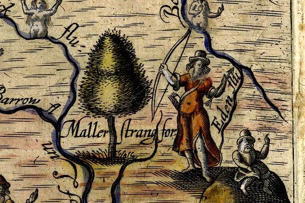 DRY525.jpg "Mallerstrang for" Tree, huntress with a bow and arrows. item:- JandMN : 168 Image © see bottom of page |
|
|
|
||
| evidence:- | old map:- Jansson 1646 placename:- Mallerstange Forest |
|
| source data:- | Map, hand coloured engraving, Cumbria and Westmoria, ie
Cumberland and Westmorland, scale about 3.5 miles to 1 inch, by
John Jansson, Amsterdam, Netherlands, 1646.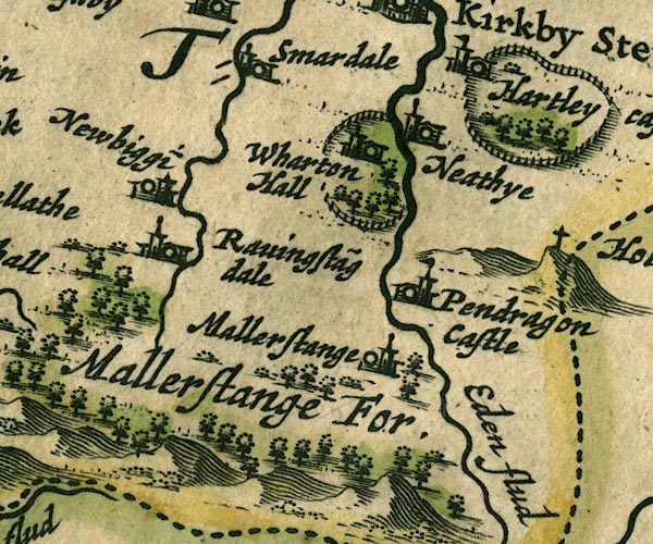 JAN3NY70.jpg "Mallerstange For." Group of tree symbols. item:- JandMN : 88 Image © see bottom of page |
|
|
|
||
| evidence:- | old map:- Seller 1694 (Wmd) placename:- Marllerstange Forest |
|
| source data:- | Map, hand coloured engraving, Westmorland, scale about 8 miles
to 1 inch, by John Seller, 1694. click to enlarge click to enlargeSEL7.jpg "Marllerstange forest" area item:- Dove Cottage : 2007.38.87 Image © see bottom of page |
|
|
|
||
| evidence:- | old map:- Morden 1695 (Wmd) placename:- Mallerstang Forrest |
|
| source data:- | Map, hand coloured engraving, Westmorland, scale about 2.5 miles to 1 inch, by Robert
Morden, published by Abel Swale, the Unicorn, St Paul's Churchyard, Awnsham, and John
Churchill, the Black Swan, Paternoster Row, London, 1695.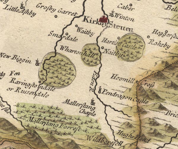 MD10NY70.jpg "Mallerstang Forrest" Trees. item:- JandMN : 24 Image © see bottom of page |
|
|
|
||
| evidence:- | descriptive text:- Defoe 1724-26 placename:- Mallerstang Forest |
|
| source data:- | Tour through England and Wales, by Daniel Defoe, published in
parts, London, 1724-26. "... the River Lune, which is the boundary of the county, and leaves the hills of Mallerstang Forest, which are, in many places, unpassable. ..." |
|
|
|
||
| evidence:- | descriptive text:- Simpson 1746 placename:- Mallerstrand Forest |
|
| source data:- | Atlas, three volumes of maps and descriptive text published as
'The Agreeable Historian, or the Compleat English Traveller
...', by Samuel Simpson, 1746. goto source Page 1020:- "..." "... the Lone or Lune, which rising near Mallerstrand Forest, not far from Rissendale, ..." |
|
|
|
||
| evidence:- | old map:- Simpson 1746 map (Wmd) placename:- Mallerstang Forrest |
|
| source data:- | Map, uncoloured engraving, Westmorland, scale about 8 miles to 1
inch, printed by R Walker, Fleet Lane, London, 1746.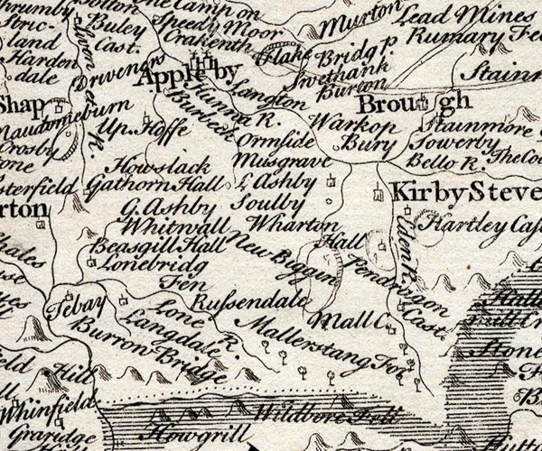 SMP2NYQ.jpg "Mallerstang For" Tree symbols. item:- Dove Cottage : 2007.38.59 Image © see bottom of page |
|
|
|
||
| evidence:- | old map:- Bowen and Kitchin 1760 placename:- Mallerstang Forest |
|
| source data:- | Map, hand coloured engraving, A New Map of the Counties of
Cumberland and Westmoreland Divided into their Respective Wards,
scale about 4 miles to 1 inch, by Emanuel Bowen and Thomas
Kitchin et al, published by T Bowles, Robert Sayer, and John
Bowles, London, 1760.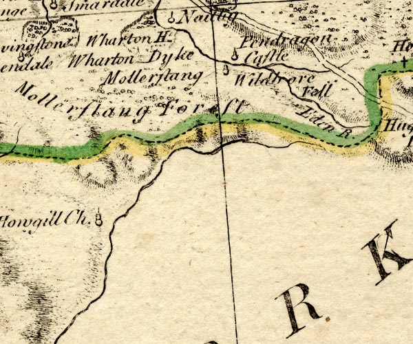 BO18NY70.jpg "Mallerstang Forest" bushes item:- Armitt Library : 2008.14.10 Image © see bottom of page |
|
|
|
||
| evidence:- | old map:- Jefferys 1770 (Wmd) placename:- Mallerstang Forest |
|
| source data:- | Map, 4 sheets, The County of Westmoreland, scale 1 inch to 1
mile, surveyed 1768, and engraved and published by Thomas
Jefferys, London, 1770.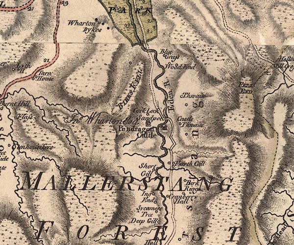 J5NY70SE.jpg 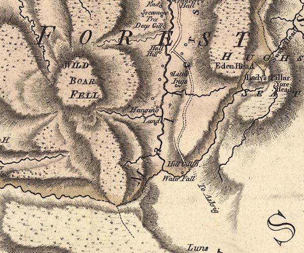 J5SD79NE.jpg "MALLERSTANG FOREST" area item:- National Library of Scotland : EME.s.47 Images © National Library of Scotland |
|
|
|
||
| evidence:- | old map:- Cary 1789 (edn 1805) placename:- Mallerstang Forest |
|
| source data:- | Map, uncoloured engraving, Westmoreland, scale about 2.5 miles
to 1 inch, by John Cary, London, 1789; edition 1805.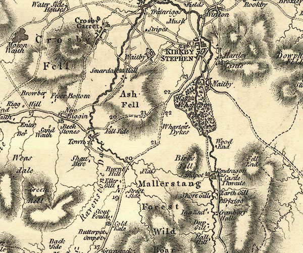 CY24NY70.jpg "Mallerstang Forest" area item:- JandMN : 129 Image © see bottom of page |
|
|
|
||
Lakes Guides menu.