 Old Cumbria Gazetteer
 |
 |
|
| Mellbreak, Loweswater | ||
| Mellbreak | ||
| civil parish:- | Loweswater (formerly Cumberland) | |
| county:- | Cumbria | |
| locality type:- | hill | |
| coordinates:- | NY14451905 (etc) | |
| 1Km square:- | NY1419 | |
| 10Km square:- | NY11 | |
|
|
||
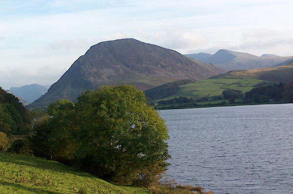
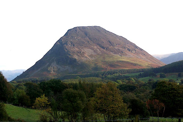 BJY15.jpg From Thrushbank. (taken 14.10.2005) 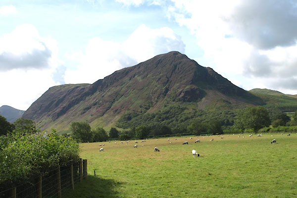 BVE93.jpg (taken 17.8.2011) |
||
|
|
||
| evidence:- | old map:- Gents Mag 1751 placename:- Mell Break |
|
| source data:- | Map, uncoloured engraving, Map of the Black Lead Mines in
Cumberland, and area, scale about 2 miles to 1 inch, by George
Smith, published in the Gentleman's Magazine, 1751.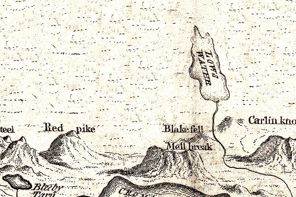 GM1302.jpg "Mell break" knobbly hillocks; mountains item:- JandMN : 114 Image © see bottom of page |
|
|
|
||
| evidence:- | old map:- Donald 1774 (Cmd) placename:- Mellbreak |
|
| source data:- | Map, hand coloured engraving, 3x2 sheets, The County of Cumberland, scale about 1
inch to 1 mile, by Thomas Donald, engraved and published by Joseph Hodskinson, 29
Arundel Street, Strand, London, 1774.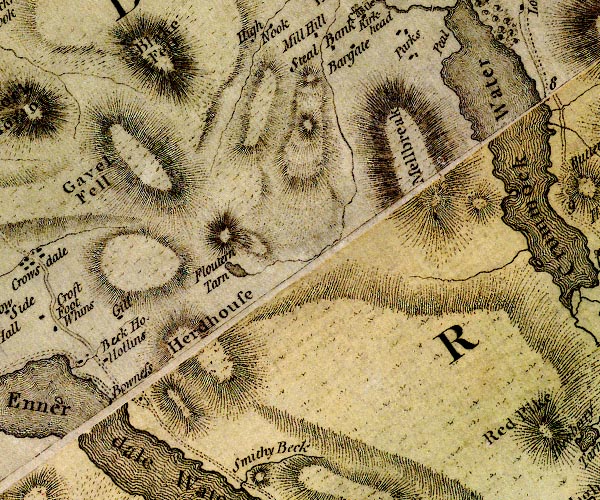 D4NY11NW.jpg "Mellbreak" hill hachuring; a hill or mountain item:- Carlisle Library : Map 2 Image © Carlisle Library |
|
|
|
||
| evidence:- | old map:- Crosthwaite 1783-94 (But/Cru/Low) placename:- Melbreak |
|
| source data:- | Map, uncoloured engraving, An Accurate Map of Buttermere,
Crummock and Loweswater Lakes, scale about 3 inches to 1 mile,
by Peter Crosthwaite, Keswick, Cumberland, 1794, version
published 1800.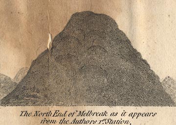 CT08Vgn4.jpg "The North End of Melbreak as it appears from the Author's 1st. Station." item:- Armitt Library : 1959.191.2 Image © see bottom of page |
|
|
|
||
| evidence:- | old map:- West 1784 map placename:- Mellbreak |
|
| source data:- | Map, hand coloured engraving, A Map of the Lakes in Cumberland,
Westmorland and Lancashire, scale about 3.5 miles to 1 inch,
engraved by Paas, 53 Holborn, London, about 1784. Ws02NY11.jpg item:- Armitt Library : A1221.1 Image © see bottom of page |
|
|
|
||
| evidence:- | old text:- Green 1814 placename:- Melbreak |
|
| source data:- | Set of prints, soft ground etchings, Sixty Small Prints, with
text, A Description of a Series of Sixty Small Prints, by
William Green, Ambleside, Westmorland, 1814. goto source goto sourcepage 22:- "..." "Melbreak, Whiteside, Grasmire, Rannerdale Knott, and Honister Crag are fine objects when seen from the head of Low's Water. ..." |
|
|
|
||
| evidence:- | old map:- Otley 1818 placename:- Melbreak |
|
| source data:- | Map, uncoloured engraving, The District of the Lakes,
Cumberland, Westmorland, and Lancashire, scale about 4 miles to
1 inch, by Jonathan Otley, 1818, engraved by J and G Menzies,
Edinburgh, Scotland, published by Jonathan Otley, Keswick,
Cumberland, et al, 1833. OT02NY11.jpg item:- JandMN : 48.1 Image © see bottom of page |
|
|
|
||
| evidence:- | old print:- Fielding and Walton 1821 (plate 32) |
|
| source data:- | Print, coloured aquatint, Lowes Water, Cumberland, drawn by Theodore H A Fielding,
published by R Ackermann, 101 Strand, London, 1821.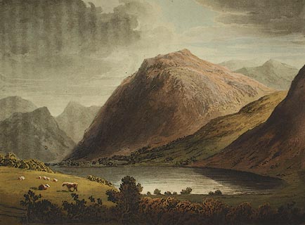 click to enlarge click to enlargeFW0132.jpg Mellbreak dominating the lake. Tipped in opposite p.215 in A Picturesque Tour of the English Lakes. item:- Dove Cottage : 1993.R566.32 Image © see bottom of page |
|
|
|
||
| evidence:- | outline view:- Otley 1823 (4th edn 1830) placename:- Melbreak |
|
| source data:- | Print, engraving, outline view, The Mountains of Crummock and Buttermere as seen on
the Road between Scale-Hill and Loweswater, published by Jonathan Otley, Keswick,
Cumberland et al, 1830.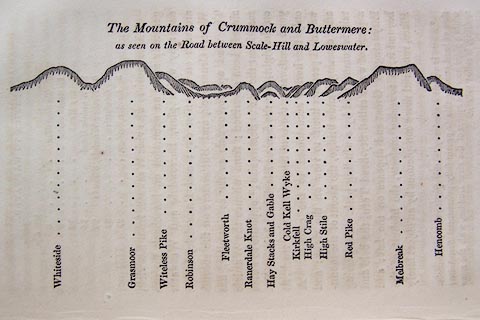 click to enlarge click to enlargeO75E07.jpg p.125 in A Concise Description of the English Lakes, by Jonathan Otley, 4th edition, 1830. "The Mountains of Crummock and Buttermere: / as seen on the Road between Scale-Hill and Loweswater." "Whiteside / Grasmoor / Witeless Pike / Robinson / Fleetworth / Rannerdale Knot / Hay Stacks and Gable / Cold Kell Wyke / Kirkfell / High Crag / High Stile / Red Pike / Melbreak / Hencomb" item:- Armitt Library : A1175.7 Image © see bottom of page |
|
|
|
||
| evidence:- | outline view:- Otley 1823 (8th edn 1849) placename:- Melbreak |
|
| source data:- | Engraving, outline view of mountains, Crummock and Buttermere from the Road near Loweswater
Church, drawn by T Binns, engraved by O Jewitt, opposite p.18 of A Descriptive Guide
of the English Lakes, by Jonathan Otley, 8th edition, 1849.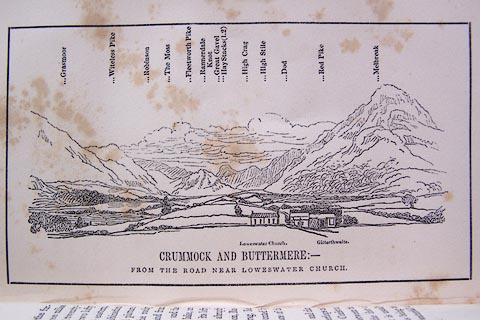 click to enlarge click to enlargeO80E10.jpg item:- Armitt Library : A1180.11 Image © see bottom of page |
|
|
|
||
| evidence:- | outline view:- Otley 1823 (8th edn 1849) placename:- Melbreak |
|
| source data:- | Engraving, outline view of mountains, A Group of Mountains seen from Helvellyn, looking
towards the South West, drawn by T Binns, engraved by O Jewitt, opposite p.50 of A
Descriptive Guide of the English Lakes, by Jonathan Otley, 8th edition, 1849.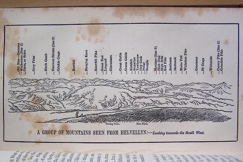 click to enlarge click to enlargeO80E17.jpg item:- Armitt Library : A1180.18 Image © see bottom of page |
|
|
|
||
| evidence:- | outline view:- Otley 1823 (5th edn 1834) placename:- Melbreak |
|
| source data:- | Print, woodcut outline view, The Mountains of Crummock and
Buttermere, by Jonathan Otley, Keswick, Cumberland, 1830.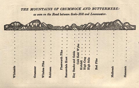 click to enlarge click to enlargeOT2E05.jpg Printed on p.25 of A Concise Description of the English Lakes, by Jonathan Otley, 5th edition, 1834. "THE MOUNTAINS OF CRUMMOCK AND BUTTERMERE: as seen on the Road between Scale-Hill and Loweswater." "Whiteside / Grasmoor / Witeless Pike / Robinson / Fleetworth Pike / Rannerdale Knot / Hay Stacks and Gable / Cold Keld Wyke / Kirkfell / High Crag / High Stile / Red Pike / Melbreak / Hencomb" item:- JandMN : 48.6 Image © see bottom of page |
|
|
|
||
| evidence:- | old map:- Garnett 1850s-60s H placename:- Melbreak |
|
| source data:- | Map of the English Lakes, in Cumberland, Westmorland and
Lancashire, scale about 3.5 miles to 1 inch, published by John
Garnett, Windermere, Westmorland, 1850s-60s. GAR2NY11.jpg "Melbreak" hill hachuring item:- JandMN : 82.1 Image © see bottom of page |
|
|
|
||
| evidence:- | old print with text:- Pyne 1853 |
|
| source data:- | Print, tinted lithograph, Lowes Water, Cumberland, by James Baker Pyne, engraved by
W Gauci, published by Thomas Agnew and Sons, Manchester, Lancashire, 1853.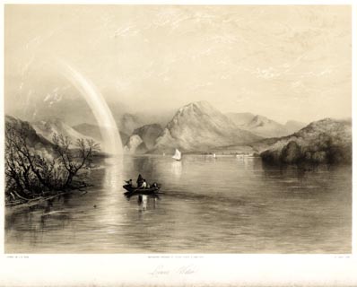 click to enlarge click to enlargePYN222.jpg "PAINTED BY J. B. PYNE. / W. GAUCI LITH. / MANCHESTER, PUBLISHED BY THOMAS AGNEW & SONS, 1853. / Lowes Water / [M & N HANHART IMPT.]" From the descriptive text:- "... The tranquil lake gives back mountain forms in all their massive outline and richly-coloured truth. The fragmental bow across the heavens indicates a retiring shower. The rude boat floats as if magically suspended in mid air, so perfectly transparanet is the water. ..." item:- Armitt Library : A6678.23 Image © see bottom of page |
|
|
|
||
| evidence:- | old print:- Pyne 1853 |
|
| source data:- | Print, coloured lithograph, Lowes Water, Cumberland, by James Baker Pyne, engraved
by W Gauci, published by Thomas Agnew and Sons, Manchester, Lancashire, 1853.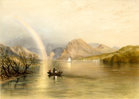 click to enlarge click to enlargePYN422.jpg item:- Armitt Library : A6677.23 Image © see bottom of page |
|
|
|
||
| evidence:- | outline view:- Martineau 1855 placename:- Melbreak |
|
| source data:- | Print, engraving, outline view, Mountains seen from Lanthwaite Wood Crummock Water,
drawn by L Aspland, engraved by W Banks, Edinburgh, published by John Garnett, Windermere,
Westmorland, and by Whittaker and Co, London, 1855.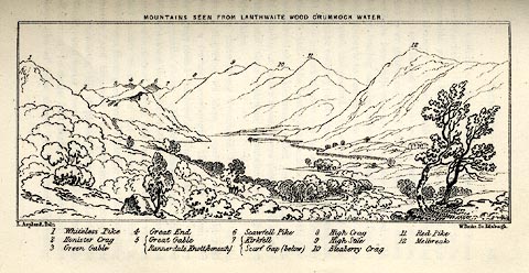 click to enlarge click to enlargeMNU113.jpg Opposite p.84 in A Complete Guide to the English Lakes, by Harriet Martineau. The view is captioned, numbers referring to mountains in the image:- "1 Whiteless Pike, 2 Honister Crag, 3 Green Gable, 4 Great End, 5 Great Gable / Rannerdale Knott (beneath), 6 Scawfell Pike, 7 Kirkfell / Scarf Gap (below), 8 High Crag, 9 High Stile, 10 Bleaberry Crag, 11 Red Pike, 12 Melbreak." "MOUNTAINS SEEN FROM LANTHWAITE WOOD CRUMMOCK WATER." "L Aspland Delt. / W Banks Sc Edinr." item:- Armitt Library : A1159.13 Image © see bottom of page |
|
|
|
||
| evidence:- | old text:- Martineau 1855 placename:- Melbreak |
|
| source data:- | Guide book, A Complete Guide to the English Lakes, by Harriet
Martineau, published by John Garnett, Windermere, Westmorland,
and by Whittaker and Co, London, 1855; published 1855-76. goto source Page 85:- "... Melbreak fills up the opposite shore, with its isolated bulk; ..." |
|
|
|
||
| evidence:- | outline view:- Martineau 1855 |
|
| source data:- | Print, engraving, outline view, Mountains seen from Applethwaite near Keswick, drawn
by L Aspland, engraved by W Banks, Edinburgh, published by John Garnett, Windermere,
Westmorland, and by Whittaker and Co, London, 1855.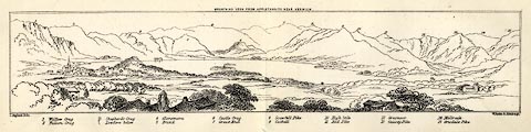 click to enlarge click to enlargeMNU114.jpg Folded in opposite p.93 in A Complete Guide to the English Lakes, by Harriet Martineau. "MOUNTAINS SEEN FROM APPLETHWAITE NEAR KESWICK." "L Aspland Delt. / W Banks Sc Edinr." The view is captioned, numbers referring to mountains in the image:- "1 Wallow Crag, 2 Falcon Crag, 3 Shepherd's Crag / Lowdore below, 4 Glaramara, 5 Brund, 6 Castle Crag, 7 Great End, 8 Scawfell Pike, 9 Catbell, 10, High Stile, 11 Red Pike, 12 Grasmoor, 13 Causey Pike, 14 Melbreak, 15 Grisdale Pike" item:- Armitt Library : A1159.14 Image © see bottom of page |
|
|
|
||
| evidence:- | old photograph:- Bell 1880s-1940s |
|
| source data:- | Photograph, black and white, Crummock Water and Mellbreak, Loweswater, Cumberland,
by Herbert Bell, Ambleside, Westmorland, 1890s.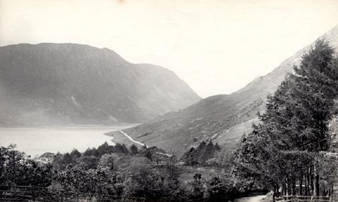 click to enlarge click to enlargeHB0465.jpg internegative at lower left:- "H. Bell" item:- Armitt Library : ALPS124 Image © see bottom of page |
|
|
|
||
| evidence:- | old photograph:- Marr 1916 placename:- Melbreak |
|
| source data:- | Photograph, halftone print, Melbreak and Loweswater, Loweswater, Cumberland, 1916.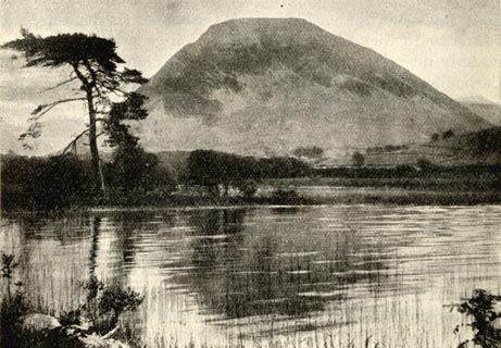 click to enlarge click to enlargeMA1201.jpg item:- JandMN : 173.9 Image © see bottom of page |
|
|
|
||
| evidence:- | outline view:- Jenkinson 1875 placename:- Mellbreak |
|
| source data:- | Print, lithograph, outline view, Panoramic Sketches from Helvellyn, Westmorland, by
Edwin A Pettitt, London, published by Edward Stanford, 55 Charing Cross, London, 1875.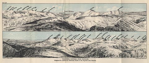 click to enlarge click to enlargeJk01E1.jpg "... Mellbreak ..." item:- JandMN : 28.5 Image © see bottom of page |
|
|
|
||
| evidence:- | outline view:- Black 1856 placename:- Mellbreak |
|
| source data:- | Print, lithograph, Outline Views, Buttermere - Mountains as seen from the Knots near
the Hotel at Buttermere, and Mountains as seen at the Seat in Lanthwaite Wood, Scale
Hill, by J Flintoft, Keswick, Cumberland, engraved by R Mason, Edinburgh, Lothian,
about 1900.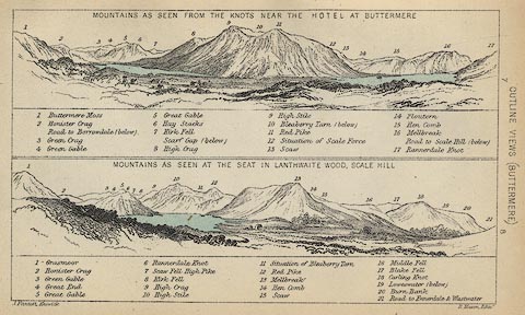 click to enlarge click to enlargeBC08E5.jpg "... 16 Mellbreak ... 13 Mellbreak ..." item:- JandMN : 37.19 Image © see bottom of page |
|
|
|
||
| evidence:- | perhaps old print:- Pyne 1853 |
|
| source data:- | Drawn by James Barker Pyne, 1848-1853, lithographed by T Picken, 1859.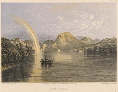 click to enlarge click to enlargePY19.jpg "Lowes Water" item:- JandMN : 97.18 Image © see bottom of page |
|
|
|
||
| evidence:- | outline view:- Black 1841 (3rd edn 1846) placename:- Mellbreak |
|
| source data:- | Print, engraving, outline view, Mountains as seen from The Knots near the Victoria
at Buttermere, and Mountains as seen at the Seat in Lanthwaite Wood, Scale Hill, by
J Flintoft, Keswick, Cumberland, engraved by R Mason, Edinburgh, Lothian, about 1846.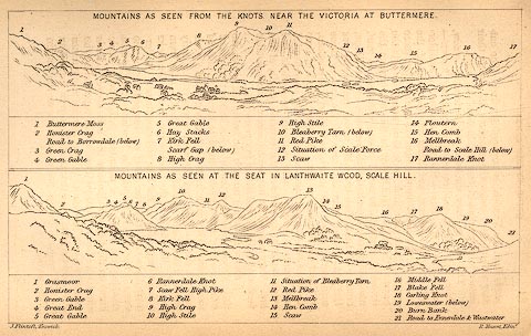 click to enlarge click to enlargeBC02E7.jpg "... 16 Mellbreak ... 13 Mellbreak ..." item:- JandMN : 32.11 Image © see bottom of page |
|
|
|
||
| evidence:- | outline view:- Tattersall 1836 (version 1869) placename:- Melbreak |
|
| source data:- | Print, hand coloured, Loweswater, from the North West, Cumberland, drawn by George
Tattersall, 1836, engraved by W F Topham, published by T J Allman, 463 Oxford Street,
London, 1869.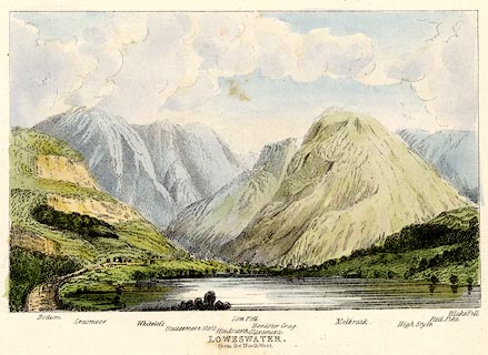 click to enlarge click to enlargeTAT216.jpg Included in The Lakes of England, by W F Topham. printed at bottom:- "LOWESWATER, / from the North West." printed at bottom:- "Bottom. / Grasmoor. / Whiteless. / Buttermere Moss. / Hindscarth. / Low Fell. / Glaramara. / Honister Crag. / Melbreak. / High Style. / Red Pike. / Blake Fell." item:- Armitt Library : A1067.16 Image © see bottom of page |
|
|
|
||
| evidence:- | outline view:- Tattersall 1836 (version 1869) placename:- Melbreak |
|
| source data:- | Print, hand coloured, Crummock Lake, from the East, Buttermere, Cumberland, drawn
by George Tattersall, 1836, engraved by W F Topham, published by T J Allman, 463 Oxford
Street, London, 1869.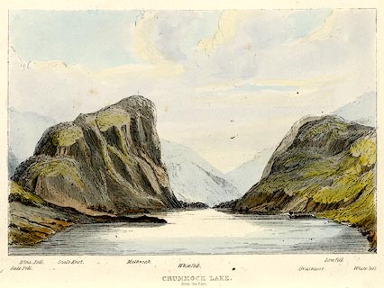 click to enlarge click to enlargeTAT211.jpg Included in The Lakes of England, by W F Topham. printed at bottom:- "CRUMMOCK LAKE, / from the East." printed at bottom:- "Gale Fell. / Blea Fell. / Scale Knot. / Melbreak. / Whinfell. / Grasmoor. / Low Fell. / Whiteless." item:- Armitt Library : A1067.11 Image © see bottom of page |
|
|
|
||
| evidence:- | outline view:- Tattersall 1836 placename:- Melbreak |
|
| source data:- | Print, engraving, Loweswater from the North West, Cumberland, drawn by George Tattersall,
engraved by W F Topham, published by Sherwood and Co, Paternoster Row, London, about
1836.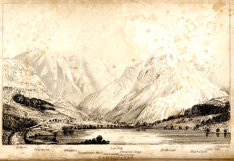 click to enlarge click to enlargeTAT134.jpg The print is captioned with mountain names and acts as an outline view. Frontispiece to The Lakes of England, by George Tattersall (listed to be inserted opposite p.35). printed at bottom:- "LOWESWATER. / from the North West." printed at bottom left to right:- "Bottom. / Grasmoor. / Whiteless. / Buttermere &Moss. / Hindscarth. / Low Fell. / Glaramara. / Honister Crag. / Melbreak. / High Style. / Red Pike. / Blake Fell." item:- Armitt Library : A1204.35 Image © see bottom of page |
|
|
|
||
| evidence:- | outline view:- Tattersall 1836 placename:- Melbreak |
|
| source data:- | Print, engraving, Crummock Lake, from the East, Buttermere, Cumberland, drawn by George
Tattersall, engraved by W F Topham, published by Sherwood and Co, Paternoster Row,
London, about 1836.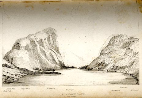 click to enlarge click to enlargeTAT128.jpg The print is captioned with mountain names and acts as an outline view. Tipped in opposite p.74 of The Lakes of England, by George Tattersall. printed at bottom:- "CRUMMOCK LAKE. / from the East." printed at bottom left to right:- "Gale Fell. / Blea Fell. / Scale Knot. / Melbreak. / Whinfell. / Grasmoor. / Lowfell. / Whiteless." item:- Armitt Library : A1204.29 Image © see bottom of page |
|
|
|
||
| evidence:- | old print:- Rose 1832-35 (vol.2 no.13) placename:- Mellbreak |
|
| source data:- | Print, engraving, Loweswater, from Water End, Cumberland, by Thomas Allom, engraved
by W Floyd, 1833.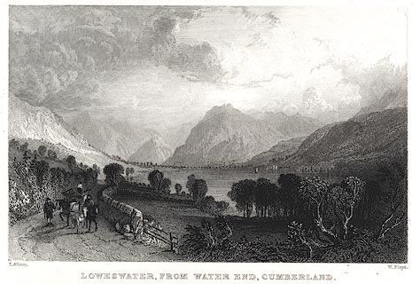 click to enlarge click to enlargePR0402.jpg The text description of the view it 'includes the mountains of Blake Fell, Mellbreak, and Red Pike.' Vol.2 no.13 in Westmorland, Cumberland, Durham and Northumberland Illustrated, with descriptions by Thomas Rose, published by H Fisher, R Fisher, and P Jackson, Newgate, London, about 1835. item:- Dove Cottage : 2008.107.395 Image © see bottom of page |
|
|
|
||
 BJY14.jpg Loweswater, Mellbreak, etc. (taken 14.10.2005) 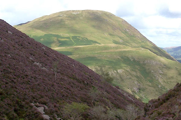 BVH01.jpg From S. (taken 17.8.2011) 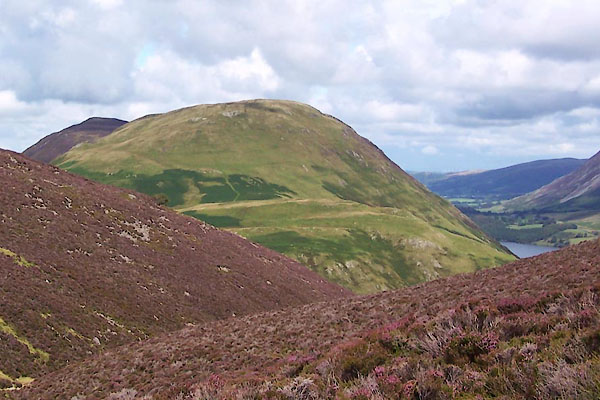 BVH02.jpg From S. (taken 17.8.2011)  BLM51.jpg WNW from Hause Point. (taken 25.12.2005) 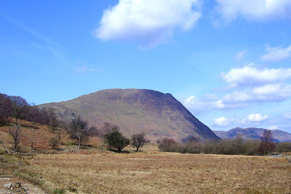 BPA45.jpg (taken 16.4.2008) 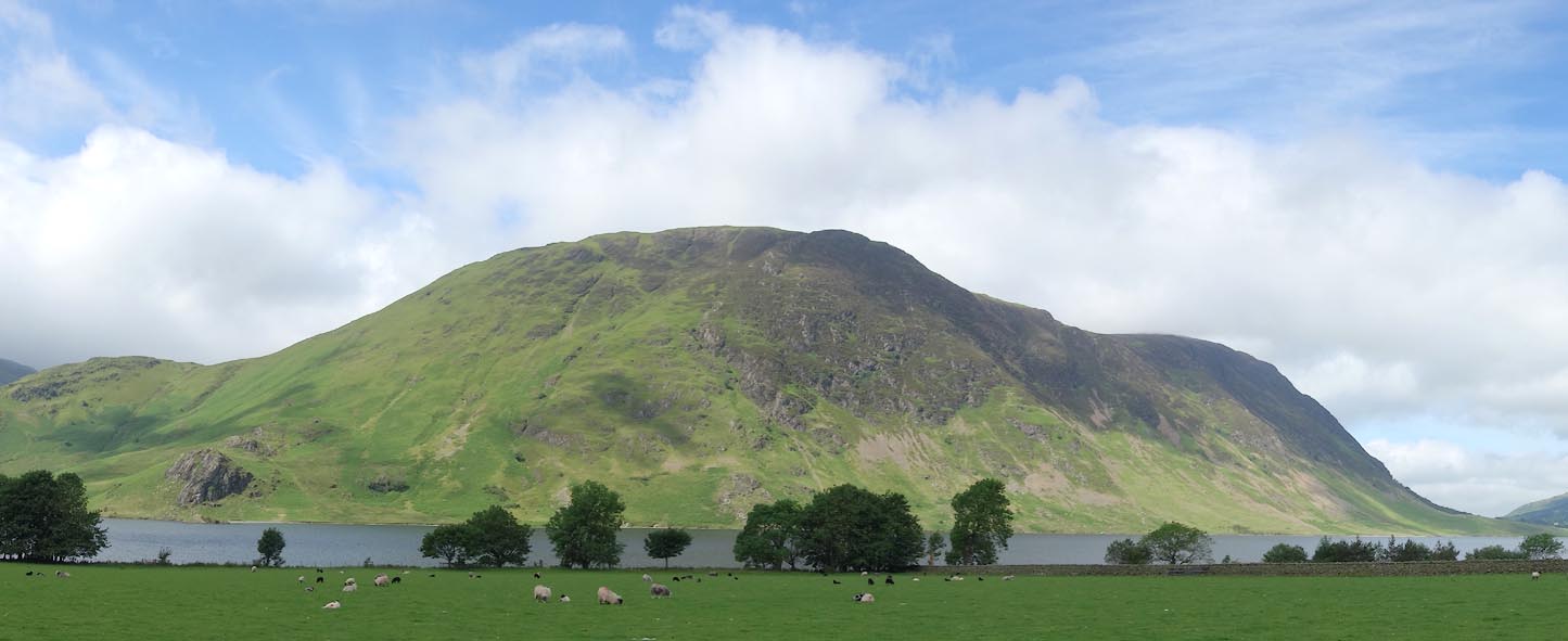 Click to enlarge CAY02.jpg (taken 11.6.2014) |
||
|
|
||
Lakes Guides menu.