 Old Cumbria Gazetteer
 |
 |
|
| Penrith Castle, Penrith | ||
| Penrith Castle | ||
| site name:- | Castle Park | |
| locality:- | Penrith | |
| civil parish:- | Penrith (formerly Cumberland) | |
| county:- | Cumbria | |
| locality type:- | castle | |
| coordinates:- | NY51242993 | |
| 1Km square:- | NY5129 | |
| 10Km square:- | NY52 | |
|
|
||
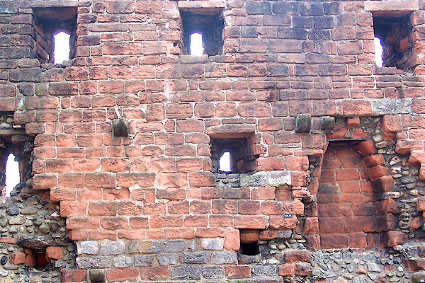
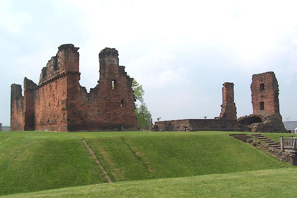 BMC64.jpg (taken 12.5.2006) 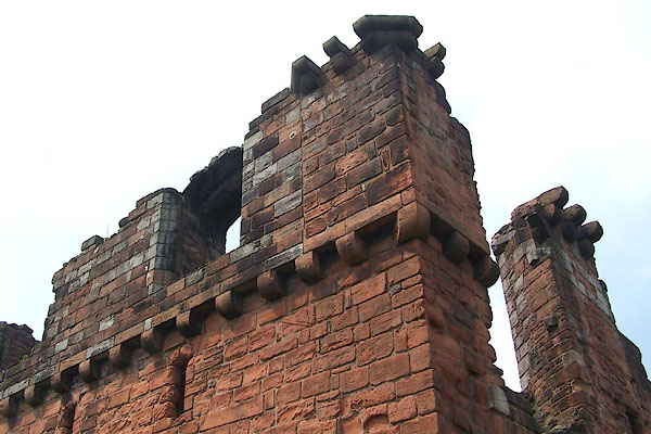 BMC65.jpg (taken 12.5.2006) |
||
|
|
||
| evidence:- | old map:- OS County Series (Cmd 58 4) placename:- Penrith Castle |
|
| source data:- | Maps, County Series maps of Great Britain, scales 6 and 25
inches to 1 mile, published by the Ordnance Survey, Southampton,
Hampshire, from about 1863 to 1948. "Penrith Castle (Ruins of)" |
|
|
|
||
| evidence:- | old map:- Morden 1695 (Cmd) |
|
| source data:- | Map, uncoloured engraving, Cumberland, scale about 4 miles to 1
inch, by Robert Morden, 1695, published by Abel Swale, the
Unicorn, St Paul's Churchyard, Awnsham, and John Churchill, the
Black Swan, Paternoster Row, London, 1695-1715.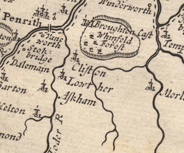 MD12NY52.jpg Circle, with a flag? item:- JandMN : 90 Image © see bottom of page |
|
|
|
||
| evidence:- | descriptive text:- Bowen 1720 (plate 94) |
|
| source data:- | Road book, Britannia Depicta Or Ogilby Improv'd, including road
strip maps with sections in Westmorland and Cumberland, scale
about 2 miles to 1 inch, derived from maps by Ogilby, 1675, also
a county map of Westmorland, scale about 8 miles to 1 inch, and
of Cumberland, scale about 16.5 miles to 1 inch, each with text,
by John Owen, published by Emanuel Bowen, London, 1720;
published 1720-64. "The West Side of this Town [Penrith] is fortified wth. a Royal Castle." |
|
|
|
||
| evidence:- | old print:- Buck 1739 placename:- Penrith Castle item:- Maburg (Mayburgh); Mayburgh, Yanwath etc; roman fort, Eamont Bridge; Arthur's Round Table, Eamont Bridge |
|
| source data:- | Print, uncoloured engraving, The North View of Penrith Castle, in the County of Cumberland,
drawn and engraved by Samuel and Nathaniel Buck, published 1739.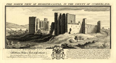 click to enlarge click to enlargeBU0214.jpg printed, top "THE NORTH VIEW OF PENRITH-CASTLE, IN THE COUNTY OF CUMBERLAND." printed, bottom "THIS Castle was formerly one of ye King's; but it does not appear when or by whom it was founded. It was repair'd, as Mr. Camden tells us, in ye Reign of K. Hen. 6th. out of ye Ruins of Maburg, a Roman Fort hard by: But ye late Annotator upon that Author is positive, that it was never repair'd out of ye Ruins of Maburg, and that neither was That ever a Roman Fort, but a Danish Temple. However that be, this Castle, wch. has long been itself in Ruins, continued in ye Crown till K. Will. III. who granted it, with ye Honour of Penrith, to William Bentinck Earl of Portland, Grandfather to his Grace ye present Duke of that Title. / 1. Penrith Saml. &Nathl. Buck delin: et Sculp: Publish'd according to Act of Parliamt. March 26. 1739." item:- Armitt Library : 1959.67.14 Image © see bottom of page |
|
|
|
||
| evidence:- | descriptive text:- Simpson 1746 placename:- Penrith Castle |
|
| source data:- | Atlas, three volumes of maps and descriptive text published as
'The Agreeable Historian, or the Compleat English Traveller
...', by Samuel Simpson, 1746. goto source goto source"..." "The W. Side of this Town [Penrith] was fortify'd with a Castle now in Ruins. ..." goto source"... Penrith Castle, the Seat of the Right Hon. Sackvile Tufton, Earl of Thanet, who married one of the Daughters of the late Marquis of Halifax. ..." |
|
|
|
||
| evidence:- | old map:- Jefferys 1770 (Wmd) |
|
| source data:- | Map, 4 sheets, The County of Westmoreland, scale 1 inch to 1
mile, surveyed 1768, and engraved and published by Thomas
Jefferys, London, 1770. J5NY52NW.jpg castle item:- National Library of Scotland : EME.s.47 Image © National Library of Scotland |
|
|
|
||
| evidence:- | old map:- Donald 1774 (Cmd) |
|
| source data:- | Map, hand coloured engraving, 3x2 sheets, The County of Cumberland, scale about 1
inch to 1 mile, by Thomas Donald, engraved and published by Joseph Hodskinson, 29
Arundel Street, Strand, London, 1774. D4NY52NW.jpg "Castle" large building; a castle item:- Carlisle Library : Map 2 Image © Carlisle Library |
|
|
|
||
| evidence:- | descriptive text:- West 1778 (11th edn 1821) |
|
| source data:- | Guide book, A Guide to the Lakes, by Thomas West, published by
William Pennington, Kendal, Cumbria once Westmorland, and in
London, 1778 to 1821. goto source Page 168:- "..." "... the awful remains of the royal fortress on the crest of the rising ground that commands the town. It is supposed to be an erection of Henry VI. out of the ruins of a more ancient structure called Mayburgh; but this is not very probable, since stones are easier quarried here than they could be got there. But as popular records have generally some fact to rest upon, and some truth in the bottom, so some facings and other principal stones taken from Mayburgh, might give rise to the tradition. There might also have been a stronghold here in the time of the Romans. At present the buildings are ruins in the last stage. One stone arched vault only remains, that from its situation appears to have been the keep, now no longer terrible, since the border service ceased, ..." |
|
|
|
||
| evidence:- | old text:- Gilpin 1786 placename:- Penrith Castle |
|
| source data:- | Book, Observations, Relative Chiefly to Picturesque Beauty, Made
in the Year 1772, on Several Parts of England, Particularly the
Mountains, and Lakes of Cumberland Westmoreland, by Rev William
Gilpin, 1772-74; published 1786-1808. goto source vol.2 p.84 "Before we arrived at Penrith, one of these fortresses, which is known by the name of Penrith-castle, presented us with a very noble ruin; and under the most interesting circumstances. The sun, which, through the length" goto sourcevol.2 p.85 "of a summer-day, had befriended us with all his morning, noon, and evening powers; preparing now, with farewell sweet, to take his leave, gave us yet one more beautiful exhibition." "A grand broken arch presented itself first in deep shadow. Through the aperture appeared a part of the internal structure, thrown into perspective to great advantage; and illuminated by the departing ray. Other fragments of the shattered towers, and battelments were just touched with the splendid tint: but the body of light rested on those parts, which were seen through the shadowed arch." "..." |
|
|
|
||
| evidence:- | old text:- Clarke 1787 placename:- Penrith Castle |
|
| source data:- | Guide book, A Survey of the Lakes of Cumberland, Westmorland,
and Lancashire, written and published by James Clarke, Penrith,
Cumberland, and in London etc, 1787; published 1787-93. goto source Page 10:- "..." "Dr. Burn and some others say, that Penrith Castle was built of the stones which were" goto sourcePage 11:- "taken from Mayburgh; but as neither the stones are of the same kind, nor were the roads in those times practicable for carriages, they must surely be wrong informed." |
|
|
|
||
| evidence:- | old text:- Clarke 1787 |
|
| source data:- | Guide book, A Survey of the Lakes of Cumberland, Westmorland,
and Lancashire, written and published by James Clarke, Penrith,
Cumberland, and in London etc, 1787; published 1787-93. goto source Page 19:- "..." "On the South side of the town [Penrith] stands a castle, on a rising ground, and seems once to have been a place of strength, as it is surrounded with a moat and other defences. The first founder is unknown; but before the year 1237 it must have been a very inconsiderable fortress; for at that time we find, that 200 librates of land were granted to William King of Scots. These were to be set out, according to agreements, in the counties of Cumberland and Northumberland, where no castles were; and in case of deficiency of land so situated, it was to be set out in the neighbouring counties." "Now it appears from the boundary-roll (taken at a perambulation 29. Edward II.) that the forest of Inglewood, together with the honour of Penrith, were the 200 librates before named: it farther appears, that in the year 1432, Richard duke of Gloucester, (afterwards Richard III.) resided here in quality of Sheriff of Cumberland. He repaired the castle, and lived here five years together, in order to collect those northern clans which were of the York party, and to keep in awe those which were of the Lancaster party." "That part of the building which now remains appears to be of a much older date, as the stones as so firmly cemented as to resist the efforts of the workmen who attempted to pull it down; whereas the Duke's repairs, consisting of a tower, porter's-lodge, and some other detached buildings, gave way very readily: besides, the repairs were executed in white stones, whereas the old building is composed of red ones. The most probable supposition is, that before the Duke's coming, it was an old dismantled" goto sourcePage 20:- "building, (perhaps burnt and demolished in some of the inroads of the Scots,) and of course not rated as a castle, and that the Duke made the old port (sic) habitable, and added to it those works of defence which are now taken away. The only remains of the castle are a large square building, and several arched cellars, which were probably the dungeons, or keeps. One thing however is remarkable; an arched, subterraneous road leads all the way from the castle to the kitchen-floor of an house in the town, called Dockwray-Hall, the distance being 307 yards. Such subterraneous roads were not unfrequent in these old fortresses, and were doubtless intended for conveying provisions, and preventing surprises." |
|
|
|
||
| evidence:- | old text:- Clarke 1787 placename:- Penrith Castle |
|
| source data:- | Guide book, A Survey of the Lakes of Cumberland, Westmorland,
and Lancashire, written and published by James Clarke, Penrith,
Cumberland, and in London etc, 1787; published 1787-93. goto source Page 105:- "..." "I do not find any ancient authors mention a castle here [Castlerigg], Speed, who speaks of twenty-five in Cumberland, hath found out every one I ever heard or knew of, except Kirkoswald; how that has escaped him I cannot tell. I shall here put down their names, and, as well as I can, their most ancient owners, and supposed founders." "..." goto sourcePage 106:- "..." "18. PENRITH. Some say Henry VI. others Richard III. I do not believe either. (For reasons, see account of it.)" "..." |
|
|
|
||
| evidence:- | old text:- Camden 1789 |
|
| source data:- | Book, Britannia, or A Chorographical Description of the Flourishing Kingdoms of England,
Scotland, and Ireland, by William Camden, 1586, translated from the 1607 Latin edition
by Richard Gough, published London, 1789. goto source Page 173:- "..." "[Penrith] ... defended on the west by a royal castle, repaired t. Henry VI. with the ruins of the neighbouring Roman fort called Maburg, ..." |
|
|
|
||
| evidence:- | old text:- Camden 1789 (Gough Additions) |
|
| source data:- | Book, Britannia, or A Chorographical Description of the Flourishing Kingdoms of England,
Scotland, and Ireland, by William Camden, 1586, translated from the 1607 Latin edition
by Richard Gough, published London, 1789. goto source Page 188:- "..." ""Pereth, ... where is a strong castle of the king's, ..."" goto sourcePage 189:- "... The castle is a large square building, on high ground to the west, single trenched, and is as old as Henry III. ..." "This town was burnt by the Scots 19 Edward III. and 8 Richard II. Richard III. when duke of Gloucester, lodged in the castle, to check the Scots, and enlarged the works with stones as it is said from Mayboro' before-mentioned." |
|
|
|
||
| evidence:- | descriptive text:- Baker 1802 |
|
| source data:- | Perspective road map with sections in Lancashire, Westmorland,
and Cumberland, by J Baker, London 1802. pp.25-26:- "..." "Penrith ... on another side the ruins of an antient castle occupy the landscape." "Some say this was built in the reign of Henry IId, whilst others attribute it to the time of Henry VI. ..." |
|
|
|
||
| evidence:- | old map:- Baker 1802 |
|
| source data:- | Perspective road maps with sections in Lancashire, Westmorland
and Cumberland, by J Baker, London 1802. Bk03Vg04.jpg item:- private collection : 3 Image © see bottom of page |
|
|
|
||
| evidence:- | old print:- Green 1804 (plate 35) placename:- Penrith Castle |
|
| source data:- | Print, uncoloured aquatint, Penrith Castle, Penrith, Cumberland, by William Green,
Ambleside, Westmorland, 1804.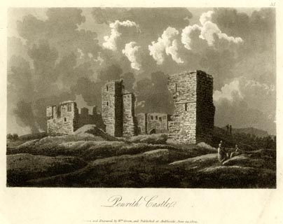 click to enlarge click to enlargeGN1635.jpg Plate 35 from a series. printed at bottom:- "Penrith Castle. / Drawn and Engraved by Wm. Green, and Published at Ambleside, June 24, 1804." printed at top right:- "35" item:- Armitt Library : 2014.183 Image © see bottom of page |
|
|
|
||
| evidence:- | old text:- Capper 1808 |
|
| source data:- | Gazetteer, A Topographical Dictionary of the United Kingdom,
compiled by Benjamin Pitts Capper, published by Richard
Phillips, Bridge Street, Blackfriars, London, 1808; published
1808-29. goto source "[Penrith] ... a long time continued in the possession of the Scots; but it being disputed by the English, it was twice burnt in the reigns of Edward III. and Richard II. when it had a castle erected to check the depredations of the Scots. ..." |
|
|
|
||
| evidence:- | old text:- Gents Mag |
|
| source data:- | Magazine, The Gentleman's Magazine or Monthly Intelligencer or
Historical Chronicle, published by Edward Cave under the
pseudonym Sylvanus Urban, and by other publishers, London,
monthly from 1731 to 1922. goto source Gentleman's Magazine 1819 part 1 p.508 From the Compendium of County History:- "Penrith castle was enlarged and repaired by Richard Duke of Gloucester, afterwards Richard III. who made it his principal residence for five years. ..." |
|
|
|
||
| evidence:- | old print:- Fielding and Walton 1821 (plate 40) placename:- Penrith Castle |
|
| source data:- | Print, coloured aquatint, Penrith Castle, Cumberland, drawn by Theodore H A Fielding,
published by R Ackermann, 101 Strand, London, 1821.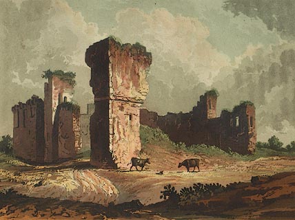 click to enlarge click to enlargeFW0140.jpg Tipped in opposite p.259 in A Picturesque Tour of the English Lakes. item:- Dove Cottage : 1993.R566.40 Image © see bottom of page |
|
|
|
||
| evidence:- | descriptive text:- Ford 1839 (3rd edn 1843) |
|
| source data:- | Guide book, A Description of Scenery in the Lake District, by
Rev William Ford, published by Charles Thurnam, Carlisle, by W
Edwards, 12 Ave Maria Lane, Charles Tilt, Fleet Street, William
Smith, 113 Fleet Street, London, by Currie and Bowman,
Newcastle, by Bancks and Co, Manchester, by Oliver and Boyd,
Edinburgh, and by Sinclair, Dumfries, 1839. goto source Page 132:- "[The] ruins of the Castle are on the west side of the town: it is thought or have been built about the end of the fourteenth century, during the reign of Edward IV, and was once the residence of Richard of Glo'ster. It was dismantled in the civil wars. From the remaining parts of the walls, the Castle seems to have been a very strong and spacious fortress, with the usual accompaniments of dungeons. ..." |
|
|
|
||
| evidence:- | old print:- Philip/Wilson 1890s |
|
| source data:- | Print, engraving, Penrith Castle, published by George Philip and
Son, London, Philip, Son and Nephew, Liverpool, Lancashire, and
Titus Wilson, Kendal, Westmorland, about 1895.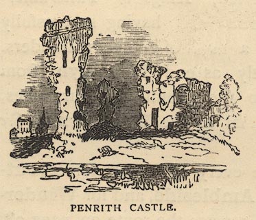 click to enlarge click to enlargePW1E35.jpg "PENRITH CASTLE." item:- JandMN : 58.36 Image © see bottom of page |
|
|
|
||
| evidence:- | old print:- Taylor 1892 placename:- Penrith Castle |
|
| source data:- | Print, halftone photograph, Penrith Castle, Penrith, Cumberland, published for the
Cumberland and Westmorland Antiquarian and Archaeological Society, by Titus Wilson,
Kendal, Westmorland, and by Charles Thurnam and Sons, Carlisle, Cumberland, 1892.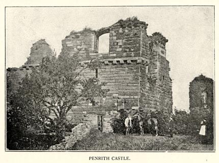 click to enlarge click to enlargeTY5053.jpg Tipped in opposite p.244 of The Old Manorial Halls of Cumberland and Westmorland, by Michael Waistell Taylor. item:- Armitt Library : A785.53 Image © see bottom of page |
|
|
|
||
| evidence:- | old print:- Taylor 1892 placename:- Penrith Castle |
|
| source data:- | Print, plan of Penrith Castle, Penrith, Cumberland, published for the Cumberland and
Westmorland Antiquarian and Archaeological Society, by Titus Wilson, Kendal, Westmorland,
and by Charles Thurnam and Sons, Carlisle, Cumberland, 1892.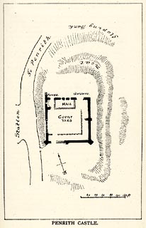 click to enlarge click to enlargeTY5054.jpg Tipped in opposite p.246 of The Old Manorial Halls of Cumberland and Westmorland, by Michael Waistell Taylor. item:- Armitt Library : A785.54 Image © see bottom of page |
|
|
|
||
| evidence:- | old photograph:- Ullswater Steamers 1900s (edn 1903) placename:- Penrith Castle |
|
| source data:- | Photograph, bw halftone, Penrith Castle, Penrith, Cumberland, published in a guide
book by the Ullswater Steam Navigation Co, Penrith, Cumberland, 1903.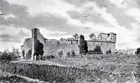 click to enlarge click to enlargeUN104.jpg item:- JandMN : 1023.4 Image © see bottom of page |
|
|
|
||
| evidence:- | old print:- Bradley 1901 placename:- Penrith Castle |
|
| source data:- | Print, uncoloured lithograph, Penrith Castle, Penrith, Cumberland, by Joseph Pennell,
published by Macmillan and Co, London, 1901. click to enlarge click to enlargeBRL102.jpg On page 1 of Highways and Byways in the Lake District, by A G Bradley. printed at bottom:- "Penrith Castle." item:- JandMN : 464.2 Image © see bottom of page |
|
|
|
||
| evidence:- | old text:- Harper 1907 |
|
| source data:- | Guidebook, The Manchester and Glasgow Road, by Charles G Harper,
published by Chapman and Hall Ltd, London, 1907. HP01p130.txt Page 130:- "..." "The next year [1346 after an incursion], the remaining inhabitants of Penrith, graciously permitted by the King to protect themselves," HP01p131.txt Page 131:- "build a communal castle. and each townsman so far as was possible to him, rebuilt his own dwelling-house in a strong and defensible way. Hence the grim, thick-walled houses that even now line many of the narrow streets." "That the Castle was at least once rebuilt seems certain. One of these rebuildings was that by Richard, Duke of Gloucester, who, before he became that inimitable character of history, Richard the Third, was Governor of these marches, and resided here in every circumstance of magnificence. Now the place is a ruin, a condition it owes to the Penrith people themselves, who early in the time of Queen Elizabeth considered they had a more pressing need for a prison than a fortress, and accordingly with thirty loads of stone, erected a very secure, if not very comfortable, gaol. ..." "There is thus nothing pictorial in the bare, roofless red walls of the Castle. It has little, or no story, and stands in the unromantic neighbourhood of the railway station, in a lofty situation on a hilltop above the town." |
|
|
|
||
| evidence:- | text:- Curwen 1913 item:- licence to crenellate; Bishop's Tower |
|
| source data:- | Book, The Castles and Fortified Towers of Cumberland,
Westmorland, and Lancashire North of the Sands, by John F
Curwen, published for the Cumberland and Westmorland Antiquarian
and Archaeological Society by Titus Wilson, Kendal, Westmorland,
1913. Licence to crenellate granted by Edward III "Willielmus Stirkeland, clericus, ... cameram suam in villa de Penereth in Marchia Scotiae ..." The Bishop's Tower |
|
|
|
||
| evidence:- | old text:- Burrow 1920s placename:- |
|
| source data:- | Road book, strip maps with parts in Westmorland, Cumberland etc,
irregular scales about 1.5 miles to 1 inch, by E J Burrow and
Co, Cheltenham, Gloucestershire, 1920s. "...the merest fragment of its castle lingering near the railway station. ..." |
|
|
|
||
| evidence:- | database:- Listed Buildings 2010 placename:- Penrith Castle |
|
| source data:- | courtesy of English Heritage "PENRITH CASTLE / / ULLSWATER ROAD / PENRITH / EDEN / CUMBRIA / I / 72957 / NY5126429939" |
|
| source data:- | courtesy of English Heritage "Red sandstone ruins. Licence to crenellate 1397. Square plan with gateway on north-east. Circular well in courtyard. Additions of circa 1470. South wall and east tower remain to a considerable height, also tunnel vaults, Perpendicular windows, and pointed arched fireplace flues. Gatehouse ruins on north-west. AM." |
|
|
|
||
| evidence:- | old print:- Robertson 1911 |
|
| source data:- | Print, lithograph? Skiddaw and Blancathra, Seen from the Side of Penrith Beacon, from
a watercolour by Arthur Tucker, published by Chatto and Windus, London, 1911. click to enlarge click to enlargeRSN102.jpg Tipped in opposite p.4 of Wordsworthshire by Eric Robertson. printed at bottom:- "SKIDDAW AND BLENCATHRA, SEEN FROM THE SIDE OF PENRITH BEACON / (In foreground and middle distance, Scumshaw Farm, Church and Castle of Penrith)" item:- JandMN : 197.2 Image © see bottom of page |
|
|
|
||
| evidence:- | old print:- Sylvan 1847 placename:- Penrith Castle |
|
| source data:- | Print, engraving, Ruins of Penrith Castle, Cumberland, published by John Johnstone,
Paternoster Row, London, et al, 1847.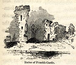 click to enlarge click to enlargeSYL159.jpg On p.227 of Sylvan's Pictorial Guide to the English Lakes. printed at bottom:- "RUINS OF PENRITH CASTLE." item:- Armitt Library : A1201.59 Image © see bottom of page |
|
|
|
||
| evidence:- | old print:- placename:- Penrith Castle |
|
| source data:- | Print, uncoloured aquatint, Penrith Castle, Cumberland, published by J Hassell, London,
1806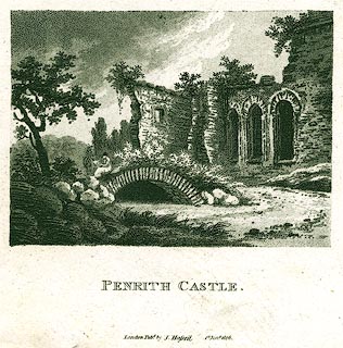 click to enlarge click to enlargePR0291.jpg printed at bottom:- "PENRITH CASTLE. / London. Pubd. nu J. Hassell 1st. Jan. 1806." item:- Dove Cottage : 2008.107.291 Image © see bottom of page |
|
|
|
||
| evidence:- | old print:- placename:- Penrith Castle |
|
| source data:- | Print, uncoloured engraving, Penrith Castle, Cumberland, engraved by I Pye, published
by Samuel Hooper, 1784.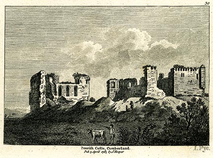 click to enlarge click to enlargePR0233.jpg printed at top right:- "30" printed at bottom right, centre:- "I. Pye. / Penrith Castle, Cumberland. / Pub. 3 April 1784 by S. Hooper" item:- Dove Cottage : 2008.107.233 Image © see bottom of page |
|
|
|
||
| evidence:- | old print with text:- Lowther 1780s-90s item:- roman fort |
|
| source data:- | Print, engraving, Penrith Castle, Penrith, Cumberland now Cumbria, by I Pye, 1775;
with descriptive text:-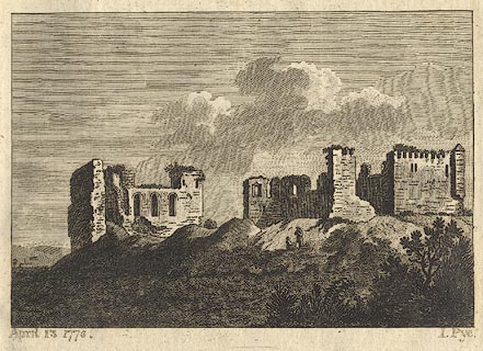 click to enlarge click to enlargeBMZ21.jpg "PENRITH CASTLE, CUMBERLAND." "THIS castle stands near the west end of the town: both its builder and the time of its construction are unknown. Leland, who mentions it in his itinerary, calls it 'A strong castel of the kinges;' an appelation it does not from its remains appear to have deserved." "CAMDEN also speaks of it, but neither mentions the date of its erection, nor its founder: he, indeed, says, it was repaired in Henry the Sixth's time, out of the ruins of Mayburg. This is by his last editor justly deemed a mistake, and contradicted in a marginal note." "IT is built of a course red sandstone, and was nearly square, each side measuring about 25 feet. All but a small fragment of the north wall is tumbled down. There seems to have been a small bastion-like projection on the south-west angle, but by much too trifling to serve for a defence. The south-east and north-west cannot be discovered, those angles being entirely demolished. In the middle of each face was a small projection like a buttress or turret, and round the top of the walls run brackets, such as usually support machicolations; but these seem to have been intended rather for shew than use. Neither the height nor thick[ness]" "[thick]ness of the walls are extraordinary; the former nowhere exceeding thirty, nor the latter five feet." "THIS building seems to owe its present ruinous state to more violent causes than the slow depredations of time and weather: yet history does not mention it as the scene of any great military achievement; neither was its form destitute of flanks, by any means calculated to sustain a seige. Perhaps the value of its materials may have conduced to its destruction; for such a propensity have our farmers to destroy an ancient monument, that they will bestow more labour to disjoint a few stones to mend their buildings, than would earn them enough to purchase three times the quantity." "THIS castle, it is said, continued in the crown till the reign of King William the Third, when that prince granted it, together with the honour of Penrith, to William Bentinck, earl of Portland, ancestor to the present duke of Portland." "IN a pleasing description of this part of the country, entitled 'An Excursion to the Lakes,' there is the following agreeable portrait of this castle:" "'WE viewed the ruins of Penrith Castle:- it is said to have arose on the foundations of a Roman fortress, the traces of which are not now to be discovered. The buildings form a square, and are situate on a rising ground surrounded with a ditch.- The scite towards the town is much more elevated than on any of the other quarters. This front consists of the remains of an angular tower to the east, which now stands separately from the rest by the falling of the walls: the centre, which projects a little from the plane of the front, is hastening to decay, presenting to the eye broken chambers, passages, and stairs.- This part of the building is still connected with the western angular tower, an open hanging gallery forming the communication.- Below this gallery a large opening is made by the falling of the building, forming a rude arch, through which, and the broken walls to the east, the interior parts of the ruin are perceived in a picturesque manner.- Nothing remains within but part of a stone arch vault, which, by its similitude to places of the like nature which we had formerly seen, we conceived to have been the prison.'" "This view, which represents the north-west aspect, was drawn anno 1774." item:- Dove Cottage : Lowther.74 Image © see bottom of page |
|
|
|
||
| evidence:- | old print:- Lowther 1780s-90s |
|
| source data:- | Print, engraving, plans of Penrith Castle, Penrith, and Carlisle Castle, Carlisle,
Cumberland now Cumbria, late 18th century.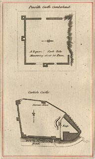 click to enlarge click to enlargeBMZ23.jpg item:- Dove Cottage : Lowther.76 Image © see bottom of page |
|
|
|
||
| evidence:- | old print:- Lowther 1780s-90s |
|
| source data:- | Print, engraving, North View of Penrith Castle, Penrith, Cumberland now Cumbria, late
18th century.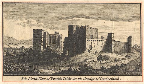 click to enlarge click to enlargeBMZ22.jpg item:- Dove Cottage : Lowther.75 Image © see bottom of page |
|
|
|
||
| evidence:- | old print:- placename:- Penrith Castle |
|
| source data:- | Print, uncoloured engraving, Penrith Castle, Cumberland, engraved by I Pye, published
by Samuel Hooper, 1775.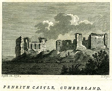 click to enlarge click to enlargePR0215.jpg printed at bottom left, right, centre:- "April 13, 1775. / I. Pye. / PENRITH CASTLE, CUMBERLAND. / ..." item:- Dove Cottage : 2008.107.215 Image © see bottom of page |
|
|
|
||
| evidence:- | old print:- placename:- Penrith Castle |
|
| source data:- | Print, plan, uncoloured engraving, Penrith Castle Cumberland, late 18th century?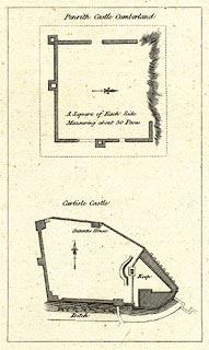 click to enlarge click to enlargePR0207.jpg printed at upper centre:- "Penrith Castle Cumberland" item:- Dove Cottage : 2008.107.207 Image © see bottom of page |
|
|
|
||
| evidence:- | old print:- placename:- Penrith Castle |
|
| source data:- | Print, uncoloured engraving, The North View of Penrith Castle, Cumberland, about 1769.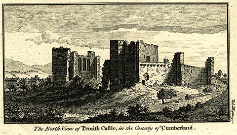 click to enlarge click to enlargePR0188.jpg Included in vol.3 p.44 of a set of castle pictures? printed at bottom:- "The North View of Penrith Castle, in the County of Cumberland." printed at top left of page:- "Vol.III pa.44." item:- Dove Cottage : 2008.107.188 Image © see bottom of page |
|
|
|
||
 BMC66.jpg (taken 12.5.2006) 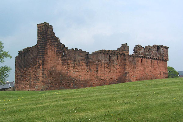 BMC63.jpg (taken 12.5.2006) |
||
|
|
||
| hearsay:- |
Built to defend Penrith against raiders from the north, 14th century; the licence
to crenellate was granted 1397. |
|
|
|
||
| notes:- |
Built to defend Penrith against incursions from Scotland.A tower was built by Bishop
Strickland. The courtyard was laid out at the end of the 14th century. |
|
|
|
||
| notes:- |
tower, hall, curtain walls, gateway, moat, all in ruins |
|
| Perriam, D R & Robinson, J: 1998: Medieval Fortified Buildings of Cumbria: CWAAS::
ISBN 1 873124 23 6; plan &illustrations |
||
|
|
||
| person:- | : English Heritage |
|
|
|
||
Lakes Guides menu.