Old Cumbria Gazetteer
 |
 |
|
||
| Poltross Burn | ||||
| runs into:- |  Irthing, River Irthing, River |
|||
|
|
||||
| civil parish:- | Upper Denton (formerly Cumberland) | |||
| county:- | Cumbria | |||
| locality type:- | river | |||
| locality type:- | boundary | |||
| locality type:- | county boundary | |||
| 1Km square:- | NY6366 (etc) | |||
| 10Km square:- | NY66 | |||
| county:- | Northumberland | |||
| current boundary | ||||
| locality:- | Cumbria boundary | |||
| old boundary | ||||
| locality:- | Cumberland boundary | |||
|
|
||||
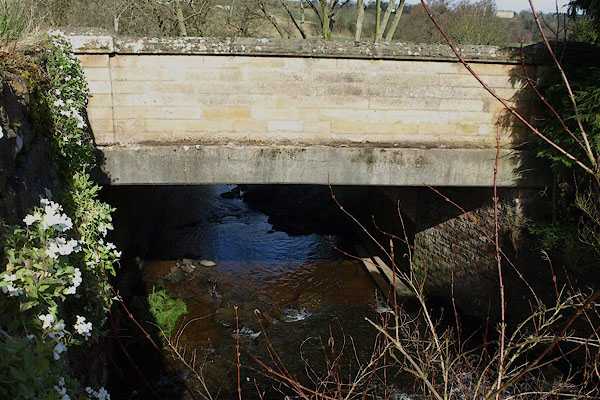
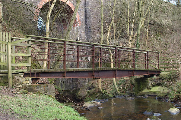
 BOV45.jpg At the footbridge, Gilsland. (taken 21.3.2008) 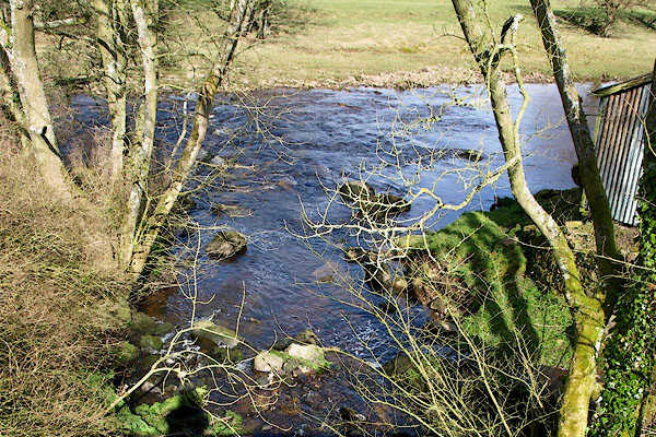 BOV53.jpg Running into the Irthing, Gilsland. (taken 21.3.2008) |
||||
|
|
||||
| evidence:- | old map:- OS County Series (Cmd 12 16) placename:- Poltross Burn |
|||
| source data:- | Maps, County Series maps of Great Britain, scales 6 and 25
inches to 1 mile, published by the Ordnance Survey, Southampton,
Hampshire, from about 1863 to 1948. |
|||
|
|
||||
| evidence:- | old map:- Saxton 1579 placename:- Poltrose Flu. |
|||
| source data:- | Map, hand coloured engraving, Westmorlandiae et Cumberlandiae Comitatus ie Westmorland
and Cumberland, scale about 5 miles to 1 inch, by Christopher Saxton, London, engraved
by Augustinus Ryther, 1576, published 1579-1645.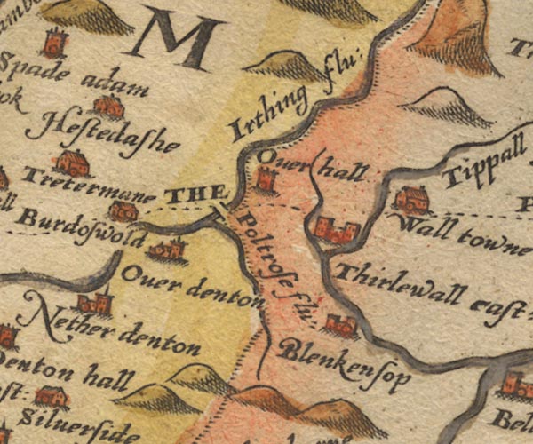 Sax9NY66.jpg "Poltrose flu:" County boundary. item:- private collection : 2 Image © see bottom of page |
|||
|
|
||||
| evidence:- | old map:- Speed 1611 (Cmd) placename:- Poltrose fl. |
|||
| source data:- | Map, hand coloured engraving, Cumberland and the Ancient Citie
Carlile Described, scale about 4 miles to 1 inch, by John Speed,
1610, published by J Sudbury and George Humble, Popes Head
Alley, London, 1611-12.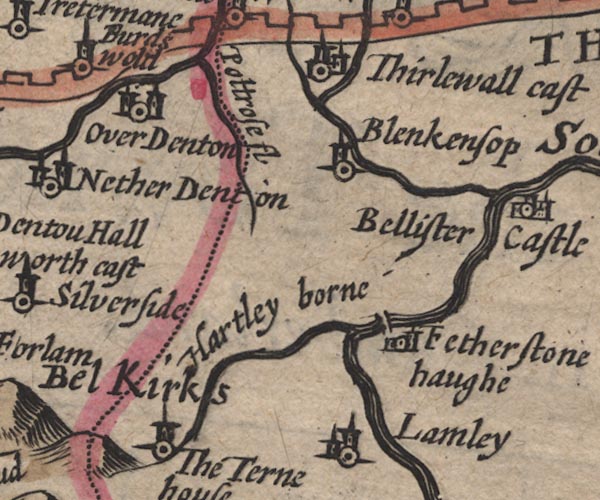 SP11NY66.jpg "Poltrose fl" wiggly line, runs into the Irthing; county boundary item:- private collection : 16 Image © see bottom of page |
|||
|
|
||||
| evidence:- | poem:- Drayton 1612/1622 text placename:- Pultrosse |
|||
| source data:- | Poem, Poly Olbion, by Michael Drayton, published by published by
John Marriott, John Grismand and Thomas Dewe, and others?
London, part 1 1612, part 2 1622. goto source page 167:- "... Pultrosse is her Page, ..." |
|||
|
|
||||
| evidence:- | old map:- Drayton 1612/1622 placename:- Poltrose Fl. |
|||
| source data:- | Map, hand coloured engraving, Cumberlande and Westmorlande, by
Michael Drayton, probably engraved by William Hole, scale about
4 or 5 miles to 1 inch, published by John Mariott, John
Grismand, and Thomas Dewe, London, 1622.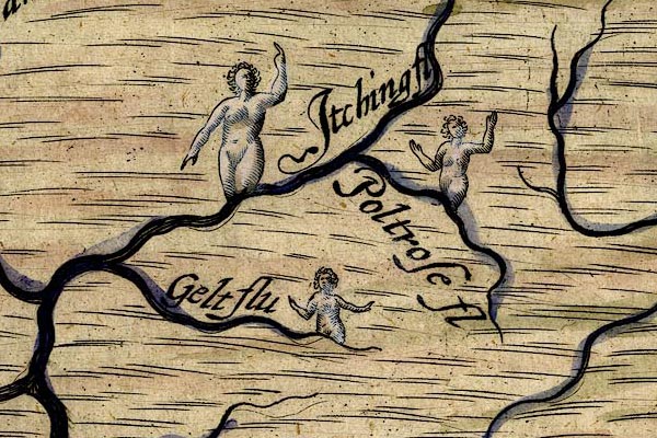 DRY503.jpg "Poltrose fl" River, naiad. item:- JandMN : 168 Image © see bottom of page |
|||
|
|
||||
| evidence:- | old map:- Jansson 1646 |
|||
| source data:- | Map, hand coloured engraving, Cumbria and Westmoria, ie
Cumberland and Westmorland, scale about 3.5 miles to 1 inch, by
John Jansson, Amsterdam, Netherlands, 1646.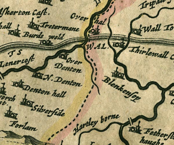 JAN3NY66.jpg Single wiggly line; county boundary. item:- JandMN : 88 Image © see bottom of page |
|||
|
|
||||
| evidence:- | old map:- Ogilby 1675 (plate 86) placename:- Poltrose Fluvius |
|||
| source data:- | Road strip map, uncoloured engraving, the Road from Tinmouth ...
to Carlisle, scale about 1 inch to 1 mile, by John Ogilby,
London, 1675.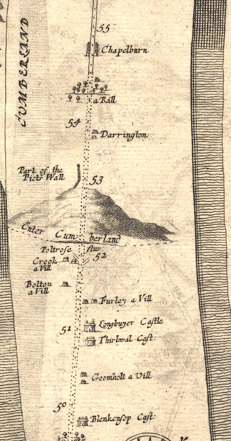 OG86m050.jpg In mile 52, Northumberland, Cumberland. "Poltrose fluv: / Enter Cumberland" river drawn across the road, and county boundary. item:- JandMN : 73 Image © see bottom of page |
|||
|
|
||||
| evidence:- | old map:- Sanson 1679 |
|||
| source data:- | Map, hand coloured engraving, Ancien Royaume de Northumberland
aujourdhuy Provinces de Nort, ie the Ancient Kingdom of
Northumberland or the Northern Provinces, scale about 9.5 miles
to 1 inch, by Nicholas Sanson, Paris, France, 1679. click to enlarge click to enlargeSAN2Cm.jpg tapering wiggly line; river, county boundary with Northumberland item:- Dove Cottage : 2007.38.15 Image © see bottom of page |
|||
|
|
||||
| evidence:- | old map:- Morden 1695 (Cmd) placename:- Poltrose River |
|||
| source data:- | Map, uncoloured engraving, Cumberland, scale about 4 miles to 1
inch, by Robert Morden, 1695, published by Abel Swale, the
Unicorn, St Paul's Churchyard, Awnsham, and John Churchill, the
Black Swan, Paternoster Row, London, 1695-1715.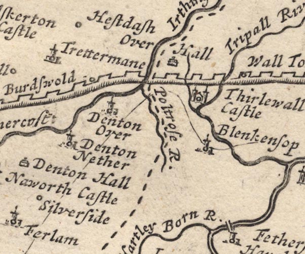 MD12NY66.jpg "Poltrose R." With the county boundary drawn alongside. item:- JandMN : 90 Image © see bottom of page |
|||
|
|
||||
| evidence:- | old map:- Bowen 1720 (plate 232) placename:- Poltrose Flu. |
|||
| source data:- | Road strip map, road map, pl.232, part of The Road from Tinmouth
to Carlisle, scale about 2 miles to 1 inch, with sections in
Northumberland and Cumberland, published by Emanuel Bowen, St
Katherines, London, 1720.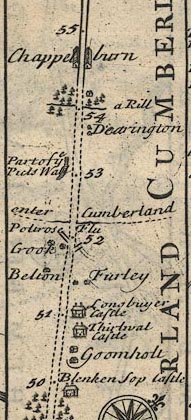 B232m50.jpg "enter Cumberland / Poltrose Flu" Narrow river, county boundary; mile 52+. item:- JandMN : 65.232 Image © see bottom of page |
|||
|
|
||||
| evidence:- | old map:- Bowen and Kitchin 1760 |
|||
| source data:- | Map, hand coloured engraving, A New Map of the Counties of
Cumberland and Westmoreland Divided into their Respective Wards,
scale about 4 miles to 1 inch, by Emanuel Bowen and Thomas
Kitchin et al, published by T Bowles, Robert Sayer, and John
Bowles, London, 1760.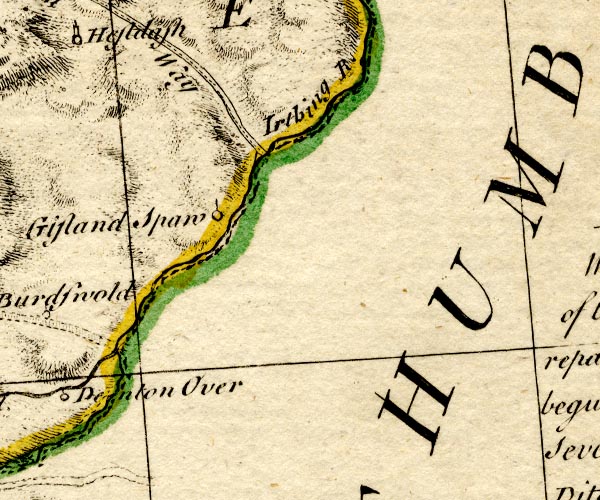 BO18NY76.jpg wiggly line, county boundary Cumberland Northumberland, into the Irthing item:- Armitt Library : 2008.14.10 Image © see bottom of page |
|||
|
|
||||
| evidence:- | old map:- Donald 1774 (Cmd) |
|||
| source data:- | Map, hand coloured engraving, 3x2 sheets, The County of Cumberland, scale about 1
inch to 1 mile, by Thomas Donald, engraved and published by Joseph Hodskinson, 29
Arundel Street, Strand, London, 1774. D4NY66NW.jpg 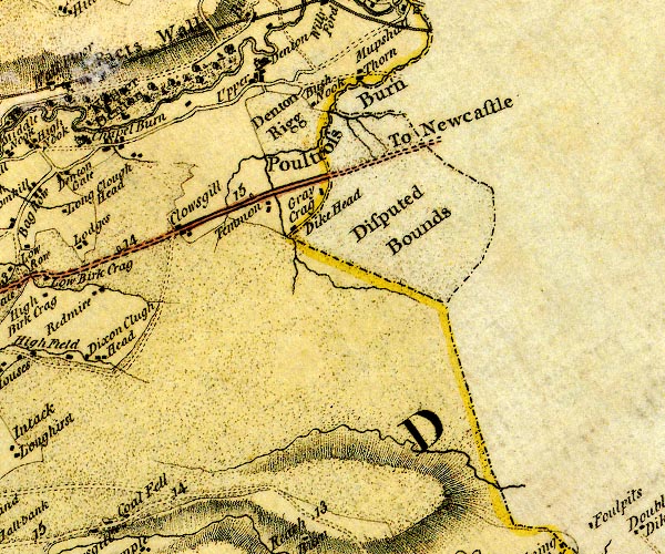 D4NY66SW.jpg "Poultross Burn" single or double wiggly line; a river into the Irthing, and county boundary item:- Carlisle Library : Map 2 Images © Carlisle Library |
|||
|
|
||||
| evidence:- | old text:- Camden 1789 (Gough Additions) placename:- Polt Rosse |
|||
| source data:- | Book, Britannia, or A Chorographical Description of the Flourishing Kingdoms of England,
Scotland, and Ireland, by William Camden, 1586, translated from the 1607 Latin edition
by Richard Gough, published London, 1789. goto source Page 179:- "..." "... a lytle water or mere called Polt Rosse, the which devideth the county of Northumberland on the east side from Cumbreland. ..." |
|||
|
|
||||
| places:- |
|
|||
|
||||
|
||||
|
||||
|
||||
Lakes Guides menu.