Old Cumbria Gazetteer
 |
 |
|
||
| included in:- |
 road, Carlisle to Tynemouth road, Carlisle to Tynemouth |
|||
| road, Brampton to Haltwhistle | ||||
| Brampton to Haltwhistle | ||||
| Haltwhistle to Brampton | ||||
| A69 | ||||
| civil parish:- | Brampton (formerly Cumberland) | |||
| civil parish:- | Nether Denton (formerly Cumberland) | |||
| civil parish:- | Upper Denton (formerly Cumberland) | |||
| county:- | Cumbria | |||
| locality type:- | road route | |||
| 10Km square:- | NY56 | |||
| 10Km square:- | NY66 | |||
| locality:- | Haltwhistle | |||
| county:- | Northumberland | |||
| 10Km square:- | NY66 | |||
| 10Km square:- | NY76 | |||
|
|
||||
| evidence:- | old map:- Ogilby 1675 |
|||
| source data:- | Road strip map, uncoloured engraving, the Road from Tinmouth ...
to Carlisle, scale about 1 inch to 1 mile, by John Ogilby,
London, 1675.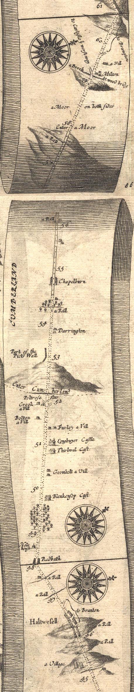 OG86HtoB.jpg item:- JandMN : 73 Image © see bottom of page |
|||
|
|
||||
| evidence:- | old map:- Morden 1695 (Cmd) |
|||
| source data:- | Map, uncoloured engraving, Cumberland, scale about 4 miles to 1
inch, by Robert Morden, 1695, published by Abel Swale, the
Unicorn, St Paul's Churchyard, Awnsham, and John Churchill, the
Black Swan, Paternoster Row, London, 1695-1715. MD12NY55.jpg 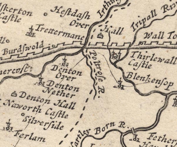 MD12NY66.jpg Single line. item:- JandMN : 90 Image © see bottom of page |
|||
|
|
||||
| evidence:- | old map:- Bowen 1720 (plate 232) |
|||
| source data:- | Road strip map, road map, pl.232, part of The Road from Tinmouth
to Carlisle, scale about 2 miles to 1 inch, with sections in
Northumberland and Cumberland, published by Emanuel Bowen, St
Katherines, London, 1720.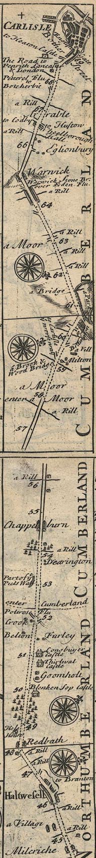 B232HtoC.jpg item:- JandMN : 65.232 Image © see bottom of page |
|||
|
|
||||
| evidence:- | old map:- Bowen and Kitchin 1760 |
|||
| source data:- | Map, hand coloured engraving, A New Map of the Counties of
Cumberland and Westmoreland Divided into their Respective Wards,
scale about 4 miles to 1 inch, by Emanuel Bowen and Thomas
Kitchin et al, published by T Bowles, Robert Sayer, and John
Bowles, London, 1760. BO18NY55.jpg double line, dotted  BO18NY65.jpg double line, dotted, across county boundary Cumberland Northumberland item:- Armitt Library : 2008.14.10 Image © see bottom of page |
|||
|
|
||||
| evidence:- | old map:- Kitchin 1767 (plate 97) |
|||
| source data:- | Road strip map, uncoloured engraving, The Road from Tinmouth to
Carlisle, in Kitchin's Post Chaise Companion, by Thomas Kitchin,
published by Robert Sayer, 53 Fleet Street, John Bowles,
Cornhill, and Carington Bowles, St Paul's Church Yard, London,
1767.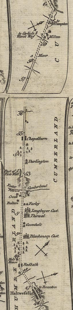 K097HtoB.jpg item:- Hampshire Museums : FA1999.138.97 Image © see bottom of page |
|||
|
|
||||
| evidence:- | old map:- Donald 1774 (Cmd) |
|||
| source data:- | Map, hand coloured engraving, 3x2 sheets, The County of Cumberland, scale about 1
inch to 1 mile, by Thomas Donald, engraved and published by Joseph Hodskinson, 29
Arundel Street, Strand, London, 1774. double line, solid or dotted, with a dot or milestone and number at 1 mile intervals, tinted red; turnpike road  D4NY56SW.jpg  D4NY56SE.jpg  D4NY66SW.jpg into Northumberland "To Newcastle" item:- Carlisle Library : Map 2 Images © Carlisle Library |
|||
|
|
||||
| evidence:- | road map:- Cary 1790 (Cmd/edn 1789) |
|||
| source data:- | Road map, hand coloured engraving, Cumberland, scale about 15
miles to 1 inch, by John Cary, 181 Strand, London, 1790, edn
1789.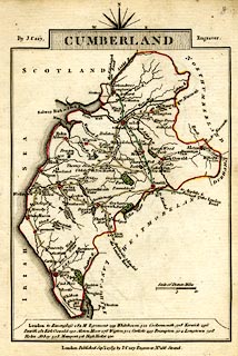 click to enlarge click to enlargeCY47.jpg "to Newcastle" double line, with road distances from Carlisle and from Newcastle item:- JandMN : 419 Image © see bottom of page |
|||
|
|
||||
| evidence:- | road map:- Cary 1790 (Nhd/edn 1806) |
|||
| source data:- | Road map, hand coloured engraving, Northumberland, scale about
17.5 miles to 1 inch, by John Cary, 181 Strand, London, 1790,
edn 1806.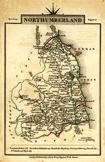 click to enlarge click to enlargeCY45.jpg "from Carlisle" double line, with road distances from Newcastle item:- JandMN : 417 Image © see bottom of page |
|||
|
|
||||
| evidence:- | road book:- Cary 1798 (2nd edn 1802) |
|||
| source data:- | Road book, itineraries, Cary's New Itinerary, by John Cary, 181
Strand, London, 2nd edn 1802. goto source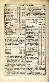 click to enlarge click to enlargeC38699.jpg page 699-700 "NEWCASTLE UPON TYNE to Carlisle, by Hexham (The usual Carriage Road.)" part of "NEWCASTLE UPON TYNE to Carlisle. (The Military Road.)" joins the carriage road at Glenwhelt, before entering Cumberland. item:- JandMN : 228.2 Image © see bottom of page |
|||
|
|
||||
| evidence:- | old map:- Cooke 1802 |
|||
| source data:- | Map, Cumberland, scale about 15.5 miles to 1 inch, by George
Cooke, 1802, bound in Gray's New Book of Roads, 1824, published
by Sherwood, Jones and Co, Paternoster Road, London, 1824. click to enlarge click to enlargeGRA1Cd.jpg "to Newcastle" double line, light dark dotted; unfenced road item:- Hampshire Museums : FA2000.62.2 Image © see bottom of page |
|||
|
|
||||
| evidence:- | old map:- Cooper 1808 |
|||
| source data:- | Map, uncoloured engraving, Cumberland, scale about 10.5 miles to
1 inch, drawn and engraved by Cooper, published by R Phillips,
Bridge Street, Blackfriars, London, 1808. click to enlarge click to enlargeCOP3.jpg double line; road item:- JandMN : 86 Image © see bottom of page |
|||
|
|
||||
| evidence:- | old map:- Wallis 1810 (Cmd) |
|||
| source data:- | Road map, hand coloured engraving, Cumberland, scale about 16
miles to 1 inch, by James Wallis, 77 Berwick Stree, Soho,
London, 1810. click to enlarge click to enlargeWL13.jpg "to Newcastle" double line, light bold; 'Turnpike Road' item:- Dove Cottage : 2009.81.10 Image © see bottom of page |
|||
|
|
||||
| evidence:- | old map:- Hall 1820 (Cmd) |
|||
| source data:- | Map, hand coloured engraving, Cumberland, scale about 21 miles
to 1 inch, engraved by Sidney Hall, published by S Leigh, 18
Strand, London, 1820-31. click to enlarge click to enlargeHA14.jpg "To Haltwhistle" double line, solid; main road; ..., Clowsgill, Brampton, Carlisle; northerly route? item:- JandMN : 91 Image © see bottom of page |
|||
|
|
||||
| evidence:- | old map:- Ford 1839 map |
|||
| source data:- | Map, uncoloured engraving, Map of the Lake District of
Cumberland, Westmoreland and Lancashire, scale about 3.5 miles
to 1 inch, published by Charles Thurnam, Carlisle, and by R
Groombridge, 5 Paternoster Row, London, 3rd edn 1843. FD02NY56.jpg 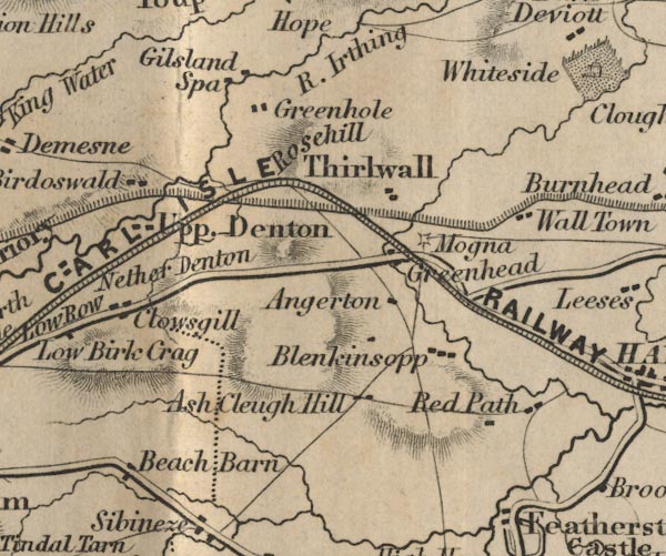 FD02NY66.jpg 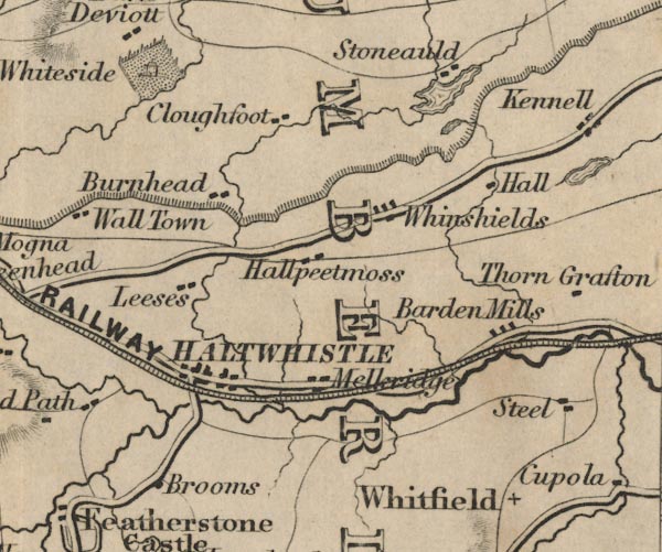 FD02NY76.jpg item:- JandMN : 100.1 Image © see bottom of page |
|||
|
|
||||
| evidence:- | gradient diagram:- Gall and Inglis 1890s-1900s (Roads) |
|||
| source data:- | Contour Road Book of England, Northern Division, by Harry R G Inglis, published by
Gall and Inglis, 25 Paternoster Square, London and Edinburgh, 1898.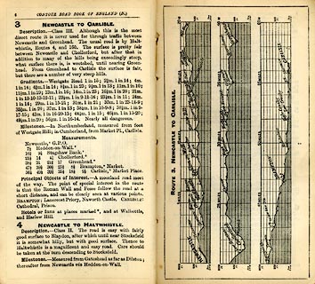 click to enlarge click to enlargeIG5003.jpg Itinerary, with gradient diagram, route 3, Newcastle to Carlisle, Northumberland and Cumberland, 1898. item:- JandMN : 763.2 Image © see bottom of page |
|||
|
|
||||
| evidence:- | gradient diagram:- Gall and Inglis 1890s-1900s (Roads) |
|||
| source data:- | Contour Road Book of England, Northern Division, by Harry R G Inglis, published by
Gall and Inglis, 25 Paternoster Square, London and Edinburgh, 1898.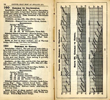 click to enlarge click to enlargeIG5160.jpg Itinerary, with gradient diagram, route 160, Carlisle to Haltwhistle, and route 161, Carlisle to Kendal, Westmorland, Cumberland and Northumberland, 1898. item:- JandMN : 763.8 Image © see bottom of page |
|||
|
|
||||
| evidence:- | old map:- Bell 1892 |
|||
| source data:- | Map, colour lithograph, Road Map of Cumberland, by George Joseph
Bell, scale about 2.5 miles to 1 inch, printed by Charles
Thurnam and Sons, Carlisle, Cumberland, 1892. BEL9NY56.jpg  BEL9NY66.jpg red - disturnpiked 'main road' under section 13 of the Highways Act 1878 Road map of Cumberland showing County Bridges item:- Carlisle Library : Map 38 Images © Carlisle Library |
|||
|
|
||||
| evidence:- | old strip map:- CTC 1911 (Roads) |
|||
| source data:- | Page 88 of Cyclists' Touring Club British Road Book new series vol.6, edited by F
B Sandford, published by Thomas Nelson and Sons, London etc, 1911.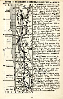 click to enlarge click to enlargeCTC288.jpg Strip road map, route 40, Borcovicus Greenhead Brampton Carlisle, part of Newcastle to Carlisle, scale roughly 5 miles to 1 inch. Together with an itinerary and gradient diagram. item:- JandMN : 491.88 Image © see bottom of page |
|||
|
|
||||
| evidence:- | old strip map:- CTC 1911 (Roads) |
|||
| source data:- | Page 90 of Cyclists' Touring Club British Road Book new series vol.6, edited by F
B Sandford, published by Thomas Nelson and Sons, London etc, 1911.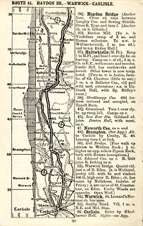 click to enlarge click to enlargeCTC290.jpg Strip road map, route 41, Haydon Bridge Warwick Carlisle, part of Newcastle to Carlisle, scale roughly 5 miles to 1 inch. Together with an itinerary and gradient diagram. item:- JandMN : 491.90 Image © see bottom of page |
|||
|
|
||||
 Act of Parliament Act of Parliament |
||||
|
|
||||
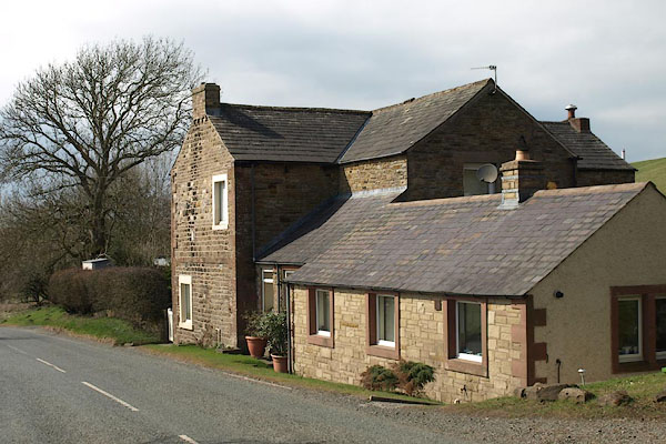
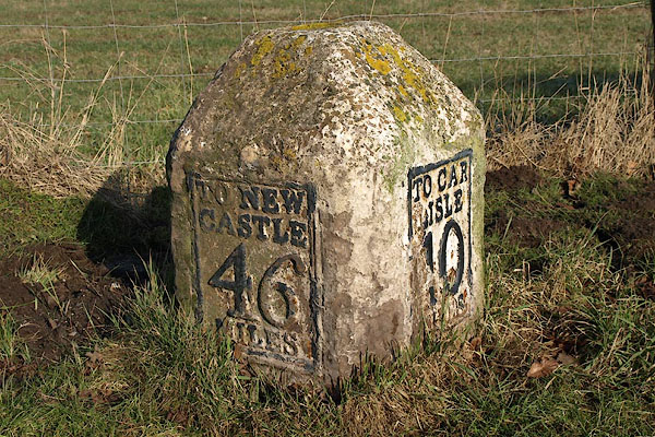
| places:- | Brampton Low Row, Nether Denton Greenhead, Northumberland Haltwhistle, Northumberland |
|||
|
|
||||
| places:- |
|
|||
|
||||
|
||||
|
||||
|
||||
|
||||
|
||||
Lakes Guides menu.