 Old Cumbria Gazetteer
 |
 |
|
| included in:- |
 Buttermere lake Buttermere lake |
|
| included in:- |
Crummock Water |
|
| viewpoint, Rannerdale Knotts | ||
| site name:- | Rannerdale Knotts | |
| civil parish:- | Buttermere (formerly Cumberland) | |
| county:- | Cumbria | |
| locality type:- | viewpoint | |
| coordinates:- | NY16251818 | |
| 1Km square:- | NY1618 | |
| 10Km square:- | NY11 | |
| SummaryText:- | Different writers have chosen different positions on the hillside to be their viewpoint. | |
|
|
||
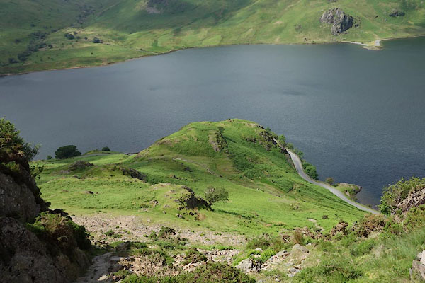 CAY05.jpg (taken 11.6.2014) 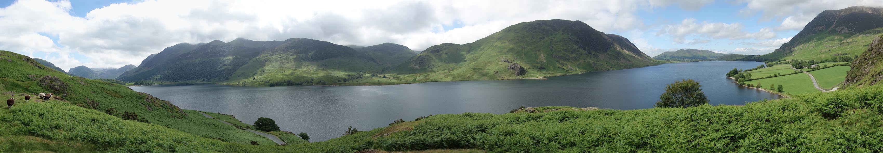 Click to enlarge CAY06.jpg Panorama from the viewpoint. (taken 11.6.2014) |
||
|
|
||
| evidence:- | descriptive text:- West 1778 (11th edn 1821) placename:- Randon Knot |
|
| source data:- | Guide book, A Guide to the Lakes, by Thomas West, published by
William Pennington, Kendal, Cumbria once Westmorland, and in
London, 1778 to 1821. goto source Page 138:- "..." "... From the crest of this rock [Randon-knot], the whole extent of the lake [Crummock Water] is discovered. On the western side the mountains rise immediately from the water's edge, bold and abrupt. Just in front, between Blea-crag and Mell-break, (two spiral hills) the hoarse resounding noise of a water-fall is heard across the lake, concealed within the bosom of the cliff, through which it has forced its way, and when viewed from the foot of the fall, is a most astonishing phaenomenon." "This lake is beautified with three small isles. One of rock lies just before you. The" goto sourcePage 139:- "whole eastern shore is diversified with bays, the banks with scattered trees, and a few inclosures, terminated by a hanging wood. At the foot of the lake, a high-crowned hill pushes forward, fringed with trees, and sweetly laid out with inclosures; and above it, on a cultivated slope, is the chapel of Lowes-water, surrounded with scattered farms. Behind all, Low-fell raises its verdant front; a sweet contrast to his murky neighbours, and a pleasing termination, either as seen from the top of this rock, or from the bosom of the lake." "The chain of pyramidal mountains on each side of this narrow vale, are extremely picturesque. They rise from distinct bases, and swell into the most grotesque forms of serrated or broken rocks." |
|
|
|
||
| evidence:- | old map:- Crosthwaite 1783-94 (But/Cru/Low) placename:- station, Hause Point placename:- station, Buttermere, Crosthwaite 4 |
|
| source data:- | Map, uncoloured engraving, An Accurate Map of Buttermere,
Crummock and Loweswater Lakes, scale about 3 inches to 1 mile,
by Peter Crosthwaite, Keswick, Cumberland, 1794, version
published 1800.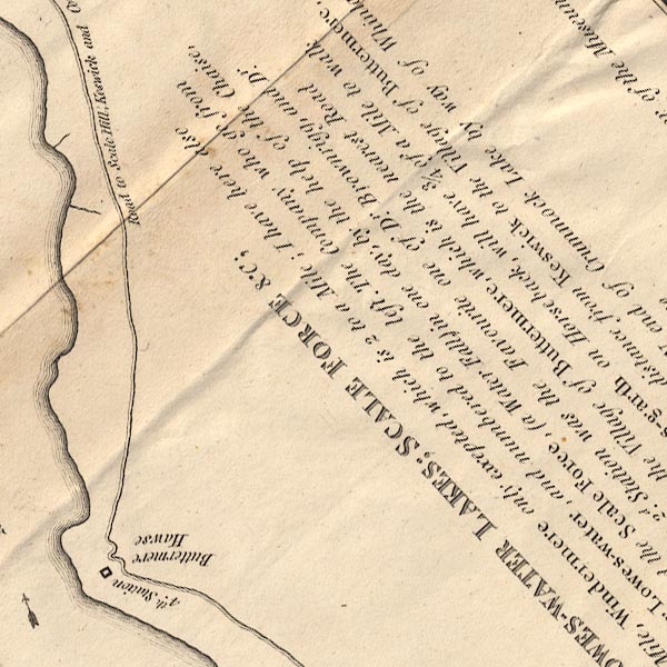 CT8NY11U.jpg "4th. Station / Buttermere Hawse" The viewpoint is marked between the road and the lake shore, ie below the road. item:- Armitt Library : 1959.191.2 Image © see bottom of page |
|
|
|
||
| evidence:- | descriptive text:- Otley 1823 (5th edn 1834) placename:- station, Hause Point |
|
| source data:- | Guide book, A Concise Description of the English Lakes, the
mountains in their vicinity, and the roads by which they may be
visited, with remarks on the mineralogy and geology of the
district, by Jonathan Otley, published by the author, Keswick,
Cumberland now Cumbria, by J Richardson, London, and by Arthur
Foster, Kirkby Lonsdale, Cumbria, 1823; published 1823-49,
latterly as the Descriptive Guide to the English Lakes. goto source Page 127:- "... a good view of Crummock Lake may be had, by riding a mile and a half on the eastern side, to a rocky point called the Hause. ..." |
|
|
|
||
Lakes Guides menu.