 Old Cumbria Gazetteer
 |
 |
|
| Uldale Mill, Ireby | ||
| Uldale Mill | ||
| Uldale Mill Farm | ||
| site name:- | Ellen, River | |
| civil parish:- | Ireby (formerly Cumberland) | |
| county:- | Cumbria | |
| locality type:- | buildings | |
| locality type:- | mill (ex) | |
| locality type:- | water mill | |
| locality type:- | corn mill | |
| coordinates:- | NY23983788 | |
| 1Km square:- | NY2337 | |
| 10Km square:- | NY23 | |
|
|
||
| evidence:- | old map:- OS County Series (Cmd 47 1) placename:- Uldale Mill |
|
| source data:- | Maps, County Series maps of Great Britain, scales 6 and 25
inches to 1 mile, published by the Ordnance Survey, Southampton,
Hampshire, from about 1863 to 1948. "Uldale Mill (Corn) / Sluice / Mill Race" |
|
|
|
||
| evidence:- | old map:- Donald 1774 (Cmd) |
|
| source data:- | Map, hand coloured engraving, 3x2 sheets, The County of Cumberland, scale about 1
inch to 1 mile, by Thomas Donald, engraved and published by Joseph Hodskinson, 29
Arundel Street, Strand, London, 1774.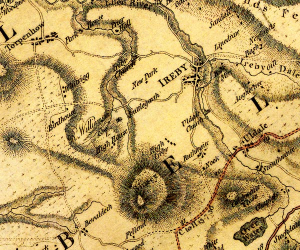 D4NY23NW.jpg circle with rays, mill wheel; a water mill at Uldale church item:- Carlisle Library : Map 2 Image © Carlisle Library |
|
|
|
||
| evidence:- | old print:- |
|
| source data:- | Print, uncoloured lithograph, Uldale, Cumberland, the mill? drawn by GC? early 20th
century?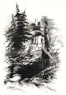 click to enlarge click to enlargePR0579.jpg printed at lower left:- "Uldale / Cumberland [GC]" item:- Dove Cottage : 2008.107.527 Image © see bottom of page |
|
|
|
||
 Lakes Guides menu.