 Old Cumbria Gazetteer
 |
 |
|
| Westward Forest | ||
| civil parish:- | Westward (formerly Cumberland) | |
| county:- | Cumbria | |
| locality type:- | forest | |
| 10Km square:- | NY34 (?) | |
| 1Km square:- | NY3040 | |
| 10Km square:- | NY34 | |
| references:- | Saxton 1579 |
|
|
|
||
| evidence:- | old map:- Saxton 1579 placename:- West Warde Forest |
|
| source data:- | Map, hand coloured engraving, Westmorlandiae et Cumberlandiae Comitatus ie Westmorland
and Cumberland, scale about 5 miles to 1 inch, by Christopher Saxton, London, engraved
by Augustinus Ryther, 1576, published 1579-1645.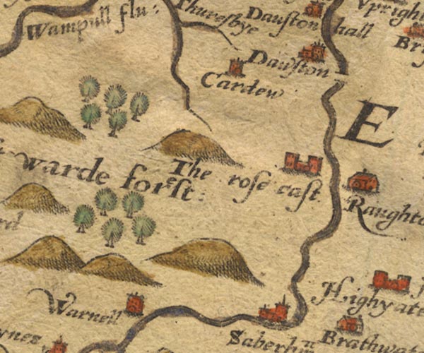 Sax9NY34.jpg "West Warde forest" item:- private collection : 2 Image © see bottom of page |
|
|
|
||
| evidence:- | old map:- Mercator 1595 (edn?) placename:- West Warde Forest |
|
| source data:- | Map, hand coloured engraving, Northumbria, Cumberlandia, et
Dunelmensis Episcopatus, ie Northumberland, Cumberland and
Durham etc, scale about 6.5 miles to 1 inch, by Gerard Mercator,
Duisberg, Germany, about 1595.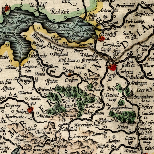 MER8CumC.jpg "West Warde forest" trees, tinted green; forest item:- JandMN : 169 Image © see bottom of page |
|
|
|
||
| evidence:- | old map:- Speed 1611 (Cmd) placename:- West Warde Forest |
|
| source data:- | Map, hand coloured engraving, Cumberland and the Ancient Citie
Carlile Described, scale about 4 miles to 1 inch, by John Speed,
1610, published by J Sudbury and George Humble, Popes Head
Alley, London, 1611-12.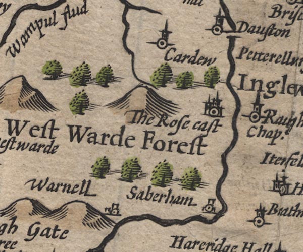 SP11NY34.jpg "West Warde Forest" groups of tree symbols item:- private collection : 16 Image © see bottom of page |
|
|
|
||
| evidence:- | poem:- Drayton 1612/1622 text placename:- Westward Forrest item:- mines |
|
| source data:- | Poem, Poly Olbion, by Michael Drayton, published by published by
John Marriott, John Grismand and Thomas Dewe, and others?
London, part 1 1612, part 2 1622. goto source goto sourcepage 166:- "... Shee [Eden] with two Wood-Nymphs meets, the first is great and wilde, And Westward Forrest hight, the other but a childe, Compared with her Phere, and Inglewood is cald, Both in their pleasant Scites, most happily instald." "What Sylvan is there seene, and be she nere so coy, Whose pleasures to the full, these Nymphs doe not enjoy, And like Dianas selfe, so truly living chaste For seldome any Tract, doth crosse their waylesse waste, With many a lustie leape, the shagged Satyrs show, Them pastime every day, both from the Meres below, And Hils on every side, that neatly hemme them in, The blushing morne to breake, but hardly doth begin, But that the ramping Goats, swift Deere, and harmlesse Sheepe, Which there their owners know, but no man hath to keepe, The Dales doe over-spread, by them like Motley made, But Westward of the two, by her more widened Slade. Of more abundance boasts, as of those mighty Mynes, Which in her Verge she hath: but that whereby she shines, Is her two daintie Floods, which from two Hils doe flow, Which in her selfe she hath, whose Banks doe bound her so Upon the North and South, as that she seemes to be Much pleased with their course, and takes delight to see How Elne upon the South, in sallying to the Sea Confines her: on the North how Wampull on her way," goto sourcepage 167:- "Her purlews wondrous large, yet limitteth againe, Both falling from her earth into the Irish Maine. No lesse is Westward proud of Waver, nor doth win Lesse praise by her cleere Spring, which in her course doth twin With Wiz, a neater Nymph scarce of the watry kind; And though she be but small, so pleasing Wavers mind, That they entirely mix'd, the Irish Seas imbrace, But earnestly proceed on our intended Race." |
|
|
|
||
| evidence:- | old map:- Drayton 1612/1622 placename:- |
|
| source data:- | Map, hand coloured engraving, Cumberlande and Westmorlande, by
Michael Drayton, probably engraved by William Hole, scale about
4 or 5 miles to 1 inch, published by John Mariott, John
Grismand, and Thomas Dewe, London, 1622.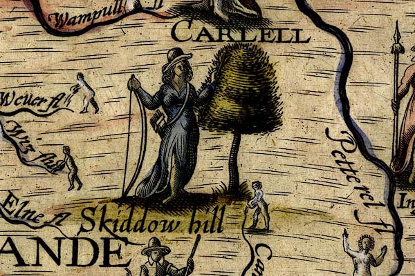 DRY507.jpg Tree and a huntress with a bow and arrows; a forest. item:- JandMN : 168 Image © see bottom of page |
|
|
|
||
| evidence:- | probably old map:- Jansson 1646 placename:- West Warde Forest |
|
| source data:- | Map, hand coloured engraving, Cumbria and Westmoria, ie
Cumberland and Westmorland, scale about 3.5 miles to 1 inch, by
John Jansson, Amsterdam, Netherlands, 1646.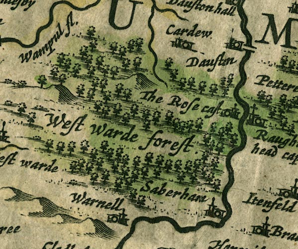 JAN3NY34.jpg "West Warde forest" Large group of tree symbols. item:- JandMN : 88 Image © see bottom of page |
|
|
|
||
| evidence:- | old map:- Morden 1695 (Cmd) placename:- West Ward Forest |
|
| source data:- | Map, uncoloured engraving, Cumberland, scale about 4 miles to 1
inch, by Robert Morden, 1695, published by Abel Swale, the
Unicorn, St Paul's Churchyard, Awnsham, and John Churchill, the
Black Swan, Paternoster Row, London, 1695-1715.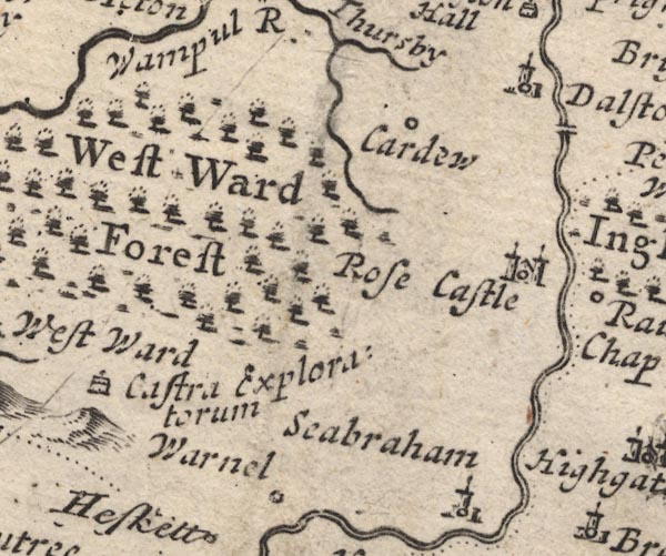 MD12NY34.jpg "West Ward Forest" Forest, tree symbols. item:- JandMN : 90 Image © see bottom of page |
|
|
|
||
| evidence:- | old map:- Badeslade 1742 placename:- Westward Forest |
|
| source data:- | Map, uncoloured engraving, A Map of Cumberland North from
London, scale about 11 miles to 1 inch, with descriptive text,
by Thomas Badeslade, London, engraved and published by William
Henry Toms, Union Court, Holborn, London, 1742. click to enlarge click to enlargeBD10.jpg "Westward forest" trees item:- JandMN : 115 Image © see bottom of page |
|
|
|
||
| evidence:- | old map:- Bickham 1753-54 (Cmd) placename:- Westwood Forrest |
|
| source data:- | Map, uncoloured engraving, perspective map, Map of Cumberland
North from London, by George Bickham, James Street, Bunhill
Fields, London, 1753, published by F Jollie and Sons, Carlisle,
Cumberland, 1811.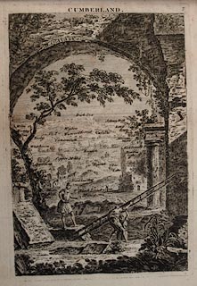 click to enlarge click to enlargeJL05.jpg "Westwood Forrest" view (sort of) item:- Carlisle Library : 4.2 Image © Carlisle Library |
|
|
|
||
| evidence:- | old map:- Bowen and Kitchin 1760 placename:- Westward Forest |
|
| source data:- | Map, hand coloured engraving, A New Map of the Counties of
Cumberland and Westmoreland Divided into their Respective Wards,
scale about 4 miles to 1 inch, by Emanuel Bowen and Thomas
Kitchin et al, published by T Bowles, Robert Sayer, and John
Bowles, London, 1760.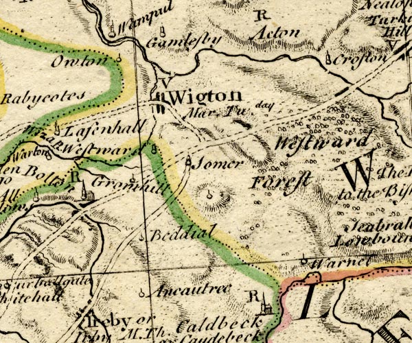 BO18NY24.jpg "Westward Forest" trees item:- Armitt Library : 2008.14.10 Image © see bottom of page |
|
|
|
||
| see:- | Park Wood, Westward |
|
|
|
||
Lakes Guides menu.