 Old Cumbria Gazetteer
 |
 |
|
| Whiteless Pike, Buttermere | ||
| Whiteless Pike | ||
| civil parish:- | Buttermere (formerly Cumberland) | |
| county:- | Cumbria | |
| locality type:- | hill | |
| coordinates:- | NY180189 | |
| 1Km square:- | NY1818 | |
| 10Km square:- | NY11 | |
|
|
||
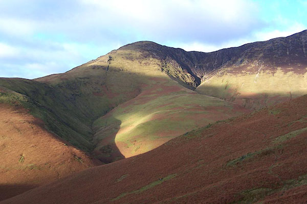 BLM44.jpg From the path up Knott Rigg from Newlands Hause. (taken 25.12.2005) 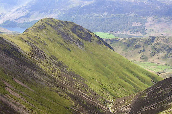 BNP73.jpg (taken 26.4.2007) |
||
|
|
||
| evidence:- | old map:- OS County Series (Cmd 69 2) placename:- Whiteless Pike |
|
| source data:- | Maps, County Series maps of Great Britain, scales 6 and 25
inches to 1 mile, published by the Ordnance Survey, Southampton,
Hampshire, from about 1863 to 1948. |
|
|
|
||
| evidence:- | old map:- Gents Mag 1751 placename:- Whitedales Pike |
|
| source data:- | Map, uncoloured engraving, Map of the Black Lead Mines in
Cumberland, and area, scale about 2 miles to 1 inch, by George
Smith, published in the Gentleman's Magazine, 1751.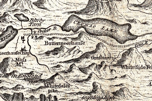 GM1306.jpg "Whitedales pike" knobbly hillocks; mountains item:- JandMN : 114 Image © see bottom of page |
|
|
|
||
| evidence:- | old map:- Otley 1818 placename:- Whiteless |
|
| source data:- | Map, uncoloured engraving, The District of the Lakes,
Cumberland, Westmorland, and Lancashire, scale about 4 miles to
1 inch, by Jonathan Otley, 1818, engraved by J and G Menzies,
Edinburgh, Scotland, published by Jonathan Otley, Keswick,
Cumberland, et al, 1833.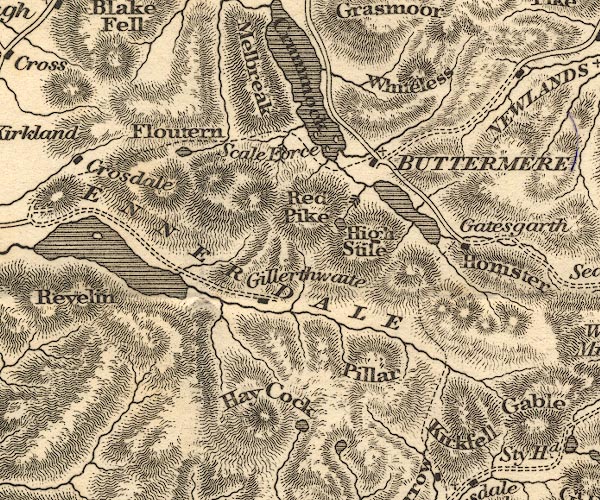 OT02NY11.jpg item:- JandMN : 48.1 Image © see bottom of page |
|
|
|
||
| evidence:- | outline view:- Otley 1823 (4th edn 1830) placename:- Witeless Pike |
|
| source data:- | Print, engraving, outline view, Some of the Western Mountains as seen from Helvellyn,
published by Jonathan Otley, Keswick, Cumberland et al, 1830.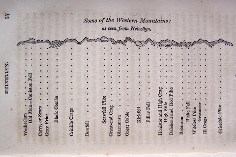 click to enlarge click to enlargeO75E02.jpg p.57 in A Concise Description of the English Lakes, by Jonathan Otley, 4th edition, 1830. "Some of the Western Mountains: / as seen from Helvellyn." "Wetherlam / Old Man - Coniston Fell / Carrs, or Scars / Gray Friar / Black Combe / Crinkle Crags / Bowfell / Scawfell Pike / Great-end Crag / Glaramara / Great Gable / Kirkfell / Pillar Fell / Honister and High Crag / High Stile / Dalehead and Red Pike / Robinson / Blake Fell / Witeless Pike / Grasmoor / Ill Crags / Grisedale Pike" item:- Armitt Library : A1175.3 Image © see bottom of page |
|
|
|
||
| evidence:- | outline view:- Otley 1823 (4th edn 1830) placename:- Witeless Pike |
|
| source data:- | Print, engraving, outline view, The Mountains of Crummock and Buttermere as seen on
the Road between Scale-Hill and Loweswater, published by Jonathan Otley, Keswick,
Cumberland et al, 1830.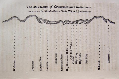 click to enlarge click to enlargeO75E07.jpg p.125 in A Concise Description of the English Lakes, by Jonathan Otley, 4th edition, 1830. "The Mountains of Crummock and Buttermere: / as seen on the Road between Scale-Hill and Loweswater." "Whiteside / Grasmoor / Witeless Pike / Robinson / Fleetworth / Rannerdale Knot / Hay Stacks and Gable / Cold Kell Wyke / Kirkfell / High Crag / High Stile / Red Pike / Melbreak / Hencomb" item:- Armitt Library : A1175.7 Image © see bottom of page |
|
|
|
||
| evidence:- | outline view:- Otley 1823 (8th edn 1849) placename:- Witeless Pike placename:- Whiteless Pike |
|
| source data:- | Engraving, outline view of mountains, Crummock and Buttermere from the Road near Loweswater
Church, drawn by T Binns, engraved by O Jewitt, opposite p.18 of A Descriptive Guide
of the English Lakes, by Jonathan Otley, 8th edition, 1849.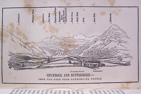 click to enlarge click to enlargeO80E10.jpg item:- Armitt Library : A1180.11 Image © see bottom of page |
|
|
|
||
| evidence:- | outline view:- Otley 1823 (8th edn 1849) placename:- Witeless Pike placename:- Whiteless Pike |
|
| source data:- | Engraving, outline view of mountains, A Group of Mountains seen from Helvellyn, looking
towards the South West, drawn by T Binns, engraved by O Jewitt, opposite p.50 of A
Descriptive Guide of the English Lakes, by Jonathan Otley, 8th edition, 1849.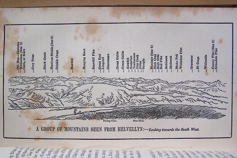 click to enlarge click to enlargeO80E17.jpg item:- Armitt Library : A1180.18 Image © see bottom of page |
|
|
|
||
| evidence:- | outline view:- Otley 1823 (5th edn 1834) placename:- Witeless Pike |
|
| source data:- | Print, woodcut outline view, The Mountains of Crummock and
Buttermere, by Jonathan Otley, Keswick, Cumberland, 1830.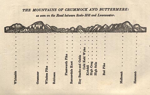 click to enlarge click to enlargeOT2E05.jpg Printed on p.25 of A Concise Description of the English Lakes, by Jonathan Otley, 5th edition, 1834. "THE MOUNTAINS OF CRUMMOCK AND BUTTERMERE: as seen on the Road between Scale-Hill and Loweswater." "Whiteside / Grasmoor / Witeless Pike / Robinson / Fleetworth Pike / Rannerdale Knot / Hay Stacks and Gable / Cold Keld Wyke / Kirkfell / High Crag / High Stile / Red Pike / Melbreak / Hencomb" item:- JandMN : 48.6 Image © see bottom of page |
|
|
|
||
| evidence:- | outline view:- Otley 1823 (5th edn 1834) placename:- Witeless Pike |
|
| source data:- | Print, woodcut outline view, A Group of Mountains, seen from
Helvellyn, by Jonathan Otley, Keswick, Cumberland, 1830.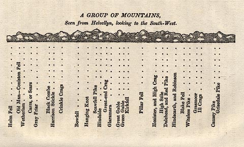 click to enlarge click to enlargeOT2E09.jpg Printed on p.63 of A Concise Description of the English Lakes, by Jonathan Otley, 5th edition, 1834. "A GROUP OF MOUNTAINS, Seen from Helvellyn, looking to the South-West." "Holm Fell / Old Man - Coniston Fell / Wetherlam / Carrs, or Scars / Gray Friar / Black Combe / Harrison Stickle / Crinkle Crags / Bowfell / Hanging Knot / Scawfell Pike / Hindside / Great-end Crag / Glaramara / Great Gable / Green Gable / Kirkfell / Pillar Fell / Honister, and High Crag / High Stile / Dalehead, and Red Pike / Hindscarth, and Robinson / Blake Fell / Witeless Pike / Grasmoor / Ill Crags / Causey Pike / Grisedale Pike" item:- JandMN : 48.10 Image © see bottom of page |
|
|
|
||
| evidence:- | descriptive text:- Otley 1823 (5th edn 1834) placename:- Witeless Pike |
|
| source data:- | Print, woodcut outline view, The Mountains of Crummock and
Buttermere, by Jonathan Otley, Keswick, Cumberland, 1830. goto source goto sourcePage 76:- "WITELESS PIKE" "Is attached to the mountain Grasmoor, and rises with a steep ascent to the height of nearly 2000 feet above Buttermere. It commands excellent views of the three lakes of Buttermere, Crummock, and Loweswater; with the summits of the principal mountains from Helvellyn to those of Borrowdale, Wasdale, Ennerdale, and Buttermere. The Isle of Man is also in sight, and a considerable portion of the shires of Kirkcudbright and Wigton in Scotland." item:- JandMN : 48.6 Image © see bottom of page |
|
|
|
||
| evidence:- | old map:- Garnett 1850s-60s H placename:- Whiteless |
|
| source data:- | Map of the English Lakes, in Cumberland, Westmorland and
Lancashire, scale about 3.5 miles to 1 inch, published by John
Garnett, Windermere, Westmorland, 1850s-60s. GAR2NY11.jpg "Whiteless" hill hachuring item:- JandMN : 82.1 Image © see bottom of page |
|
|
|
||
| evidence:- | old text:- Martineau 1855 placename:- Whitelees |
|
| source data:- | Guide book, A Complete Guide to the English Lakes, by Harriet
Martineau, published by John Garnett, Windermere, Westmorland,
and by Whittaker and Co, London, 1855; published 1855-76. goto source Page 84:- "... The opposite side of the hollow [descending into Buttermere] is formed by the mountain Whitelees. ..." |
|
|
|
||
| evidence:- | outline view:- Martineau 1855 |
|
| source data:- | Print, engraving, outline view, Mountains seen from Lanthwaite Wood Crummock Water,
drawn by L Aspland, engraved by W Banks, Edinburgh, published by John Garnett, Windermere,
Westmorland, and by Whittaker and Co, London, 1855.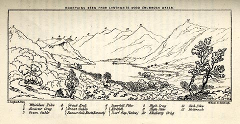 click to enlarge click to enlargeMNU113.jpg Opposite p.84 in A Complete Guide to the English Lakes, by Harriet Martineau. The view is captioned, numbers referring to mountains in the image:- "1 Whiteless Pike, 2 Honister Crag, 3 Green Gable, 4 Great End, 5 Great Gable / Rannerdale Knott (beneath), 6 Scawfell Pike, 7 Kirkfell / Scarf Gap (below), 8 High Crag, 9 High Stile, 10 Bleaberry Crag, 11 Red Pike, 12 Melbreak." "MOUNTAINS SEEN FROM LANTHWAITE WOOD CRUMMOCK WATER." "L Aspland Delt. / W Banks Sc Edinr." item:- Armitt Library : A1159.13 Image © see bottom of page |
|
|
|
||
| evidence:- | old print:- Brabant 1902 placename:- Whiteless Pike |
|
| source data:- | Print, uncoloured lithograph, Crummock Water and Whiteless Pike, Buttermere, Cumberland,
by Edmund H New, published by Methuen and Co, 36 Essex Street, Strand, London, 1902.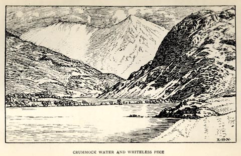 click to enlarge click to enlargeBBT112.jpg Tipped in opposite p.300 of The English Lakes, by F G Brabant. printed at bottom right:- "E. H. N." printed at bottom:- "CRUMMOCK WATER AND WHITELESS PIKE" item:- JandMN : 502.21 Image © see bottom of page |
|
|
|
||
| evidence:- | outline view:- Jenkinson 1875 placename:- Whiteless Pike |
|
| source data:- | Print, lithograph, outline view, Panoramic Sketches from Helvellyn, Westmorland, by
Edwin A Pettitt, London, published by Edward Stanford, 55 Charing Cross, London, 1875.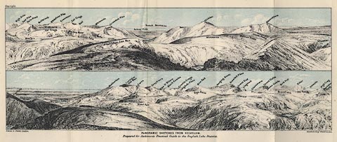 click to enlarge click to enlargeJk01E1.jpg "... Whiteless Pike ..." item:- JandMN : 28.5 Image © see bottom of page |
|
|
|
||
| evidence:- | outline view:- Jenkinson 1875 placename:- Whiteless Pike |
|
| source data:- | Print, lithograph, outline view, Panoramic Sketches from Scawfell Pike, Cumberland,
by Edwin A Pettitt, London, published by Edward Stanford, 55 Charing Cross, London,
1875.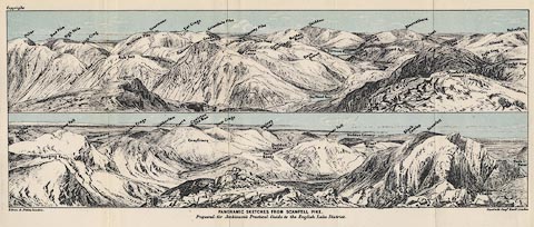 click to enlarge click to enlargeJk01E3.jpg "... Whiteless Pike ..." item:- JandMN : 28.9 Image © see bottom of page |
|
|
|
||
| evidence:- | outline view:- Tattersall 1836 (version 1869) placename:- Whiteless |
|
| source data:- | Print, hand coloured, Loweswater, from the North West, Cumberland, drawn by George
Tattersall, 1836, engraved by W F Topham, published by T J Allman, 463 Oxford Street,
London, 1869.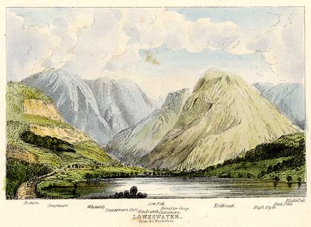 click to enlarge click to enlargeTAT216.jpg Included in The Lakes of England, by W F Topham. printed at bottom:- "LOWESWATER, / from the North West." printed at bottom:- "Bottom. / Grasmoor. / Whiteless. / Buttermere Moss. / Hindscarth. / Low Fell. / Glaramara. / Honister Crag. / Melbreak. / High Style. / Red Pike. / Blake Fell." item:- Armitt Library : A1067.16 Image © see bottom of page |
|
|
|
||
| evidence:- | outline view:- Tattersall 1836 placename:- Whiteless |
|
| source data:- | Print, engraving, Loweswater from the North West, Cumberland, drawn by George Tattersall,
engraved by W F Topham, published by Sherwood and Co, Paternoster Row, London, about
1836.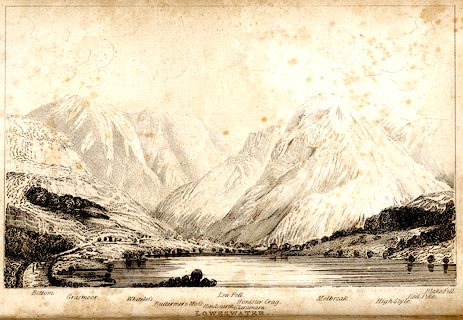 click to enlarge click to enlargeTAT134.jpg The print is captioned with mountain names and acts as an outline view. Frontispiece to The Lakes of England, by George Tattersall (listed to be inserted opposite p.35). printed at bottom:- "LOWESWATER. / from the North West." printed at bottom left to right:- "Bottom. / Grasmoor. / Whiteless. / Buttermere &Moss. / Hindscarth. / Low Fell. / Glaramara. / Honister Crag. / Melbreak. / High Style. / Red Pike. / Blake Fell." item:- Armitt Library : A1204.35 Image © see bottom of page |
|
|
|
||
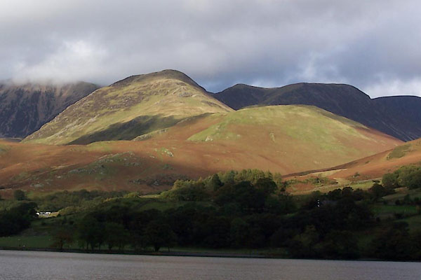 BXM40.jpg (taken 6.10.2012) 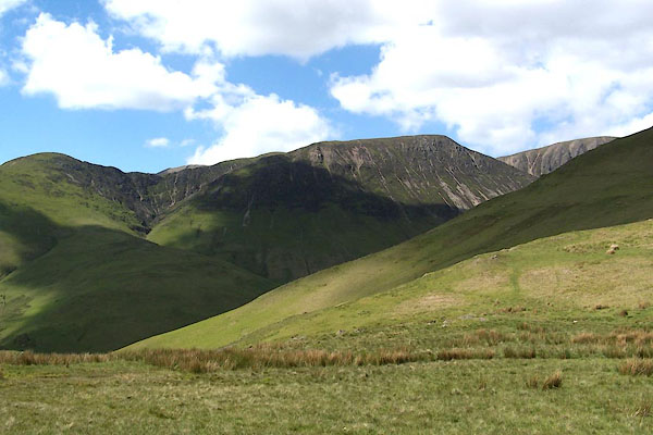 BJQ11.jpg (taken 10.6.2005) 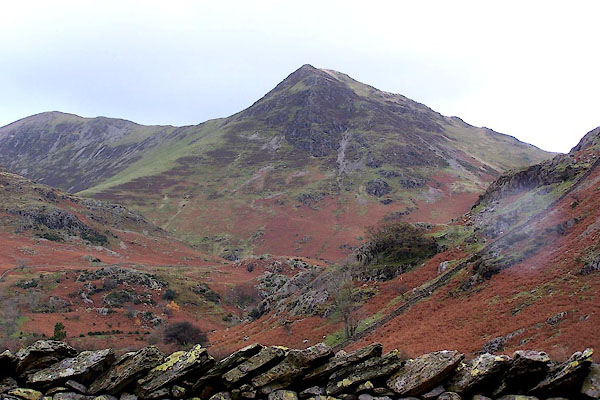 BJZ35.jpg (taken 7.11.2005) 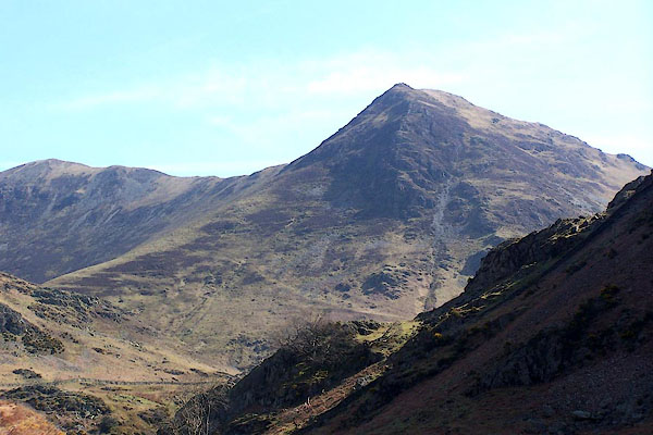 BLY27.jpg (taken 24.4.2006) 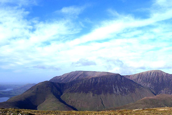 BNE28.jpg Whiteless Pike; Grasmoor and Wandhope; Crag Hill (taken 14.2.2007) 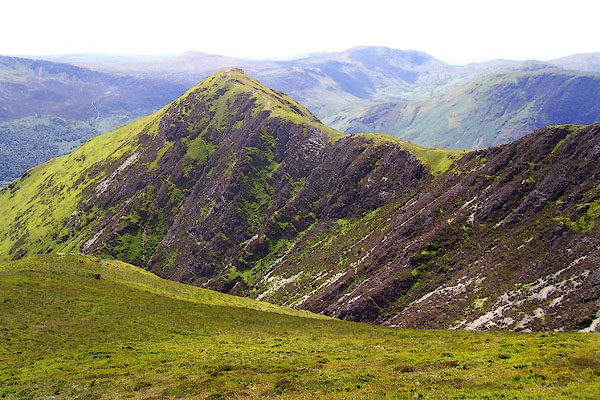 BPJ48.jpg (taken 23.6.2008) 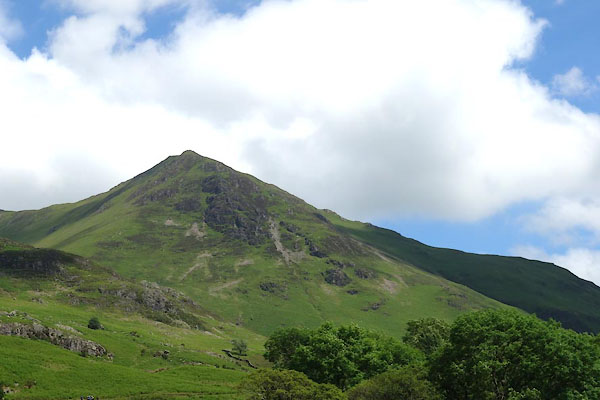 CAY31.jpg (taken 11.6.2014) |
||
|
|
||
Lakes Guides menu.