 Old Cumbria Gazetteer
 |
 |
|
| College, Kirkoswald | ||
| Kirkoswald College | ||
| locality:- | Kirkoswald | |
| civil parish:- | Kirkoswald (formerly Cumberland) | |
| county:- | Cumbria | |
| locality type:- | buildings | |
| coordinates:- | NY55474109 | |
| 1Km square:- | NY5541 | |
| 10Km square:- | NY54 | |
|
|
||
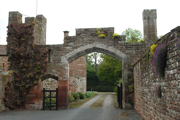 BUL13.jpg Gate to The College. (taken 29.4.2011) |
||
|
|
||
| evidence:- | old map:- OS County Series (Cmd 40 6) placename:- College |
|
| source data:- | Maps, County Series maps of Great Britain, scales 6 and 25
inches to 1 mile, published by the Ordnance Survey, Southampton,
Hampshire, from about 1863 to 1948. |
|
|
|
||
| evidence:- | map:- |
|
| source data:- | : 1954: Monastic Britain: Ordnance Survey | |
|
|
||
| evidence:- | old text:- Pennant 1773 |
|
| source data:- | Book, A Tour from Downing to Alston Moor, 1773, by Thomas
Pennant, published by Edward Harding, 98 Pall Mall, London, 1801. goto source goto sourcePennant's Tour 1773, page 169 "Not long before the dissolution, the church was turned into a College of twelve Secular Priests. All the glebe-lands and tithes are the property of the old family of the Featherstonhaughs. The college was converted into a mansion-house by that family, and was called by Mr. Sandford a noble one." |
|
|
|
||
| evidence:- | old map:- Donald 1774 (Cmd) placename:- College |
|
| source data:- | Map, hand coloured engraving, 3x2 sheets, The County of Cumberland, scale about 1
inch to 1 mile, by Thomas Donald, engraved and published by Joseph Hodskinson, 29
Arundel Street, Strand, London, 1774.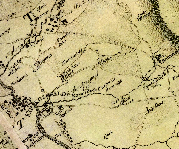 D4NY54SE.jpg "College / Featherstonhaugh Esqr." house item:- Carlisle Library : Map 2 Image © Carlisle Library |
|
|
|
||
| evidence:- | old text:- Camden 1789 (Gough Additions) item:- placename, Fetherstonhaugh |
|
| source data:- | Book, Britannia, or A Chorographical Description of the Flourishing Kingdoms of England,
Scotland, and Ireland, by William Camden, 1586, translated from the 1607 Latin edition
by Richard Gough, published London, 1789. goto source Page 190:- "..." ""... and quondam college: now the noble mansion-house of the late sir Timothy Fetherstonhaugh, colonel of the king's side, taken at Wigan when the late lord Witherington was slain. Sir Timothy was taken prisoner and excuted by beheading at Chester, by the command of the unworthy col. Mitton, after the said knight had quarter given him. ..." goto sourcePage 191:- "..." "The Fetherstonhaughs were a Northumberland family, whose antient seat was at a place of that name. Their house, it is said, was formerly on a hill (where are two stones called Fether stones), and was moated about for defence against the Scots. But, upon the ruin of this, the house was afterwards built in the holme or valley under the hill, which they there call haugh, and the family writ their names de Fetherston, and sometimes de Fetherstonhaugh. They first came to Kirk Oswald in the beginning of the last century, where they yet continue." |
|
|
|
||
| evidence:- | road book:- Cary 1798 (2nd edn 1802) placename:- College, The |
|
| source data:- | Road book, itineraries, Cary's New Itinerary, by John Cary, 181
Strand, London, 2nd edn 1802. goto source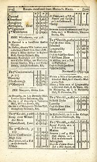 click to enlarge click to enlargeC38319.jpg page 319-320 "At Kirkoswald on l. is the College, C. Featherstonhaugh, Esq." item:- JandMN : 228.1 Image © see bottom of page |
|
|
|
||
| evidence:- | old text:- Capper 1808 |
|
| source data:- | Gazetteer, A Topographical Dictionary of the United Kingdom,
compiled by Benjamin Pitts Capper, published by Richard
Phillips, Bridge Street, Blackfriars, London, 1808; published
1808-29. goto source "[Kirkoswald] ... In the reign of Henry VIII. a college was founded here for 12 priests. ..." |
|
|
|
||
| evidence:- | database:- Listed Buildings 2010 placename:- College |
|
| source data:- | courtesy of English Heritage "THE COLLEGE AND ADJOINING UNNAMED HOUSE / / / KIRKOSWALD / EDEN / CUMBRIA / II / 73496 / NY5970443520" |
|
|
|
||
| evidence:- | database:- Listed Buildings 2010 placename:- College Flat item:- date stone |
|
| source data:- | courtesy of English Heritage "THE COLLEGE FLAT, SOUTH OF THE COLLEGE / / / KIRKOSWALD / EDEN / CUMBRIA / II / 73483 / NY5548141093" |
|
|
|
||
| evidence:- | database:- Listed Buildings 2010 placename:- College, The item:- coat of arms; date stone (1696); date stone (1842) |
|
| source data:- | courtesy of English Heritage "THE COLLEGE / / / KIRKOSWALD / EDEN / CUMBRIA / I / 73482 / NY5545641109" |
|
|
|
||
| evidence:- | database:- Listed Buildings 2010 |
|
| source data:- | courtesy of English Heritage "ENTRANCE GATEWAY SOUTH EAST OF THE COLLEGE / / / KIRKOSWALD / EDEN / CUMBRIA / II / 73485 / NY5548841066" |
|
|
|
||
| evidence:- | database:- Listed Buildings 2010 |
|
| source data:- | courtesy of English Heritage "STABLE BLOCK SOUTH OF THE COLLEGE / / / KIRKOSWALD / EDEN / CUMBRIA / II / 73484 / NY5546541082" |
|
|
|
||
| evidence:- | database:- Listed Buildings 2010 item:- sundial |
|
| source data:- | courtesy of English Heritage "TERRACE WALL AND STEPS WEST OF THE COLLEGE / / / KIRKOSWALD / EDEN / CUMBRIA / II / 73486 / NY5544041103" |
|
|
|
||
| evidence:- | site plan:- placename:- College, The |
|
| source data:- | Plan, uncoloured lithograph, The College, Kirkoswald, Cumberland, published by Cumberland
and Westmorland Antiquarian and Archaeological Society, Kendal, Westmorland, 1914.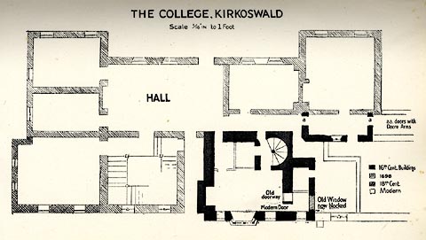 click to enlarge click to enlargePR1554.jpg With an article about the Fetherstonhaugh Family and The College, by Mrs Fetherstonhaugh and F Haswell. printed at upper centre:- "THE COLLEGE, KIRKOSWALD" item:- private collection : 232 Image © see bottom of page |
|
|
|
||
| hearsay:- |
The house was established as a college for priests in 1523. It is built onto a pele
tower. After The Dissolution the College was the home of the Fetherstonhaugh Family. |
|
|
|
||
| notes:- |
15th century tower included in the later building |
|
| Perriam, D R &Robinson, J: 1998: Medieval Fortified Buildings of Cumbria: CWAAS::
ISBN 1 873124 23 6; plan and illustration |
||
|
|
||
Lakes Guides menu.