 Old Cumbria Gazetteer
 |
 |
|
||
| road, Keswick to Carlisle | ||||
| Keswick to Carlisle | ||||
| Carlisle to Keswick | ||||
| locality:- | Keswick | |||
| civil parish:- | Keswick (formerly Cumberland) | |||
| county:- | Cumbria | |||
| locality type:- | route | |||
| locality:- | Carlisle | |||
| civil parish:- | Carlisle (formerly Cumberland) | |||
| county:- | Cumbria | |||
| locality type:- | route | |||
|
|
||||
| route parts:- |  Keswick to Cockermouth, as far as Bassenthwaite Bassenthwaite to Bothel Cockermouth to Carlisle, from Bothel Keswick to Cockermouth, as far as Bassenthwaite Bassenthwaite to Bothel Cockermouth to Carlisle, from Bothel |
|||
|
|
||||
| route parts:- | alternative route Keswick to Cockermouth, as far as Bassenthwaite Bassenthwaite to Red Dial Cockermouth to Carlisle, from Red Dial |
|||
|
|
||||
| evidence:- | old map:- Donald 1774 (Cmd) |
|||
| source data:- | Map, hand coloured engraving, 3x2 sheets, The County of Cumberland, scale about 1
inch to 1 mile, by Thomas Donald, engraved and published by Joseph Hodskinson, 29
Arundel Street, Strand, London, 1774. double line, solid or dotted, with a dot or milestone and number at 1 mile intervals, tinted red; turnpike road 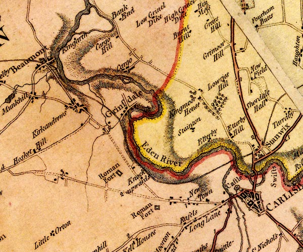 D4NY35NE.jpg 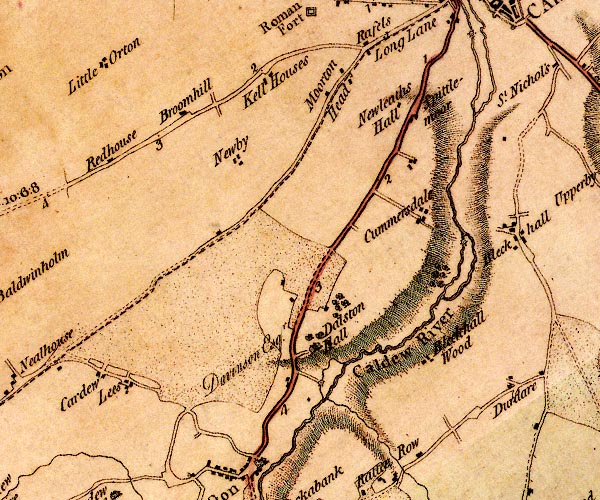 D4NY35SE.jpg 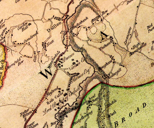 D4NY34NE.jpg 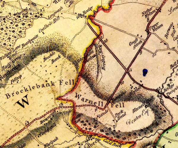 D4NY34SW.jpg 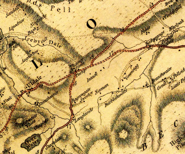 D4NY23NE.jpg 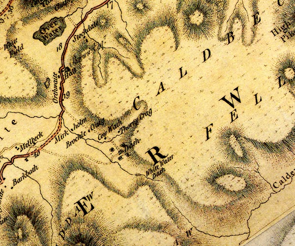 D4NY23SE.jpg 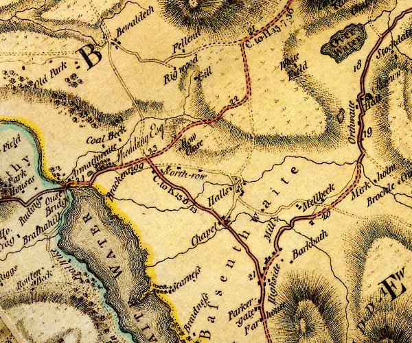 D4NY23SW.jpg 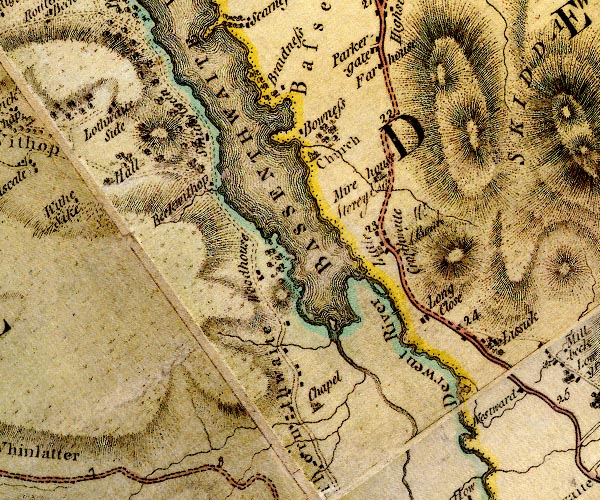 D4NY22NW.jpg 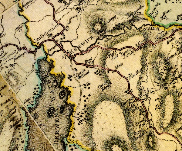 D4NY22SE.jpg item:- Carlisle Library : Map 2 Images © Carlisle Library |
|||
|
|
||||
| evidence:- | road book:- Cary 1798 (2nd edn 1802) |
|||
| source data:- | Road book, itineraries, Cary's New Itinerary, by John Cary, 181
Strand, London, 2nd edn 1802. goto source goto source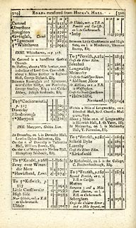 click to enlarge click to enlargeC38319.jpg page 319-320 item:- JandMN : 228.1 Image © see bottom of page |
|||
|
|
||||
| evidence:- | road book:- Cary 1798 (2nd edn 1802) |
|||
| source data:- | Road book, itineraries, Cary's New Itinerary, by John Cary, 181
Strand, London, 2nd edn 1802. goto source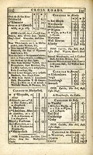 click to enlarge click to enlargeC38555.jpg page 555-556 "CARLISLE to Ireby." part of goto source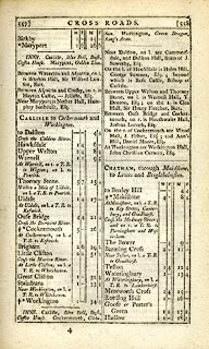 click to enlarge click to enlargeC38557.jpg page 557-558 "At Uldale, on l. a T.R. to Keswick." item:- JandMN : 228.2 Image © see bottom of page |
|||
|
|
||||
| evidence:- | old map:- Laurie and Whittle 1806 |
|||
| source data:- | Road map, Completion of the Roads to the Lakes, scale about 10
miles to 1 inch, by Nathaniel Coltman? 1806, published by Robert
H Laurie, 53 Fleet Street, London, 1834. click to enlarge click to enlargeLw18.jpg bold line; 'Principal Travelling Roads' item:- private collection : 18.18 Image © see bottom of page |
|||
|
|
||||
| evidence:- | old map:- Hall 1820 (Cmd) |
|||
| source data:- | Map, hand coloured engraving, Cumberland, scale about 21 miles
to 1 inch, engraved by Sidney Hall, published by S Leigh, 18
Strand, London, 1820-31. click to enlarge click to enlargeHA14.jpg single line, solid; minor road; Keswick, HIghside, Up Welton, Hawksdale, Dalston, Carlisle item:- JandMN : 91 Image © see bottom of page |
|||
|
|
||||
| evidence:- | old map:- Ford 1839 map |
|||
| source data:- | Map, uncoloured engraving, Map of the Lake District of
Cumberland, Westmoreland and Lancashire, scale about 3.5 miles
to 1 inch, published by Charles Thurnam, Carlisle, and by R
Groombridge, 5 Paternoster Row, London, 3rd edn 1843.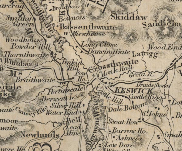 FD02NY22.jpg 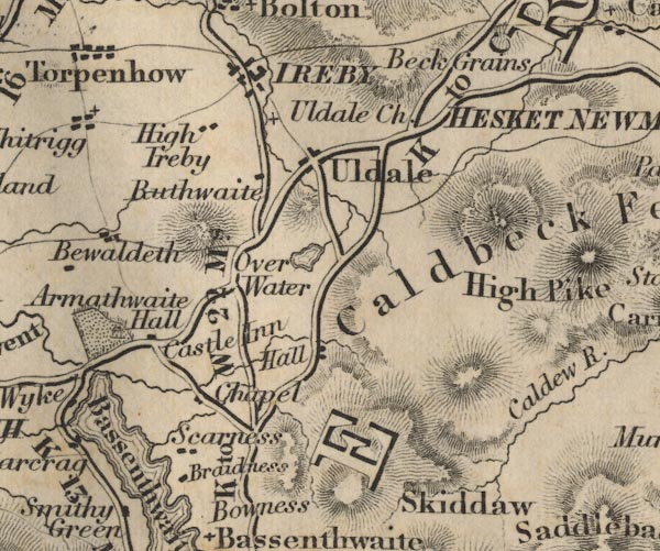 FD02NY23.jpg "K to C 27 Ms." 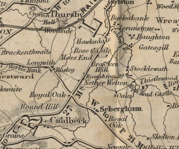 FD02NY34.jpg "K to C 27 Ms." 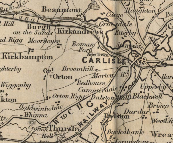 FD02NY35.jpg item:- JandMN : 100.1 Image © see bottom of page |
|||
|
|
||||
| evidence:- | old itinerary:- Johnson 1908 (Roads/Cum) |
|||
| source data:- | Itinerary, Route 42 in Roads Made Easy by Picture and Pen, Kendal to Carlisle, through
The Lakes, by Claude Johnson, edited by Lord Montagu, published by The Car Illustrated,
168 Piccadilly, London, 1908.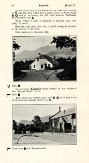 click to enlarge click to enlargeJS5086.jpg pp.85-88 in the road book, Roads Made Easy by Picture and Pen, vol.3. printed at beginning, p.85:- "ROUTE 42. / KENDAL via the Lakes, Windermere (8¼), Grasmere (17), Dunmail Raise (20¼), Thirlmere, Keswick (30), Bothel (42¾), to CARLISLE (61¼)." 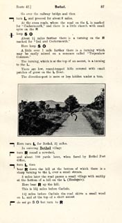 click to enlarge click to enlargeJS5087.jpg 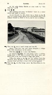 click to enlarge click to enlargeJS5088.jpg item:- private collection : 268.12 Image © see bottom of page |
|||
|
|
||||
| evidence:- | old itinerary:- Johnson 1908 (Roads/Cum) |
|||
| source data:- | Itinerary, Route 42 reverse in Roads Made Easy by Picture and Pen, Carlisle to Kendal,
through The Lakes, by Claude Johnson, edited by Lord Montagu, published by The Car
Illustrated, 168 Piccadilly, London, 1908.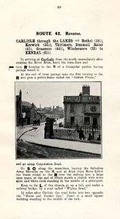 click to enlarge click to enlargeJS5089.jpg pp.89-92 in the road book, Roads Made Easy by Picture and Pen, vol.3. printed at beginning, p.89:- "ROUTE 42. Reverse. / CARLISLE through the Lakes via Bothel (18½), Keswick (31¼), Thirlmere, Dunmail Raise (41), Grasmere (44¼), Windermere (53) to KENDAL (61¼)." 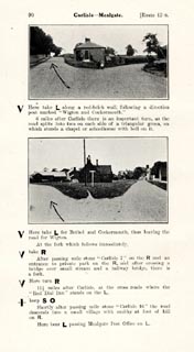 click to enlarge click to enlargeJS5090.jpg 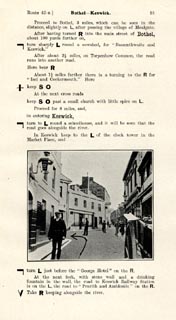 click to enlarge click to enlargeJS5091.jpg item:- private collection : 268.13 Image © see bottom of page |
|||
|
|
||||
| evidence:- | gradient diagram:- Watson 1912 |
|||
| source data:- | Gradient diagram, black and white halftone, roads from Keswick, Cumberland, in a guide
book, Keswick on Derwentwater, published by George Watson, after 1913.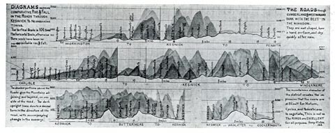 click to enlarge click to enlargeWT4Gd.jpg item:- Keswick Museum : 2145.5 Image © see bottom of page |
|||
|
|
||||
| evidence:- | old strip map:- Geographia 1925 |
|||
| source data:- | Road book, with road strip maps and gradient diagrams, Premier Road Book of Great
Britain, by Alexander Gross and F Waite-Browne, published by Geographia, 55 Fleet
Street, London, about 1925?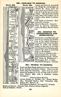 click to enlarge click to enlargeGE1102.jpg "248. - CARLISLE TO KESWICK." item:- Hampshire Museums : B1990.161.4 Image © see bottom of page |
|||
|
|
||||
| places:- |
|
|||
Lakes Guides menu.