Old Cumbria Gazetteer
 |
 |
|
||
| included in:- |
 road, Kendal to Kirkby Stephen road, Kendal to Kirkby Stephen |
|||
| road, Tebay to Kirkby Stephen | ||||
| Tebay to Kirkby Stephen | ||||
| Kirkby Stephen to Tebay | ||||
| A685 | ||||
| civil parish:- | Tebay (formerly Westmorland) | |||
| civil parish:- | Orton S (formerly Westmorland) | |||
| civil parish:- | Ravenstonedale (formerly Westmorland) | |||
| civil parish:- | Waitby (formerly Westmorland) | |||
| civil parish:- | Kirkby Stephen (formerly Westmorland) | |||
| county:- | Cumbria | |||
| locality type:- | road route | |||
| 10Km square:- | NY60 | |||
| 10Km square:- | NY70 | |||
|
|
||||
| evidence:- | old map:- Jefferys 1770 (Wmd) |
|||
| source data:- | Map, 4 sheets, The County of Westmoreland, scale 1 inch to 1
mile, surveyed 1768, and engraved and published by Thomas
Jefferys, London, 1770.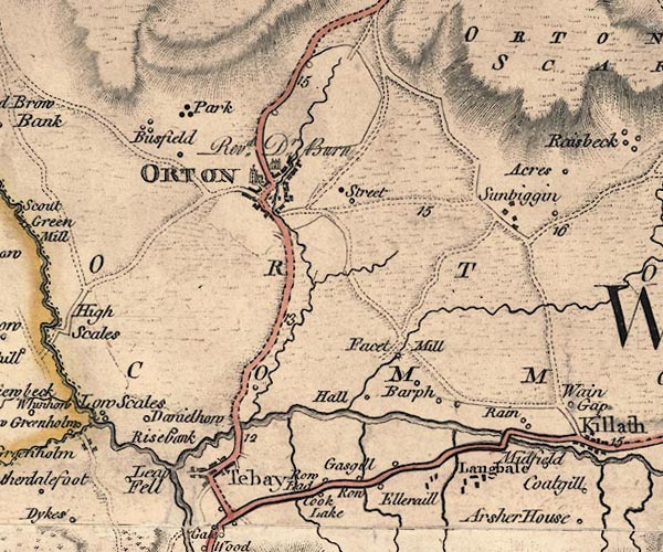 J5NY60NW.jpg 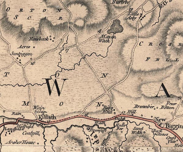 J5NY60NE.jpg 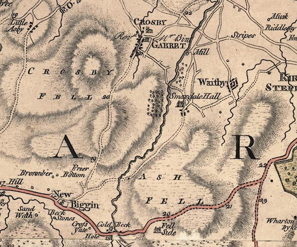 J5NY70NW.jpg 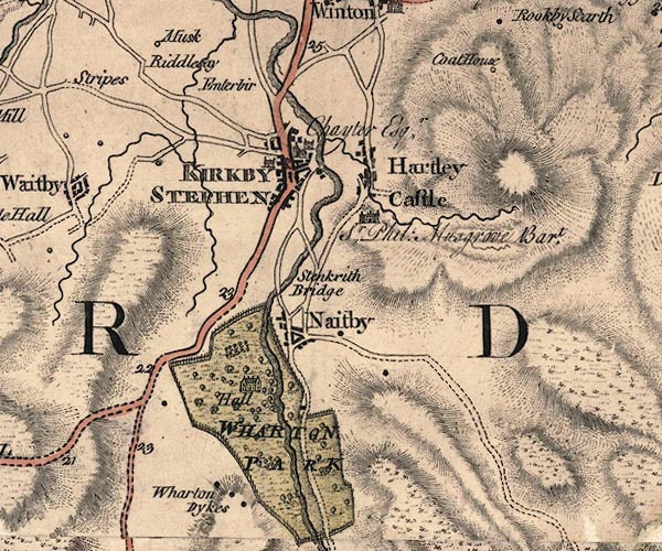 J5NY70NE.jpg double line; road, bold, main road, with mile numbers item:- National Library of Scotland : EME.s.47 Images © National Library of Scotland |
|||
|
|
||||
| evidence:- | old map:- Cary 1789 (edn 1805) |
|||
| source data:- | Map, uncoloured engraving, Westmoreland, scale about 2.5 miles
to 1 inch, by John Cary, London, 1789; edition 1805.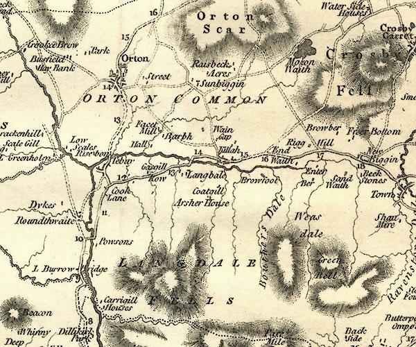 CY24NY60.jpg 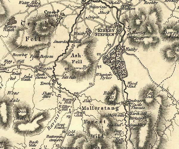 CY24NY70.jpg double line, bold light, numbered miles; main road item:- JandMN : 129 Image © see bottom of page |
|||
|
|
||||
| evidence:- | road map:- Cary 1790 (Wmd/edn 1792) |
|||
| source data:- | Road map, hand coloured engraving, Westmoreland, scale about
11.5 miles to 1 inch, by John Cary, 181 Strand, London, 1790,
edn 1792.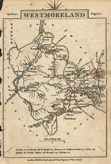 click to enlarge click to enlargeCY16.jpg double line, with road distances from Kendal item:- JandMN : 44 Image © see bottom of page |
|||
|
|
||||
| evidence:- | road book:- Cary 1798 (2nd edn 1802) |
|||
| source data:- | Road book, itineraries, Cary's New Itinerary, by John Cary, 181
Strand, London, 2nd edn 1802. goto source page 315-316 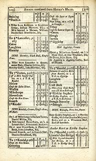 click to enlarge click to enlargeC38315.jpg "Near Tebay, on r. a T.R. to Brough." item:- JandMN : 228.1 Image © see bottom of page |
|||
|
|
||||
| evidence:- | old map:- Cooke 1802 |
|||
| source data:- | Map, Westmoreland ie Westmorland, scale about 12 miles to 1
inch, by George Cooke, 1802, published by Sherwood, Jones and
Co, Paternoster Road, London, 1824. click to enlarge click to enlargeGRA1Wd.jpg double line, light dark solid; road item:- Hampshire Museums : FA2000.62.4 Image © see bottom of page |
|||
|
|
||||
| evidence:- | old map:- Laurie and Whittle 1806 |
|||
| source data:- | Road map, Continuation of the Roads to Glasgow and Edinburgh,
scale about 10 miles to 1 inch, by Nathaniel Coltman? 1806,
published by Robert H Laurie, 53 Fleet Street, London, 1834. click to enlarge click to enlargeLw21.jpg dotted line with plus signs; 'Indifferent Cross Roads' item:- private collection : 18.21 Image © see bottom of page |
|||
|
|
||||
| evidence:- | old map:- Cooper 1808 |
|||
| source data:- | Map, hand coloured engraving, Westmoreland ie Westmorland, scale
about 9 miles to 1 inch, by H Cooper, 1808, published by R
Phillips, Bridge Street, Blackfriars, London, 1808. click to enlarge click to enlargeCOP4.jpg double line; road item:- Dove Cottage : 2007.38.53 Image © see bottom of page |
|||
|
|
||||
| evidence:- | old map:- Wallis 1810 (Wmd) |
|||
| source data:- | Road map, Westmoreland, scale about 19 miles to 1 inch, by James
Wallis, 77 Berwick Street, Soho, 1810, published by W Lewis,
Finch Lane, London, 1835? click to enlarge click to enlargeWAL5.jpg double line, light bold; 'Turnpike Road' item:- JandMN : 63 Image © see bottom of page |
|||
|
|
||||
| evidence:- | old map:- Hall 1820 (Wmd) |
|||
| source data:- | Map, hand coloured engraving, Westmoreland ie Westmorland, scale
about 14.5 miles to 1 inch, by Sidney Hall, London, 1820,
published by Samuel Leigh, 18 Strand, London, 1820-31. click to enlarge click to enlargeHA18.jpg single line, solid; minor road; Tebay, Killeth, Newbiggin, Kirkby Stephen item:- Armitt Library : 2008.14.58 Image © see bottom of page |
|||
|
|
||||
| evidence:- | old strip map:- CTC 1911 (Roads) |
|||
| source data:- | Page 98 of Cyclists' Touring Club British Road Book new series vol.6, edited by F
B Sandford, published by Thomas Nelson and Sons, London etc, 1911.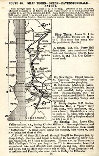 click to enlarge click to enlargeCTC298.jpg Strip road map, route 46, Shap Thorn Orton Ravenstonedale Nateby, scale roughly 5 miles to 1 inch. Together with an itinerary and gradient diagram. item:- JandMN : 491.98 Image © see bottom of page |
|||
|
|
||||
 Act of Parliament Act of Parliament |
||||
|
|
||||
| places:- | new route using old railway Tebay Newbiggin-on-Lune, Ravenstonedale Ravenstonedale close by Kirkby Stephen |
|||
|
|
||||
| places:- | old route Tebay Kelleth, Orton S Newbiggin-on-Lune, Ravenstonedale Ravenstonedale Kirkby Stephen |
|||
|
|
||||
| places:- |
|
|||
|
||||
|
||||
|
||||
Lakes Guides menu.