 Old Cumbria Gazetteer
 |
 |
|
||||||||||||||||||||||||||||||
| included in:- |
 road, Ambleside to Ravenglass road, Ambleside to Ravenglass |
|||||||||||||||||||||||||||||||
| road, Skelwith Bridge to Ravenglass | ||||||||||||||||||||||||||||||||
| Skelwith Bridge to Ravenglass | ||||||||||||||||||||||||||||||||
| Ravenglass to Skelwith Bridge | ||||||||||||||||||||||||||||||||
| civil parish:- | Skelwith (formerly Lancashire) | |||||||||||||||||||||||||||||||
| civil parish:- | Dunnerdale-with-Seathwaite (formerly Lancashire) | |||||||||||||||||||||||||||||||
| civil parish:- | Ulpha (formerly Cumberland) | |||||||||||||||||||||||||||||||
| civil parish:- | Eskdale (formerly Cumberland) | |||||||||||||||||||||||||||||||
| civil parish:- | Muncaster (formerly Cumberland) | |||||||||||||||||||||||||||||||
| county:- | Cumbria | |||||||||||||||||||||||||||||||
| locality type:- | route | |||||||||||||||||||||||||||||||
| 10Km square:- | NY30 | |||||||||||||||||||||||||||||||
| 10Km square:- | NY20 | |||||||||||||||||||||||||||||||
| 10Km square:- | NY10 | |||||||||||||||||||||||||||||||
| 10Km square:- | SD19 | |||||||||||||||||||||||||||||||
|
|
||||||||||||||||||||||||||||||||
| evidence:- | old map:- Jefferys 1770 (Wmd) |
|||||||||||||||||||||||||||||||
| source data:- | Map, 4 sheets, The County of Westmoreland, scale 1 inch to 1
mile, surveyed 1768, and engraved and published by Thomas
Jefferys, London, 1770.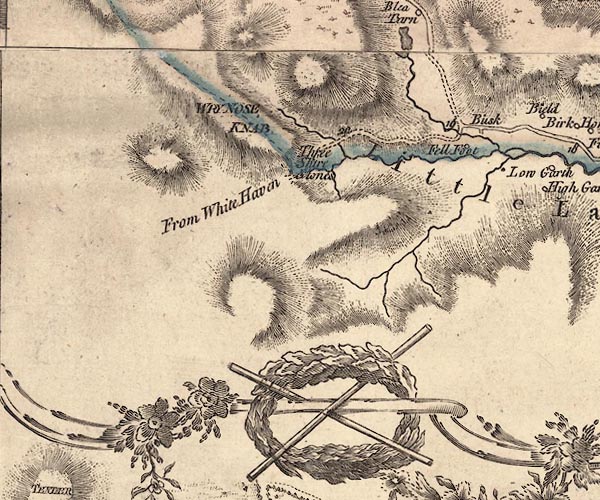 J5NY20SE.jpg "From White Haven" 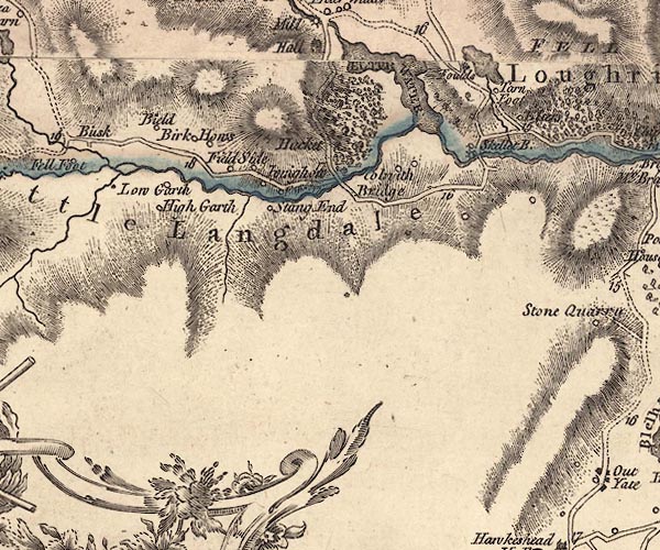 J5NY30SW.jpg 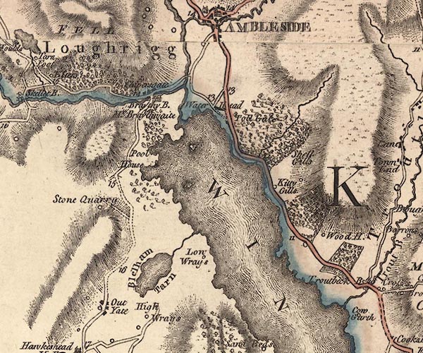 J5NY30SE.jpg double line; road, with mile numbers item:- National Library of Scotland : EME.s.47 Images © National Library of Scotland |
|||||||||||||||||||||||||||||||
|
|
||||||||||||||||||||||||||||||||
| evidence:- | old map:- Cary 1789 (edn 1805) |
|||||||||||||||||||||||||||||||
| source data:- | Map, uncoloured engraving, Westmoreland, scale about 2.5 miles
to 1 inch, by John Cary, London, 1789; edition 1805.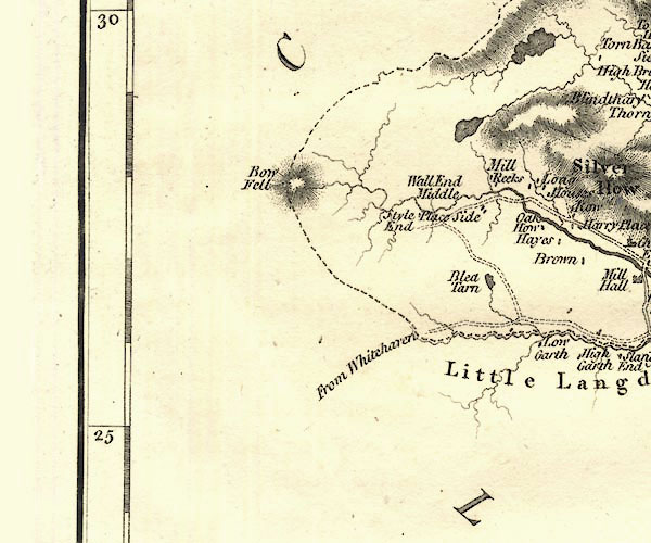 CY24NY20.jpg "from Whitehaven" road or track item:- JandMN : 129 Image © see bottom of page |
|||||||||||||||||||||||||||||||
|
|
||||||||||||||||||||||||||||||||
| evidence:- | old text:- Green 1814 |
|||||||||||||||||||||||||||||||
| source data:- | Set of prints, soft ground etchings, Sixty Small Prints, with
text, A Description of a Series of Sixty Small Prints, by
William Green, Ambleside, Westmorland, 1814. goto source page 23:- "..." "The head of the lake [Wast Water], in a straight line, is about fourteen miles north-west of Ambleside; but its approach from Ambleside ... is either difficult or circuitous." "The best pedestrian road from Ambleside to the foot of Wast Water is over Hardknott and Wrynose, and through the vale of Esk, by Santon Bridge to Nether Wasdale, which is about 22 miles; ..." "..." goto sourcepage 24:- "..." "The horse-road from Ambleside is over Hardknott and Wrynose to Santon Bridge, as before, ..." |
|||||||||||||||||||||||||||||||
|
|
||||||||||||||||||||||||||||||||
| evidence:- | descriptive text:- Otley 1823 (5th edn 1834) |
|||||||||||||||||||||||||||||||
| source data:- | Guide book, A Concise Description of the English Lakes, the
mountains in their vicinity, and the roads by which they may be
visited, with remarks on the mineralogy and geology of the
district, by Jonathan Otley, published by the author, Keswick,
Cumberland now Cumbria, by J Richardson, London, and by Arthur
Foster, Kirkby Lonsdale, Cumbria, 1823; published 1823-49,
latterly as the Descriptive Guide to the English Lakes. goto source "... The road ... After passing Little Langdale Tarn, the ancient pack horse road, from Kendal to Whitehaven over Wrynose, takes the left hand; ..." "..." goto sourcePage 107:- "AMBLESIDE TO ESKDALE AND WASDALE." "This tour may be made on horseback, or with some little difficulty in a cart; taking the road to Little Langdale as before described, and following the old pack-horse road over Wrynose and Hardknot, both of which hills are very steep. Near the road on Wrynose are the three shire stones of Cumberland, Westmorland, and Lancashire. From Westmorland we here pass into Lancashire; and crossing the head of the Duddon at Cockley-beck, we enter into Cumberland. From the top of" goto sourcePage 108:- "Hardknot there is a view of the sea, and the Isle of Man in the horizon; and half way down the hill on the right, are the ruins of a place called Hardknot Castle, described in a former page; but having been built without mortar, or cement, scarcely any part of the walls are left standing." "The small river Esk winds along a narrow valley, among verdant fields, surmounted by rugged rocks, and about a mile and a half down the valley is a public-house, formerly the sign of the Wool Pack, about 15 miles from Ambleside. On the left hand, in travelling down the valley, there are two remarkable cascades. The first is seen from the road; but the other, which lies beyond the chapel, requires a walk of more than half a mile to view it. From the hamlet of Bout, a dim tract leads over Burnmoor to Wasdale head; but the road should be kept, nearly to Santon Bridge, when it turns off to the right, to the Strands at Nether Wasdale; where there are two public-houses. After seeing Wast Water, parties on horseback may either go over Styhead and through Borrowdale to Keswick; or by Gosforth to Calder Bridge, from thence by Ennerdale Bridge, and Lamplugh, to Scale Hill, and thence by either Buttermere or Lorton, to Keswick; and with a cart it will be necessary to take the latter route. Sometimes this excursion has been varied, by returning from Wasdale, by Ulpha, to Broughton, and thence by Coniston to Ambleside."
|
|||||||||||||||||||||||||||||||
|
|
||||||||||||||||||||||||||||||||
| evidence:- | descriptive text:- Ford 1839 (3rd edn 1843) placename:- Old Bell Road |
|||||||||||||||||||||||||||||||
| source data:- | Guide book, A Description of Scenery in the Lake District, by
Rev William Ford, published by Charles Thurnam, Carlisle, by W
Edwards, 12 Ave Maria Lane, Charles Tilt, Fleet Street, William
Smith, 113 Fleet Street, London, by Currie and Bowman,
Newcastle, by Bancks and Co, Manchester, by Oliver and Boyd,
Edinburgh, and by Sinclair, Dumfries, 1839. goto source Page 37:- "..." "... Further on to the left is Fell Foot, an ancient inn, on the Old Bell road which led from Kendal to Whitehaven over Hard Knot and Wry Nose." |
|||||||||||||||||||||||||||||||
|
|
||||||||||||||||||||||||||||||||
| evidence:- | old text:- Martineau 1855 item:- packhorse |
|||||||||||||||||||||||||||||||
| source data:- | Guide book, A Complete Guide to the English Lakes, by Harriet
Martineau, published by John Garnett, Windermere, Westmorland,
and by Whittaker and Co, London, 1855; published 1855-76. goto source Page 115:- "... to Fellfoot, and the old road from Kendal to Whitehaven, which was the only route before carriers' carts found their way into the region. Fellfoot was the house of entertainment whence the pack-horse cavalcade began the ascent, or where they stopped to congratulate themselves on having accomplished the descent. ... ... The ascent of Wrynose from this point is long and rather steep: but the views behind become grander with every step. ..." |
|||||||||||||||||||||||||||||||
|
|
||||||||||||||||||||||||||||||||
| evidence:- | old strip map:- Rumney 1899 |
|||||||||||||||||||||||||||||||
| source data:- | Road map, strip map and itinerary for Route XIX, Seascale to Eskdale, Cumberland,
scale about 2 miles to 1 inch, by A W Rumney, published by George Philip and Son,
32 Fleet Street, London, and Liverpool, 1899.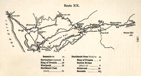 click to enlarge click to enlargeRUM130.jpg On p.80 of the Cyclist's Guide to the English Lake District, by A W Rumney. printed at top:- "Route XIX." item:- JandMN : 147.31 Image © see bottom of page |
|||||||||||||||||||||||||||||||
|
|
||||||||||||||||||||||||||||||||
| places:- | [Skelwith Bridge] Little Langdale, Lakes [Fell Foot, Lakes] Wrynose Pass, Ulpha Cockley Beck, Dunnerdale-with-Seathwaite Hardknott Pass, Eskdale Eskdale Green, Eskdale Ravenglass |
|||||||||||||||||||||||||||||||
|
|
||||||||||||||||||||||||||||||||
Lakes Guides menu.