 West 1784 map

|

|
|
|
item:- Armitt Library : A1221.1 image:- © see bottom of page |
click to enlarge | |
| Map of the Lakes. | ||

|
menu with map squares and placename index | |
|
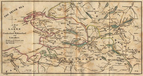
Map, hand coloured engraving, A Map of the Lakes in
Cumberland, Westmorland and Lancashire, scale about 3.5
miles to 1 inch, engraved by Paas, 53 Holborn, London, about
1784.
Inserted in Thomas West's Guide to the Lakes, 11th edition, 1821. |
||
|
|
West 1784 map | |
| map feature:- | north point & up is W & scale line & sea plain & coast form lines & rivers & relief & hill hachuring & parks & county & settlements & roads & canals | |
| inscription:- |
printed middle left
A MAP / of the / LAKES / in / Cumberland, Westmorland / and / Lancashire. |
|
| inscription:- |
printed bottom left and right
Paas sculp. / No.53 Holborn |
|
| scale line:- | 5 miles = 34.8 mm | |
| wxh, sheet:- | 38.5x21.5cm (approx) | |
| wxh, map:- | 372x191mm (approx) | |
| scale:- | 1 to 230000 ? (from scale line) | |
|
|
notes | |