 Otley 1818

|

|
|
|
item:- Armitt Library : A1170.1 image:- © see bottom of page |
click to enlarge |
|
|
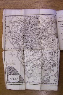
Map, uncoloured engraving, The District of the Lakes,
Cumberland, Westmorland, and Lancashire, scale about 4 miles
to 1 inch, by Jonathan Otley, 1818, engraved by J and G
Menzies, Edinburgh, Scotland, published by Jonathan Otley,
Keswick, Cumberland, 1823.
Tipped in as frontispiece to A Concise Description of the English Lakes, by Jonathan Otley, 1st edn 1823. |
||

|
Otley 1818 | |
| map feature:- | folded & plain cartouche & north point & magnetic deviation (26d W) & scale line & lat and long scales & sea plain & coast shaded & rivers & lakes & relief & hill hachuring & table of heights & settlements & roads & canals | |
| inscription:- |
printed title cartouche, lower left
The District / of the / LAKES / By J. Otley / KESWICK 1818. |
|
| inscription:- |
printed bottom left and right
2d. Edit. 1823 / Engraved by J. & G. Menzies, Edinr. |
|
| inscription:- |
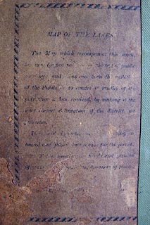
printed back cover of guide book
MAP OF THE LAKES. / The map which accompanies this work, / [has now ] for five ye[ ]he [test of] public / [ ]ng and [h]as ever b[ ]en th[ ] / of the Publis[her] to render [ ] worthy of the / [patrona]ge it has received, by making it the / mo[st ]orrect delineationn of the district [ ] / [Published.] / It [ co] / loured and fol[ded into] a case for the poc[k]et. / [ ] T[ ] she[w ] and [p]o[sitio]n / [of ] of pla[ces]. / [ ] |
|
| scale line:- | 10 miles = 61.7 mm | |
| wxh, map:- | 252x315mm | |
| scale:- | 1 to 260000 ? (1 to 260834 from scale line) | |
|
||