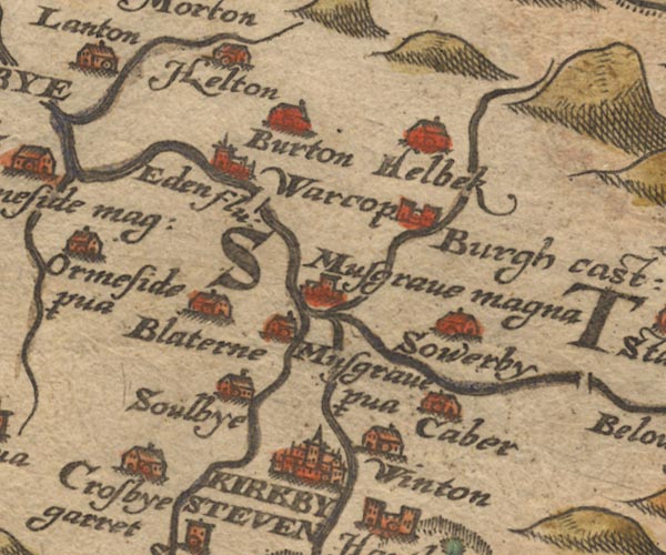
 Saxton 1576 NY71


|

|
|
|
gazetteer links places may or may not be labelled on the map |
||

|
-- Belah, River -- "Below flu:" |
|
|
|
-- Bleatarn -- "Blaterne" |
|
|
|
-- Brough Castle -- "Burgh cast:" |
|
|
|
-- Brough Sowerby -- "Sowerby" |
|
|
|
-- Burton -- "Burton" |
|
|
|
-- Crosby Garrett -- "Crosbye garret" |
|
|
|
-- Eden, River -- "Eden flu:" -- "Eden flu:"
-- "Eden flu:" -- "Eden flu:" |
|
|
|
-- Great Musgrave -- "Musgrave magna" |
|
|
|
-- Helbeck -- "Helbek" |
|
|
|
-- Hilton -- "Helton" |
|
|
|
-- Kaber -- "Caber" |
|
|
|
-- Kirkby Stephen -- "KIRKBY STEVEN" |
|
|
|
-- Little Musgrave -- "Musgrave p~va" |
|
|
|
-- Scandal Beck |
|
|
|
-- Soulby -- "Soulbye" |
|
|
|
-- Swindale Beck |
|
|
|
-- Warcop -- "Warcop" |
|
|
|
-- Winton -- "Winton" |
|
|
civil parishes The area roughly includes parts of parishes:- Brough Sowerby Asby Ormside Stainmore Winton Musgrave Warcop Soulby Kaber Crosby Garrett Murton Helbeck Hartley Kirkby Stephen Brough |
||
|
|
||
|
|
Lakes Guides menu. | |