 Old Cumbria Gazetteer
 |
 |
|
|
| Maryport and Carlisle Railway | |||
| MandCR | |||
| Cumbrian Coast Line | |||
| civil parish:- | Maryport (formerly Cumberland) | ||
| civil parish:- | Dearham (formerly Cumberland) | ||
| civil parish:- | Crosscanonby (formerly Cumberland) | ||
| civil parish:- | Gilcrux (formerly Cumberland) | ||
| civil parish:- | Oughterside and Allerby (formerly Cumberland) | ||
| civil parish:- | Plumbland (formerly Cumberland) | ||
| civil parish:- | Aspatria (formerly Cumberland) | ||
| civil parish:- | Bromfield (formerly Cumberland) | ||
| civil parish:- | Waverton (formerly Cumberland) | ||
| civil parish:- | Woodside (formerly Cumberland) | ||
| civil parish:- | Wigton (formerly Cumberland) | ||
| civil parish:- | Westward (formerly Cumberland) | ||
| civil parish:- | Dalston (formerly Cumberland) | ||
| civil parish:- | Cummersdale (formerly Cumberland) | ||
| civil parish:- | St Cuthbert Without (formerly Cumberland) | ||
| civil parish:- | Carlisle (formerly Cumberland) | ||
| county:- | Cumbria | ||
| locality type:- | railway | ||
| civil parish:- | Aspatria (formerly Cumberland) | ||
| civil parish:- | Allhallows (formerly Cumberland) | ||
| civil parish:- | Boltons (formerly Cumberland) | ||
| civil parish:- | Waverton (formerly Cumberland) | ||
| county:- | Cumbria | ||
| locality type:- | railway | ||
| SummaryText:- | from Maryport, through Dearham Bridge, Bull Gill, Aspatria, then either Brayton, Leegate or Baggrow, Mealsgate, High Blaithwaite, then Wigton, Curthwaite, Dalston, Cummersdale, to Carlisle, Cumberland; AND extansion from Bull Gill, through Dearham, Papcastle, to the Cockermouth and Workington Railway, Cumberland. | ||
| references:- | 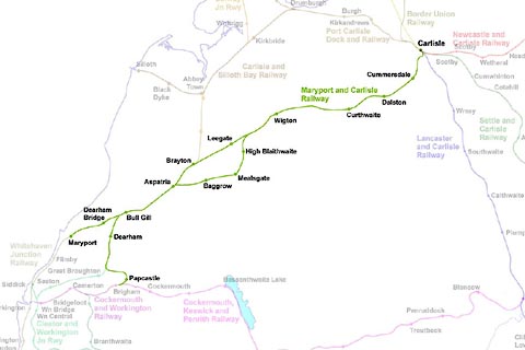 click to enlarge click to enlargeRWY019.jpg |
||
|
|
|||
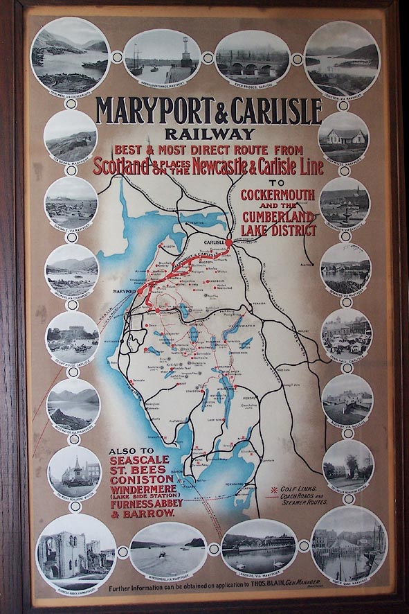 click to enlarge click to enlargeBNS38.jpg Poster (in the Maritime Museum, Maryport) (taken 25.5.2007) 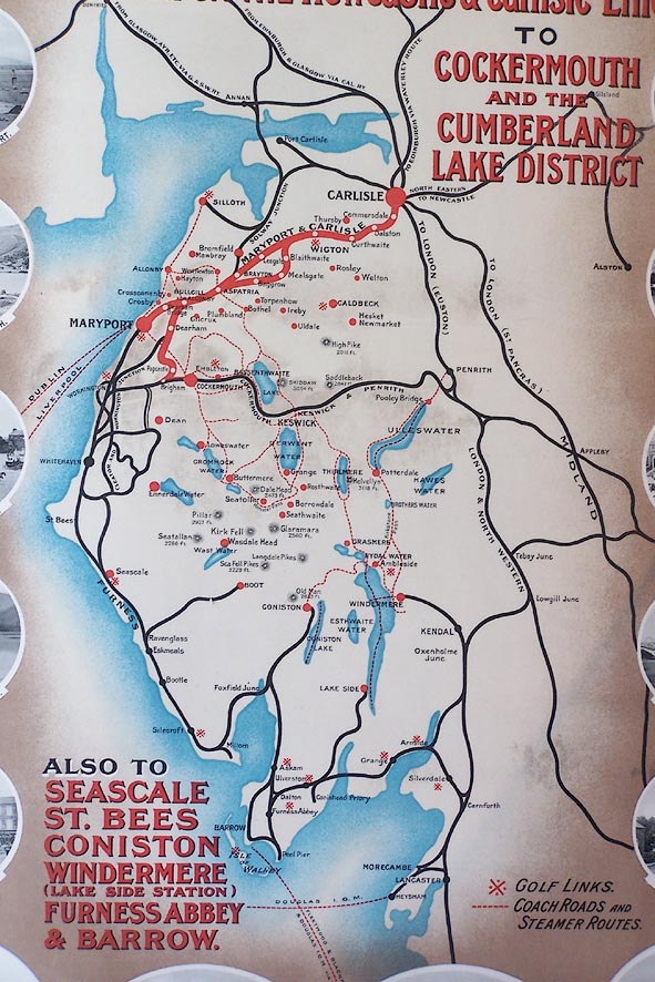 click to enlarge click to enlargeBNS39.jpg Poster (in the Maritime Museum, Maryport) (taken 25.5.2007) |
|||
|
|
|||
| evidence:- | old map:- Ford 1839 map placename:- Maryport and Carlisle Railway |
||
| source data:- | Map, uncoloured engraving, Map of the Lake District of
Cumberland, Westmoreland and Lancashire, scale about 3.5 miles
to 1 inch, published by Charles Thurnam, Carlisle, and by R
Groombridge, 5 Paternoster Row, London, 3rd edn 1843.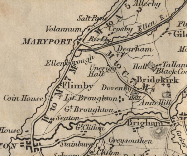 FD02NY03.jpg 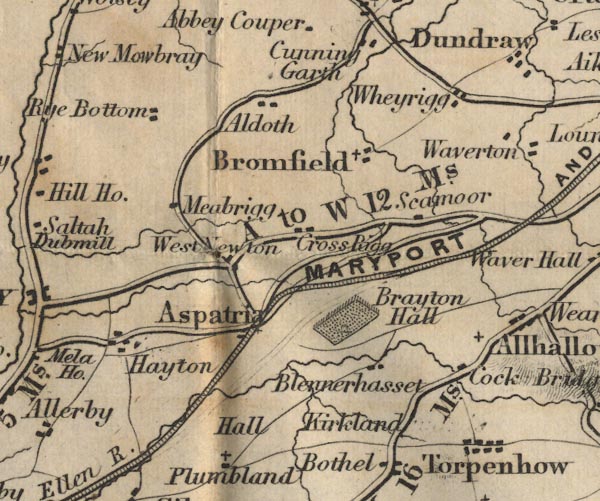 FD02NY14.jpg "MARYPORT AND CARLISLE RAILWAY" 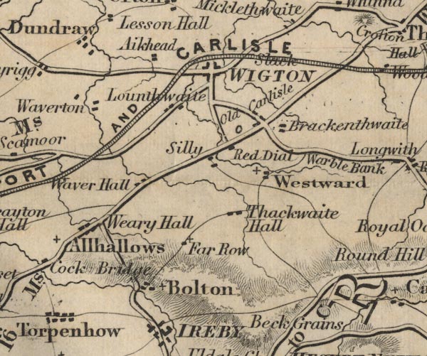 FD02NY24.jpg 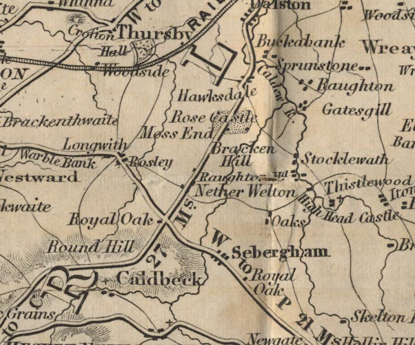 FD02NY34.jpg 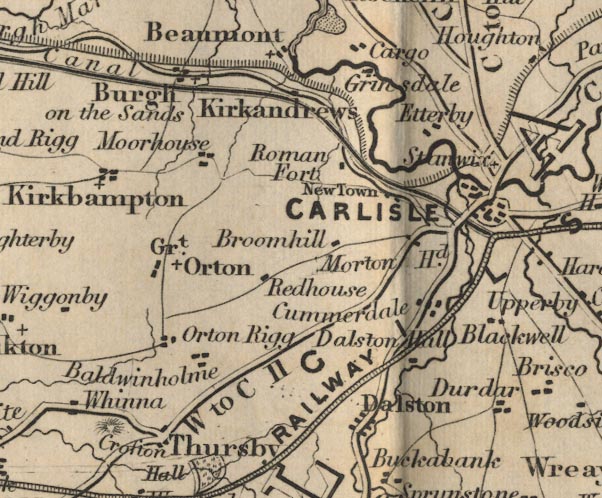 FD02NY35.jpg item:- JandMN : 100.1 Image © see bottom of page |
||
|
|
|||
| evidence:- | old map:- Garnett 1850s-60s H placename:- Whitehaven Maryport and Carlisle Railway |
||
| source data:- | Map of the English Lakes, in Cumberland, Westmorland and
Lancashire, scale about 3.5 miles to 1 inch, published by John
Garnett, Windermere, Westmorland, 1850s-60s.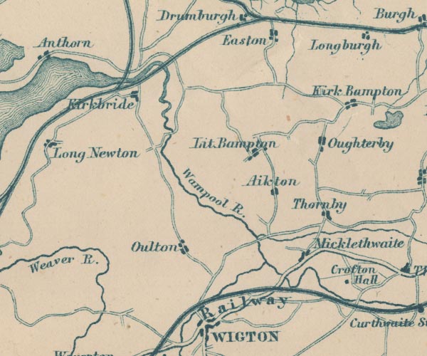 GAR2NY25.jpg triple line, light bold light, railway 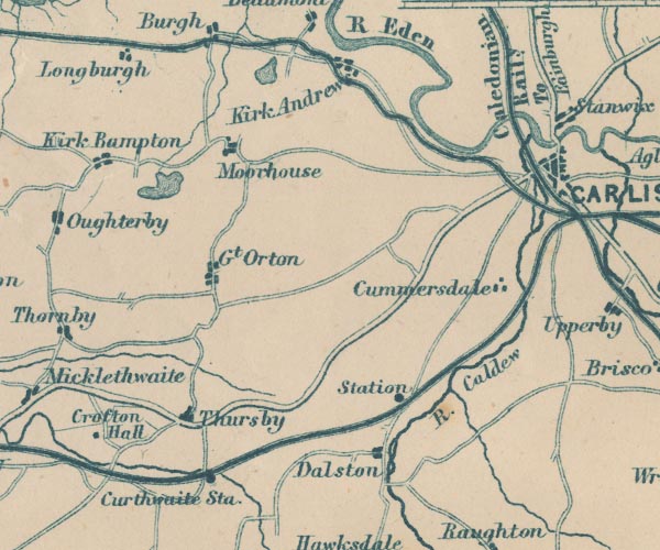 GAR2NY35.jpg 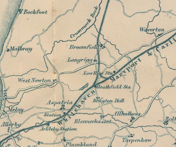 GAR2NY14.jpg "Whitehaven Maryport &Carlisle Railway" 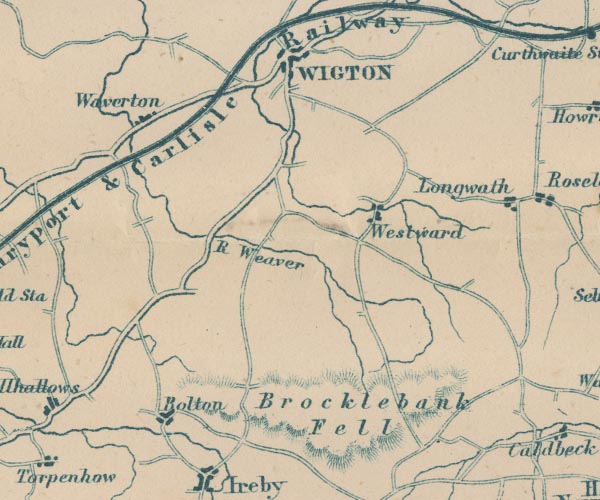 GAR2NY24.jpg 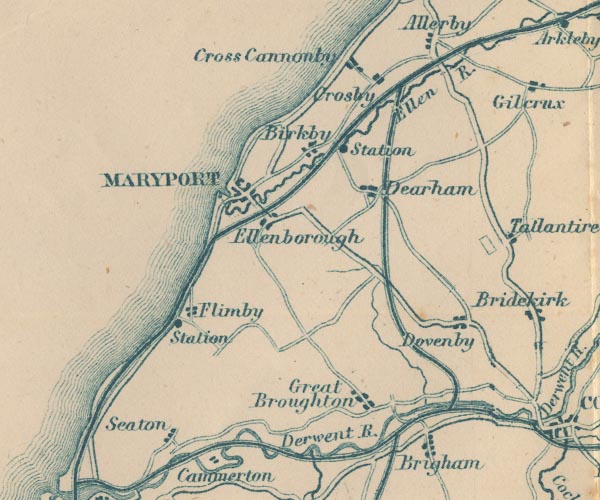 GAR2NY03.jpg item:- JandMN : 82.1 Image © see bottom of page |
||
|
|
|||
 Derwent branch railway from 1865 Derwent branch railway from 1865 |
|||
|
|
|||
| evidence:- | old map:- LMS 1939 B |
||
| source data:- |  click to enlarge click to enlargeLMS6Cm.jpg "MAP OF LMS RAILWAY" item:- JandMN : 1016.5 Image © see bottom of page |
||
|
|
|||
| hearsay:- |
28 mile line. |
||
| The route was from Maryport, to Carlisle, Cumbria. |
|||
|
|
|||
| person:- | railway company : Maryport and Carlisle Railway |
||
| date:- | 1837 to 1923 |
||
|
|
|||
| person:- | railway company : London, Midland and Scottish Railway; LMS |
||
| date:- | 1923 to 1948 |
||
|
|
|||
| person:- | railway company : British Railways; BR |
||
| date:- | 1948 |
||
|
|
|||
| branch:- |  Derwent branch railway Derwent branch railway |
||
|
|
|||
| goes through:- | Maryport Harbour, Maryport Maryport Station, Maryport (2) Maryport Station, Maryport railway bridge, Crosscanonby Dearham Bridge Station, Crosscanonby Bullgill Junction, Gilcrux railway milepost, Bullgill railway bridge, Bullgill Bullgill Station, Bullgill railway bridge, Bullgill (2) railway bridge, Ellenhall railway bridge, Ellen Villa railway bridge, Ellen Villa (2) railway sidings, Arkleby railway bridge, Aspatria (4) Aspatria Station, Aspatria [Aspatria Junction, Aspatria] [railway bridge, Aspatria (3)] [railway bridge, Aspatria (2)] railway bridge, Aspatria Aspatria Tunnel, Aspatria Brayton Station, Brayton Brayton Junction, Brayton Low Row Station, Bromfield Leegate Station, Bromfield railway bridge, Waverton Aikbank Junction, Waverton railway bridge, Blaithwaite railway bridge, Waverton (2) Brookfield Station, Wigton Wigton Station, Wigton railway bridge, Wigton Micklethwaite Station, Woodside Crofton Station, Westward railway bridge, Westward Curthwaite Station, Westward Dalston Station, Dalston railway bridge, Dalston Cummersdale Station, Cummersdale Caldew railway bridge, Cummersdale railway junction, Carlisle railway footbridge, Carlisle South End Co-op Junction, Carlisle Maryport and Carlisle Goods Depot, Carlisle MandC and LandC Junction, Carlisle12.7.1837: authorized - 1840: opened, Maryport to Arkleby - 1841: opened, Maryport to Aspatria - 1843: opened, Carlisle to Wigton - 1844: opened, Wigton to Aspatria - 1845: opened - |
||
|
|
|||
| mapping:- | Maryport Station, Maryport (2) |
||
|
|
|||
| goes through:- | [Aspatria Junction, Aspatria] [railway bridge, Allhallows] [Baggrow Station, Allhallows] [Mealsgate Station, Boltons] High Blaithwaite Station, Boltons Aikbank Junction, Waverton |
||
|
|
|||
Lakes Guides menu.