 Old Cumbria Gazetteer
 |
 |
|
| Armathwaite Castle, Armathwaite | ||
| Armathwaite Castle | ||
| locality:- | Armathwaite | |
| civil parish:- | Hesket (formerly Cumberland) | |
| county:- | Cumbria | |
| locality type:- | buildings | |
| locality type:- | pele tower | |
| locality type:- | castle (once) | |
| coordinates:- | NY50564586 | |
| 1Km square:- | NY5045 | |
| 10Km square:- | NY54 | |
|
|
||
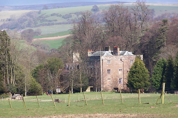 BNI30.jpg (taken 9.3.2007) 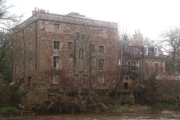 CEU66.jpg (taken 8.4.2016) |
||
|
|
||
| evidence:- | old map:- OS County Series (Cmd 31) placename:- Armathwaite Castle |
|
| source data:- | Maps, County Series maps of Great Britain, scales 6 and 25
inches to 1 mile, published by the Ordnance Survey, Southampton,
Hampshire, from about 1863 to 1948. |
|
|
|
||
| evidence:- | old map:- Saxton 1579 placename:- Armathwate Castle |
|
| source data:- | Map, hand coloured engraving, Westmorlandiae et Cumberlandiae Comitatus ie Westmorland
and Cumberland, scale about 5 miles to 1 inch, by Christopher Saxton, London, engraved
by Augustinus Ryther, 1576, published 1579-1645.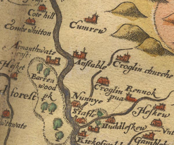 Sax9NY54.jpg Building with two towers, symbol for a castle. "Armathwate cast:" item:- private collection : 2 Image © see bottom of page |
|
|
|
||
| evidence:- | old map:- Mercator 1595 (edn?) placename:- Armanthwate Castle |
|
| source data:- | Map, hand coloured engraving, Northumbria, Cumberlandia, et
Dunelmensis Episcopatus, ie Northumberland, Cumberland and
Durham etc, scale about 6.5 miles to 1 inch, by Gerard Mercator,
Duisberg, Germany, about 1595.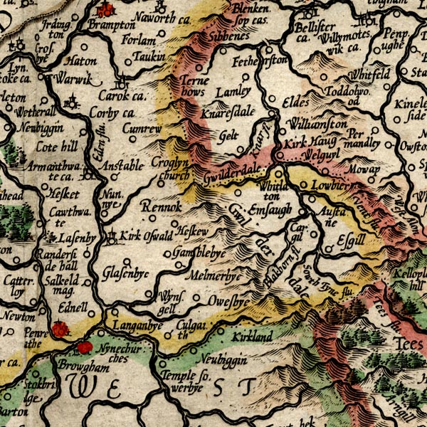 MER8CumD.jpg "Armanthwate ca." circle, building and tower item:- JandMN : 169 Image © see bottom of page |
|
|
|
||
| evidence:- | old map:- Speed 1611 (Cmd) placename:- Armanthwat Castle |
|
| source data:- | Map, hand coloured engraving, Cumberland and the Ancient Citie
Carlile Described, scale about 4 miles to 1 inch, by John Speed,
1610, published by J Sudbury and George Humble, Popes Head
Alley, London, 1611-12.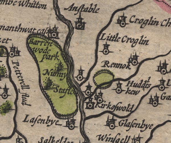 SP11NY54.jpg "Armanthwat cas." circle, buildings, tower item:- private collection : 16 Image © see bottom of page |
|
|
|
||
| evidence:- | probably table of distances:- Simons 1635 placename:- Armanthwait Castle |
|
| source data:- | Table of distances, uncoloured engraving, Cumberland, with a
thumbnail map, scale about 41 miles to 1 inch, by Mathew Simons,
published in A Direction for the English Traviller, 1635.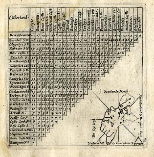 click to enlarge click to enlargeSIM4.jpg "Arma~thwait Ca: SE." and tabulated distances; A on thumbnail map? item:- private collection : 50.11 Image © see bottom of page |
|
|
|
||
| evidence:- | old map:- Jansson 1646 placename:- Armanth Watcast placename:- Armanthwaite Castle |
|
| source data:- | Map, hand coloured engraving, Cumbria and Westmoria, ie
Cumberland and Westmorland, scale about 3.5 miles to 1 inch, by
John Jansson, Amsterdam, Netherlands, 1646.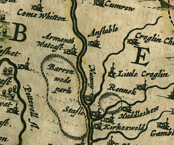 JAN3NY54.jpg "Armanth Watcast" Buildings and tower, no flag. item:- JandMN : 88 Image © see bottom of page |
|
|
|
||
| evidence:- | old map:- Morden 1695 (Cmd) placename:- Armanthwate Castle |
|
| source data:- | Map, uncoloured engraving, Cumberland, scale about 4 miles to 1
inch, by Robert Morden, 1695, published by Abel Swale, the
Unicorn, St Paul's Churchyard, Awnsham, and John Churchill, the
Black Swan, Paternoster Row, London, 1695-1715.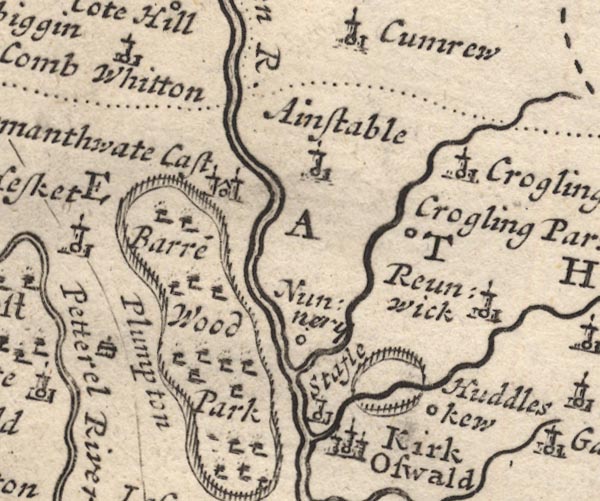 MD12NY54.jpg "Armanthwate Cast" Circle, building with two towers. item:- JandMN : 90 Image © see bottom of page |
|
|
|
||
| evidence:- | descriptive text:- Simpson 1746 placename:- Armathwaite Castle placename:- Armathwaite |
|
| source data:- | Atlas, three volumes of maps and descriptive text published as
'The Agreeable Historian, or the Compleat English Traveller
...', by Samuel Simpson, 1746. goto source goto source"Armathwaite-Castle, belonging to the Skeltons, ..." goto source"... Armathwaite, the Seat of John Skelton, Esq; ..." |
|
|
|
||
| evidence:- | old map:- Bowen and Kitchin 1760 placename:- Armanthwayte Castle |
|
| source data:- | Map, hand coloured engraving, A New Map of the Counties of
Cumberland and Westmoreland Divided into their Respective Wards,
scale about 4 miles to 1 inch, by Emanuel Bowen and Thomas
Kitchin et al, published by T Bowles, Robert Sayer, and John
Bowles, London, 1760.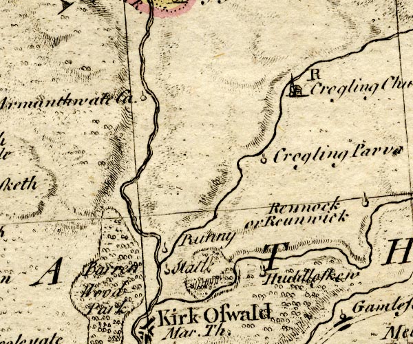 BO18NY54.jpg "Armanthwayte Ca." circle and line item:- Armitt Library : 2008.14.10 Image © see bottom of page |
|
|
|
||
| evidence:- | old map:- Donald 1774 (Cmd) |
|
| source data:- | Map, hand coloured engraving, 3x2 sheets, The County of Cumberland, scale about 1
inch to 1 mile, by Thomas Donald, engraved and published by Joseph Hodskinson, 29
Arundel Street, Strand, London, 1774. D4NY54NW.jpg "Castle / Milbourne Esq." large building; a castle at Armathwaite item:- Carlisle Library : Map 2 Image © Carlisle Library |
|
|
|
||
| evidence:- | old text:- Clarke 1787 placename:- Armathwaite Castle |
|
| source data:- | Guide book, A Survey of the Lakes of Cumberland, Westmorland,
and Lancashire, written and published by James Clarke, Penrith,
Cumberland, and in London etc, 1787; published 1787-93. goto source Page 105:- "..." "I do not find any ancient authors mention a castle here [Castlerigg], Speed, who speaks of twenty-five in Cumberland, hath found out every one I ever heard or knew of, except Kirkoswald; how that has escaped him I cannot tell. I shall here put down their names, and, as well as I can, their most ancient owners, and supposed founders." "..." goto sourcePage 106:- "..." "11 ARMATHWAITE. Some say William Rufus, only because he built and endowed an Abbey near it; others the Romans, now William Millbourn's, Esquire." "..." |
|
|
|
||
| evidence:- | old text:- Camden 1789 placename:- Armanthwayte Castle |
|
| source data:- | Book, Britannia, or A Chorographical Description of the Flourishing Kingdoms of England,
Scotland, and Ireland, by William Camden, 1586, translated from the 1607 Latin edition
by Richard Gough, published London, 1789. goto source Page 174:- "..." "... Armanthwayte, a castle of the Skeltons ..." |
|
|
|
||
| evidence:- | old text:- Camden 1789 (Gough Additions) placename:- Armathwaite Castle item:- sword |
|
| source data:- | Book, Britannia, or A Chorographical Description of the Flourishing Kingdoms of England,
Scotland, and Ireland, by William Camden, 1586, translated from the 1607 Latin edition
by Richard Gough, published London, 1789. goto source Page 191:- "..." "Armathwaite castle belongs to William Milborne, esq., by inheritance of Robert Sanderson, who bought it of Richard Shelton, esq., 1712, whose grandfather rebuilt and endowed the chapel here. In the castle was preserved in Mr. Machel's time a broad sword with a basket hilt; on one side of the blade EDWARDUS, on the other PRINS ANGLIE. It was probably left there in Edward I's time, and the prince might lodge here when his father's headquarters were at Lanercost. ..." |
|
|
|
||
| evidence:- | road book:- Cary 1798 (2nd edn 1802) placename:- Armathwaite Castle |
|
| source data:- | Road book, itineraries, Cary's New Itinerary, by John Cary, 181
Strand, London, 2nd edn 1802. goto source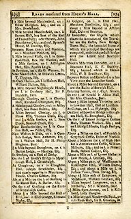 click to enlarge click to enlargeC38273.jpg page 273-274 "About 2 Miles on the r. of High Hesket is Armathwaite Castle, William Milburn, Esq. ..." goto source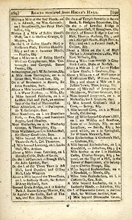 click to enlarge click to enlargeC38289.jpg page 289-290 "About 2 Miles on the r. of High Hesket is Armathwaite Castle, William Milburn, Esq." item:- JandMN : 228.1 Image © see bottom of page |
|
|
|
||
| evidence:- | descriptive text:- Ford 1839 (3rd edn 1843) placename:- Armathwaite Castle |
|
| source data:- | Guide book, A Description of Scenery in the Lake District, by
Rev William Ford, published by Charles Thurnam, Carlisle, by W
Edwards, 12 Ave Maria Lane, Charles Tilt, Fleet Street, William
Smith, 113 Fleet Street, London, by Currie and Bowman,
Newcastle, by Bancks and Co, Manchester, by Oliver and Boyd,
Edinburgh, and by Sinclair, Dumfries, 1839. goto source Page 125:- "..." "... [Armathwaite] Castle is a plain square tower, standing on the river's bank, fitted up so as to meet the wants and comforts of modern refinement. The chapel of ease is a rude picturesque edifice, in the patronage of the owners of the Castle, ..." |
|
|
|
||
| evidence:- | database:- Listed Buildings 2010 placename:- Armathwaite Castle |
|
| source data:- | courtesy of English Heritage "ARMATHWAITE CASTLE / / / HESKET / EDEN / CUMBRIA / II[star] / 73864 / NY5057245873" |
|
|
|
||
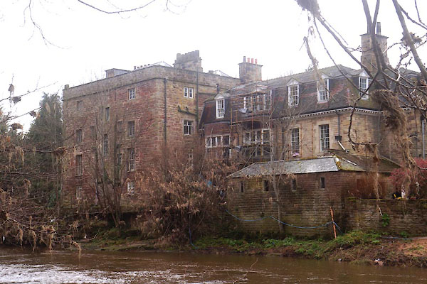 CEU65.jpg (taken 8.4.2016) |
||
|
|
||
| hearsay:- |
Four storey pele tower with 18th century, georgian, additions. Owned by the Skelton
Family up to 1712. About the time of Edward II to Henry VIII, the Skeltons represented
the county of Cumberland in Parliament. John Skelton was poet laureate to Henry VIII. |
|
| Closed to visits. |
||
|
|
||
| notes:- |
15th century tower |
|
| Perriam, D R &Robinson, J: 1998: Medieval Fortified Buildings of Cumbria: CWAAS::
ISBN 1 873124 23 6; plan and elevation |
||
|
|
||
| hearsay:- |
This is said to be where King Arthur slew the Giant of Castle Ewain. |
|
|
|
||
Lakes Guides menu.