 Old Cumbria Gazetteer
 |
 |
|
||||||||||||||||||||||||
| Bassenthwaite Lake | ||||||||||||||||||||||||||
| site name:- | Derwent, River | |||||||||||||||||||||||||
| civil parish:- | Bassenthwaite (formerly Cumberland) | |||||||||||||||||||||||||
| civil parish:- | Setmurthy (formerly Cumberland) | |||||||||||||||||||||||||
| civil parish:- | Above Derwent (formerly Cumberland) | |||||||||||||||||||||||||
| civil parish:- | Wythop (formerly Cumberland) | |||||||||||||||||||||||||
| civil parish:- | Underskiddaw (formerly Cumberland) | |||||||||||||||||||||||||
| county:- | Cumbria | |||||||||||||||||||||||||
| locality type:- | lake | |||||||||||||||||||||||||
| coordinates:- | NY21432975 (etc) | |||||||||||||||||||||||||
| 1Km square:- | NY2129 | |||||||||||||||||||||||||
| 10Km square:- | NY22 | |||||||||||||||||||||||||
|
|
||||||||||||||||||||||||||
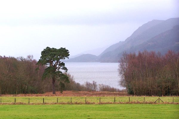 BLO53.jpg From Armathwaite Hall, on a dull day. (taken 20.1.2006) 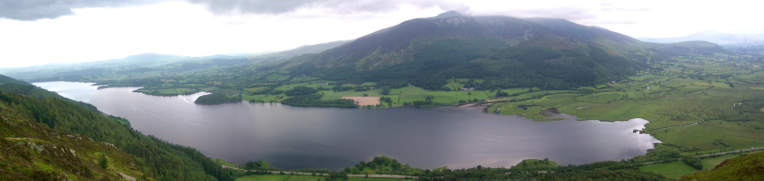 Click to enlarge BWT30.jpg From Barf. (taken 13.6.2012) |
||||||||||||||||||||||||||
|
|
||||||||||||||||||||||||||
| evidence:- | old map:- OS County Series (Cmd 55 3) placename:- Bassenthwaite Lake |
|||||||||||||||||||||||||
| source data:- | Maps, County Series maps of Great Britain, scales 6 and 25
inches to 1 mile, published by the Ordnance Survey, Southampton,
Hampshire, from about 1863 to 1948. OS County Series (Cmd 55 4) OS County Series (Cmd 55 8) |
|||||||||||||||||||||||||
|
|
||||||||||||||||||||||||||
| evidence:- | old map:- OS County Series (Cmd 55) |
|||||||||||||||||||||||||
| source data:- | Maps, County Series maps of Great Britain, scales 6 and 25
inches to 1 mile, published by the Ordnance Survey, Southampton,
Hampshire, from about 1863 to 1948. "Lowest point of bed of lake 153 Feet above O.S. datum" elsewhere:- "Sur. of Water 223 0" |
|||||||||||||||||||||||||
|
|
||||||||||||||||||||||||||
| evidence:- | old map:- Saxton 1579 |
|||||||||||||||||||||||||
| source data:- | Map, hand coloured engraving, Westmorlandiae et Cumberlandiae Comitatus ie Westmorland
and Cumberland, scale about 5 miles to 1 inch, by Christopher Saxton, London, engraved
by Augustinus Ryther, 1576, published 1579-1645.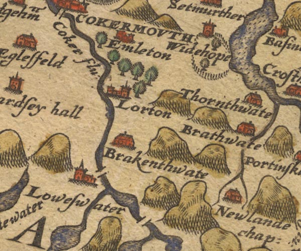 Sax9NY12.jpg item:- private collection : 2 Image © see bottom of page |
|||||||||||||||||||||||||
|
|
||||||||||||||||||||||||||
| evidence:- | old map:- Mercator 1595 (edn?) placename:- |
|||||||||||||||||||||||||
| source data:- | Map, hand coloured engraving, Northumbria, Cumberlandia, et
Dunelmensis Episcopatus, ie Northumberland, Cumberland and
Durham etc, scale about 6.5 miles to 1 inch, by Gerard Mercator,
Duisberg, Germany, about 1595. MER8CumE.jpg "" outline, coast shaded, tinted blue; lake item:- JandMN : 169 Image © see bottom of page |
|||||||||||||||||||||||||
|
|
||||||||||||||||||||||||||
| evidence:- | old map:- Keer 1605 |
|||||||||||||||||||||||||
| source data:- | Map, hand coloured engraving, Westmorland and Cumberland, scale
about 16 miles to 1 inch, probably by Pieter van den Keere, or
Peter Keer, about 1605 edition perhaps 1676. click to enlarge click to enlargeKER8.jpg "" outline, shaded; lake item:- Dove Cottage : 2007.38.110 Image © see bottom of page |
|||||||||||||||||||||||||
|
|
||||||||||||||||||||||||||
| evidence:- | old map:- Speed 1611 (Cmd) |
|||||||||||||||||||||||||
| source data:- | Map, hand coloured engraving, Cumberland and the Ancient Citie
Carlile Described, scale about 4 miles to 1 inch, by John Speed,
1610, published by J Sudbury and George Humble, Popes Head
Alley, London, 1611-12.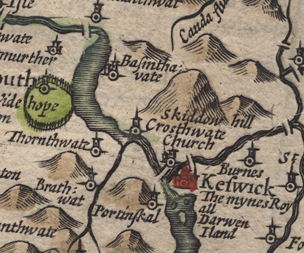 SP11NY22.jpg outline, shaded item:- private collection : 16 Image © see bottom of page |
|||||||||||||||||||||||||
|
|
||||||||||||||||||||||||||
| evidence:- | old map:- Jansson 1646 |
|||||||||||||||||||||||||
| source data:- | Map, hand coloured engraving, Cumbria and Westmoria, ie
Cumberland and Westmorland, scale about 3.5 miles to 1 inch, by
John Jansson, Amsterdam, Netherlands, 1646.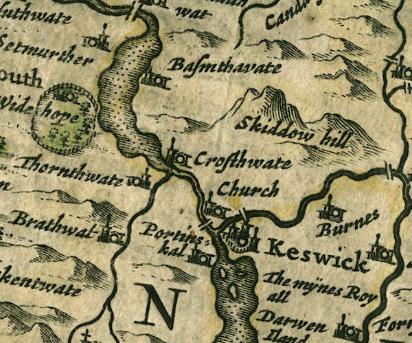 JAN3NY22.jpg Outline with shore shaded, dotted area. item:- JandMN : 88 Image © see bottom of page |
|||||||||||||||||||||||||
|
|
||||||||||||||||||||||||||
| evidence:- | old map:- Ogilby 1675 (plate 96) |
|||||||||||||||||||||||||
| source data:- | Road strip map, hand coloured engraving, the Road from Kendal to
Cockermouth, and the Road from Egremond to Carlisle, scale about
1 inch to 1 mile, by John Ogilby, London, 1675. OG96m035.jpg In miles 35 to 38, Cumberland. Lake on the left of the road for 3 miles. item:- JandMN : 22 Image © see bottom of page |
|||||||||||||||||||||||||
|
|
||||||||||||||||||||||||||
| evidence:- | old map:- Sanson 1679 |
|||||||||||||||||||||||||
| source data:- | Map, hand coloured engraving, Ancien Royaume de Northumberland
aujourdhuy Provinces de Nort, ie the Ancient Kingdom of
Northumberland or the Northern Provinces, scale about 9.5 miles
to 1 inch, by Nicholas Sanson, Paris, France, 1679. click to enlarge click to enlargeSAN2Cm.jpg outline, shore shaded; lake item:- Dove Cottage : 2007.38.15 Image © see bottom of page |
|||||||||||||||||||||||||
|
|
||||||||||||||||||||||||||
| evidence:- | old map:- Seller 1694 (Cmd) |
|||||||||||||||||||||||||
| source data:- | Map, uncoloured engraving, Cumberland, scale about 12 miles to 1
inch, by John Seller, 1694. click to enlarge click to enlargeSEL9.jpg outline with shaded shore; lake item:- Dove Cottage : 2007.38.89 Image © see bottom of page |
|||||||||||||||||||||||||
|
|
||||||||||||||||||||||||||
| evidence:- | old map:- Morden 1695 (Cmd) |
|||||||||||||||||||||||||
| source data:- | Map, uncoloured engraving, Cumberland, scale about 4 miles to 1
inch, by Robert Morden, 1695, published by Abel Swale, the
Unicorn, St Paul's Churchyard, Awnsham, and John Churchill, the
Black Swan, Paternoster Row, London, 1695-1715.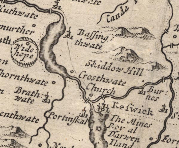 MD12NY22.jpg Outline with shore shading. item:- JandMN : 90 Image © see bottom of page |
|||||||||||||||||||||||||
|
|
||||||||||||||||||||||||||
| evidence:- | old map:- Badeslade 1742 placename:- |
|||||||||||||||||||||||||
| source data:- | Map, uncoloured engraving, A Map of Cumberland North from
London, scale about 11 miles to 1 inch, with descriptive text,
by Thomas Badeslade, London, engraved and published by William
Henry Toms, Union Court, Holborn, London, 1742. click to enlarge click to enlargeBD10.jpg "" outline with form lines item:- JandMN : 115 Image © see bottom of page |
|||||||||||||||||||||||||
|
|
||||||||||||||||||||||||||
| evidence:- | old text:- Gents Mag placename:- Basingthwaite |
|||||||||||||||||||||||||
| source data:- | Magazine, The Gentleman's Magazine or Monthly Intelligencer or
Historical Chronicle, published by Edward Cave under the
pseudonym Sylvanus Urban, and by other publishers, London,
monthly from 1731 to 1922. goto source goto sourceGentleman's Magazine 1751 p.52 "... the lake of Basingthwaite, which is about one mile wide and 5 miles long, and on the opposite side Widehope fells, with their impending woods, form a very pleasing and romantic appearance. ..." |
|||||||||||||||||||||||||
|
|
||||||||||||||||||||||||||
| evidence:- | old map:- Gents Mag 1751 placename:- Bassinwaite Water |
|||||||||||||||||||||||||
| source data:- | Map, uncoloured engraving, Map of the Black Lead Mines in
Cumberland, and area, scale about 2 miles to 1 inch, by George
Smith, published in the Gentleman's Magazine, 1751.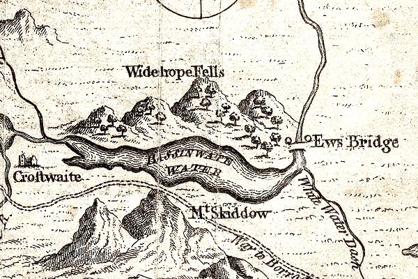 GM1312.jpg "BASSINWAITE WATER" outline with form lines; lake item:- JandMN : 114 Image © see bottom of page |
|||||||||||||||||||||||||
|
|
||||||||||||||||||||||||||
| evidence:- | old map:- Donald 1774 (Cmd) placename:- Bassenthwaite Water |
|||||||||||||||||||||||||
| source data:- | Map, hand coloured engraving, 3x2 sheets, The County of Cumberland, scale about 1
inch to 1 mile, by Thomas Donald, engraved and published by Joseph Hodskinson, 29
Arundel Street, Strand, London, 1774.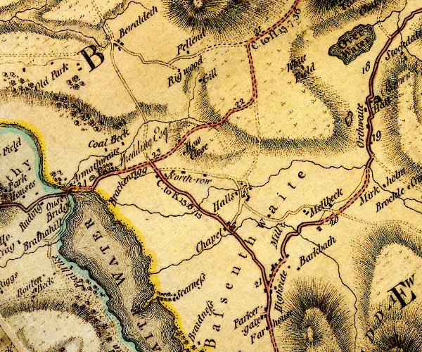 D4NY23SW.jpg 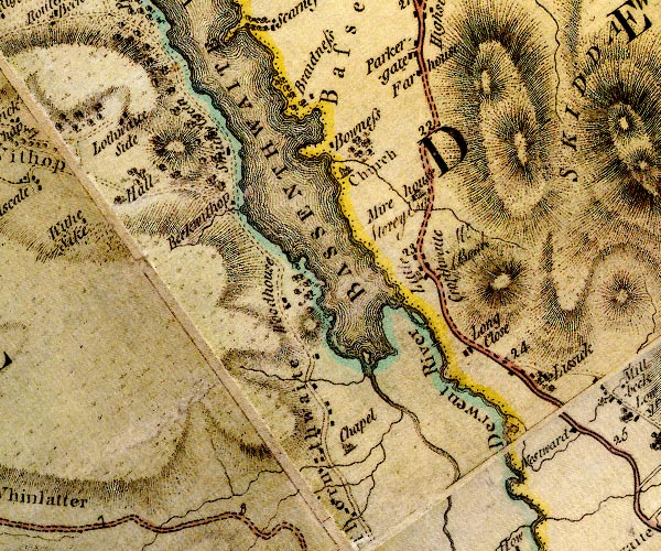 D4NY22NW.jpg "BASSENTHWAITE WATER" lake item:- Carlisle Library : Map 2 Images © Carlisle Library |
|||||||||||||||||||||||||
|
|
||||||||||||||||||||||||||
| evidence:- | descriptive text:- West 1778 (11th edn 1821) placename:- Bassenthwaite Water |
|||||||||||||||||||||||||
| source data:- | Guide book, A Guide to the Lakes, by Thomas West, published by
William Pennington, Kendal, Cumbria once Westmorland, and in
London, 1778 to 1821. goto source Page 118:- "..." "BASSENTHWAITE-WATER." "..." goto sourcePage 119:- "Mr. Pennant says, '... this lake is a fine expanse of 4 miles in length, bounded on one side by high hills, wooded in many places to their bottoms; on the other side, by fields, and the skirts of Skiddaw. ...'" "Mr. Gray ... '... a very beautiful view opens down to the lake, which is narrower and longer than that of Keswick, less broken into bays, and without islands; ...'" "..." goto sourcePage 190:- "A TABLE OF THE Height of Mountains and Lakes SEEN IN THIS TOUR, ... TAKEN FROM THE LEVEL OF THE SEA. ... by Mr. John Dalton." "Bassenthwaite-water ... 70 [yards]" |
|||||||||||||||||||||||||
|
|
||||||||||||||||||||||||||
| evidence:- | old map:- Crosthwaite 1783-94 (Bas) placename:- Broadwater placename:- Bassenthwaite Lake |
|||||||||||||||||||||||||
| source data:- | Map, uncoloured engraving, An Accurate Map of Broadwater or
Bassenthwaite Lake, scale about 3 inches to 1 mile, by Peter
Crosthwaite, Keswick, Cumberland, 1783, version published 1800.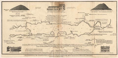 click to enlarge click to enlargeCT06.jpg "An Accurate MAP of BROADWATER or BASSENTHWAITE LAKE ..." "NB. The Author Surveyed this Lake in October 1784, after Six Weeks of Fair Weather vizt. at Low water." "Adorn'd with Giant Skiddow on the East, / The Towering Banks of Withope on the West; / The North displays much Cultivated Land; / The South the Vale of Keswick ever grand, / And winding Shoars with variegated Wood; / Compleat the Scene and Circumscribe the Flood." "Lat. 54[d]:367[m]N. Lon. 3[d]:18[m]W" Depth soundings are given:- "... the Figures upon the Lake are Fathoms." and the current in the lake is indicated:- "NB. The 5 arrows point down the Lake, ..." item:- Armitt Library : 1959.191.4 Image © see bottom of page |
|||||||||||||||||||||||||
|
|
||||||||||||||||||||||||||
| evidence:- | old map:- West 1784 map placename:- Bassenthwaite Water |
|||||||||||||||||||||||||
| source data:- | Map, hand coloured engraving, A Map of the Lakes in Cumberland,
Westmorland and Lancashire, scale about 3.5 miles to 1 inch,
engraved by Paas, 53 Holborn, London, about 1784. Ws02NY23.jpg 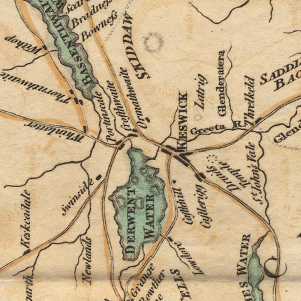 Ws02NY22.jpg "BASSENTHWAITE WATER" item:- Armitt Library : A1221.1 Image © see bottom of page |
|||||||||||||||||||||||||
| source data:- | Map, hand coloured engraving, A Map of the Lakes in Cumberland,
Westmorland and Lancashire, scale about 3.5 miles to 1 inch,
engraved by Paas, 53 Holborn, London, about 1784. item:- Armitt Library : A1221.1 Image © see bottom of page |
|||||||||||||||||||||||||
|
|
||||||||||||||||||||||||||
| evidence:- | old text:- Clarke 1787 placename:- Broad Water placename:- Bassenthwaite Water item:- fishery; Bassenthwaite Lake; Ewes Bridge fishery; Stone Wall fishery; Eller Stile fishery; Eller Lake fishery; fish, Bassenthwaite Lake |
|||||||||||||||||||||||||
| source data:- | Guide book, A Survey of the Lakes of Cumberland, Westmorland,
and Lancashire, written and published by James Clarke, Penrith,
Cumberland, and in London etc, 1787; published 1787-93. goto source Page 95:- "..." "THE Lake Broad-Water, commonly called Bassenthwaite-Water, is the property of the Earl of Egremont, both for fishing and navigation; for in the year 1772 the right to this Lake was tried at the Assizes holden at Carlisle, in a cause between the Earl of Egremont plaintiff; (or his trustees or agents, I cannot tell which, though I attended and drew the plans for the Earl's counsel, as the Earl then wanted four months of age, for he was born the 7th December 1751,) and Sir Gilfrid Lawson, Baronet, John Spedding, Esq; Thomas Storey, Esq; and others, the freeholders of Bassenthwaite, defendants, when the following issues were found for the Earl, viz." "That the said water called Broad-Water, and every part thereof, is the freehold of the Earl of Egremont." "That the Earl is seised of a separate fishery in the whole; except three draughts, viz. Ewes-Bridge, Stone-Wall, Eller-Stile, or Eller-Lake, wherein John Spedding, Esq; hath the free fishery in common with the said Earl; and as that owner of the fishery, he the said Earl and his tenants are intitled to the privilege of drawing and landing their nets used in the said fishery upon any of the grounds adjoining the Lake." "And that the earl is entitled to the sole navigation of the Lake, and hath liberty to land goods upon any of the grounds adjoining the Lake out of any boat or vessel navigating upon the Lake." "Those issues appeared to me to be a very great hardship upon the inhabitants, and very little to the advantage to the Earl, (who does not make twenty shillings a year of it:) many of them keep boats for pleasure, and navigating now and then a little wood, hay, straw, &c. and also went a fishing at pleasure. These were not the poorer sort, therefore could not be said to encourage idleness; as it is not worth building a boat for the sake of fishing only, here being no fish but pike and perch, and those when caught sell only for a penny a pound: yet a man, with one or two of his sons, and perhaps a visiting relation, could not go upon the Lake in an evening for" |
|||||||||||||||||||||||||
| source data:- | goto source Page 96:- "amusement, and with their lines kill ten or twelve pound of fish; which were perhaps a feast to a friend, of use to a family, a refreshment from hard labour, and a Saturday afternoon's diversion for a school-boy." "The Bailiff, like most others, wanting to make something more of his place, or please his lord by encroachments, made some of the freeholders, and others, (tenants at will under the freeholders, who were to keep in repair their landlord's boat and use it,) pay a little; as appeared by the evidence of himself and others: some gave him a day-reaping for what they called boat-gate, some half a day mowing, some a cow-bulling, and one a pennyworth of candle-seeves; all which payments gave a handle for the counsel." "The Lake contains 1747 acres at low water, and is shallow, (as appears by the soundings) of a soft muddy bottom; where very shallow, it has, like all the others, a grassy bottom. Some of our writers, (West and Hutchinson) describing the transparency of this and Derwent Lake, say they can see small white pebble stones a great depth shining like diamonds. This I deny; but they, in describing and extolling those places, often overdo it, especially West in the last edition. In this he tells us, that he thinks a work of this kind will not do in plain language: I cannot, however, help differing from him, as, in my opinion, plain facts are best told in plain language. ..." |
|||||||||||||||||||||||||
|
|
||||||||||||||||||||||||||
| evidence:- | old map:- Clarke 1787 map (Bassenthwaite Lake) placename:- Ousebridge Dub placename:- Stone Wall Dub placename:- Eller Lake Dub placename:- Eller Stile Dub |
|||||||||||||||||||||||||
| source data:- | Map, A Map of Broadwater and its Environs, ie Bassenthwaite
Lake, scale about 6.5 ins to 1 mile, by James Clarke, engraved
by Neele, 352 Strand, published by James Clarke, Penrith,
Cumberland and in London etc, 1787.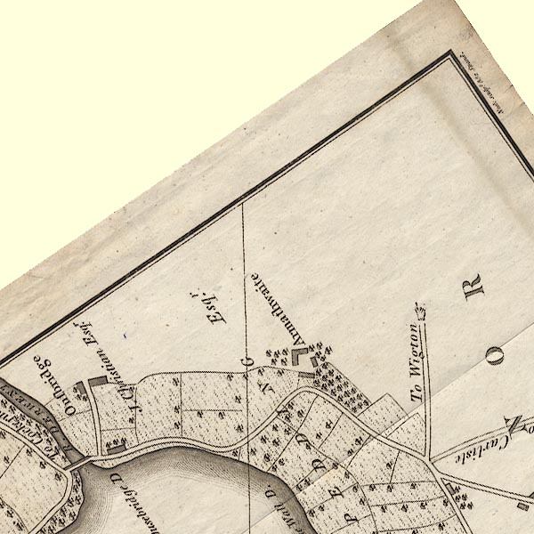 CL8NY23B.jpg "Ousebridge D" 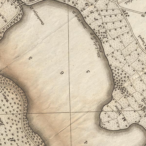 CL8NY23A.jpg "Stone Wall D." "Eller Lake or Eller Stile D" item:- private collection : 10.8 Image © see bottom of page |
|||||||||||||||||||||||||
|
|
||||||||||||||||||||||||||
| evidence:- | old map:- Clarke 1787 map (Bassenthwaite Lake) placename:- Broadwater |
|||||||||||||||||||||||||
| source data:- | Map, A Map of Broadwater and its Environs, ie Bassenthwaite
Lake, scale about 6.5 ins to 1 mile, by James Clarke, engraved
by Neele, 352 Strand, published by James Clarke, Penrith,
Cumberland and in London etc, 1787.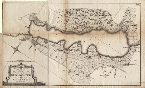 click to enlarge click to enlargeCL08.jpg "A MAP of BROADWATER, and its ENVIRONS. Surveyed by James Clarke. / Published Feby. 10th. 1787, by James Clarke, Penrith." item:- private collection : 10.8 Image © see bottom of page |
|||||||||||||||||||||||||
|
|
||||||||||||||||||||||||||
| evidence:- | old text:- Camden 1789 (Gough Additions) placename:- Broadwater |
|||||||||||||||||||||||||
| source data:- | Book, Britannia, or A Chorographical Description of the Flourishing Kingdoms of England,
Scotland, and Ireland, by William Camden, 1586, translated from the 1607 Latin edition
by Richard Gough, published London, 1789. goto source Page 182:- "..." "Skiddaw ... rises gently 1100 yards perpendicular from the broadwater ..." |
|||||||||||||||||||||||||
|
|
||||||||||||||||||||||||||
| evidence:- | old map:- Aikin 1790 (Cmd) placename:- |
|||||||||||||||||||||||||
| source data:- | Map, uncoloured engraving, Cumberland, by John Aikin, London,
1790. click to enlarge click to enlargeAIK3.jpg "" outline with form lines; lake item:- JandMN : 145 Image © see bottom of page |
|||||||||||||||||||||||||
|
|
||||||||||||||||||||||||||
| evidence:- | old map:- Bailey 1797 placename:- Basinthwaite Water |
|||||||||||||||||||||||||
| source data:- | Map, soil etc, uncoloured engraving, Cumberland, scale about 21
miles to 1 inch, by J Bailey, engraved by Neele, Strand,
published by Messrs Robinson, Paternoster Row and G Nicol, Pall
Mall, London, 1797. click to enlarge click to enlargeBY04.jpg "Basinthwaite Water" outline with form lines; lake item:- Armitt Library : A680.2 Image © see bottom of page |
|||||||||||||||||||||||||
|
|
||||||||||||||||||||||||||
| evidence:- | old map:- Housman 1800 map 3 placename:- Bassenthwaite Water |
|||||||||||||||||||||||||
| source data:- | Maps, hand coloured engraving, Lakes in Cumberland, 9 lakes on one sheet, engraved
by James Lowes, published by F Jollie, Carlisle, Cumberland, and C Law, Ave Maria
Lane, London, 1800. click to enlarge click to enlargeHM01Bas.jpg "BASSENTHWAITE WATER" item:- Dove Cottage : 2007.38.96 Image © see bottom of page |
|||||||||||||||||||||||||
|
|
||||||||||||||||||||||||||
| evidence:- | old map:- Cooke 1802 placename:- Bassenthwaite Water |
|||||||||||||||||||||||||
| source data:- | Map, The Lakes, Westmorland and Cumberland, scale about 8.5
miles to 1 inch, engravedby Neele and Son, published by
Sherwood, Jones and Co, Paternoster Road, London, 1824. click to enlarge click to enlargeGRA1Lk.jpg "Bassenthwaite W." outline with form lines; lake or tarn item:- Hampshire Museums : FA2000.62.5 Image © see bottom of page |
|||||||||||||||||||||||||
|
|
||||||||||||||||||||||||||
| evidence:- | old map:- Cooke 1802 placename:- Bassenthwaite Water |
|||||||||||||||||||||||||
| source data:- | Map, Cumberland, scale about 15.5 miles to 1 inch, by George
Cooke, 1802, bound in Gray's New Book of Roads, 1824, published
by Sherwood, Jones and Co, Paternoster Road, London, 1824. click to enlarge click to enlargeGRA1Cd.jpg "Bassenthwaite Water" outline with form lines; lake or tarn item:- Hampshire Museums : FA2000.62.2 Image © see bottom of page |
|||||||||||||||||||||||||
|
|
||||||||||||||||||||||||||
| evidence:- | old print:- Green 1804 (plate 19) placename:- Bassenthwaite Water |
|||||||||||||||||||||||||
| source data:- | Print, uncoloured aquatint, Bassenthwaite Water, from the Western side, Cumberland,
by William Green, Ambleside, Westmorland, 1804.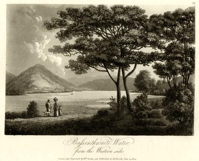 click to enlarge click to enlargeGN1619.jpg Plate 19 from a series. printed at bottom:- "Bassenthwaite Water, / from the Western side. / Drawn and Engraved by Wm. Green, and Published at Ambleside, June 24, 1804." printed at top right:- "19" item:- Armitt Library : 2014.166 Image © see bottom of page |
|||||||||||||||||||||||||
|
|
||||||||||||||||||||||||||
| evidence:- | old text:- Gents Mag |
|||||||||||||||||||||||||
| source data:- | Magazine, The Gentleman's Magazine or Monthly Intelligencer or
Historical Chronicle, published by Edward Cave under the
pseudonym Sylvanus Urban, and by other publishers, London,
monthly from 1731 to 1922. goto source Gentleman's Magazine 1805 p.1122 "... When I first beheld the Lakes of Derwent and Bassenthwaite, I could not easily divest my mind of a persuasion that thay had once been united, and that the intervening plain had originally formed the bed of the water. Such an alteration, taken as a whole, might powerfully contribute to the scenic consistency of the valley; but perhaps an expanse so equally extensive would rather degenerate into tameness, than raise the landscape in the scale of grandeur. ..." |
|||||||||||||||||||||||||
|
|
||||||||||||||||||||||||||
| evidence:- | old map:- Laurie and Whittle 1806 placename:- Bassenthwaite Water |
|||||||||||||||||||||||||
| source data:- | Road map, Completion of the Roads to the Lakes, scale about 10
miles to 1 inch, by Nathaniel Coltman? 1806, published by Robert
H Laurie, 53 Fleet Street, London, 1834. click to enlarge click to enlargeLw18.jpg "Bassenthwaite Water" lake item:- private collection : 18.18 Image © see bottom of page |
|||||||||||||||||||||||||
|
|
||||||||||||||||||||||||||
| evidence:- | old map:- Cooper 1808 placename:- Broad Water |
|||||||||||||||||||||||||
| source data:- | Map, uncoloured engraving, Cumberland, scale about 10.5 miles to
1 inch, drawn and engraved by Cooper, published by R Phillips,
Bridge Street, Blackfriars, London, 1808. click to enlarge click to enlargeCOP3.jpg "Broad W." outline, shaded; lake item:- JandMN : 86 Image © see bottom of page |
|||||||||||||||||||||||||
|
|
||||||||||||||||||||||||||
| evidence:- | old map:- Wallis 1810 (Cmd) placename:- Bassenthwaite Water |
|||||||||||||||||||||||||
| source data:- | Road map, hand coloured engraving, Cumberland, scale about 16
miles to 1 inch, by James Wallis, 77 Berwick Stree, Soho,
London, 1810. click to enlarge click to enlargeWL13.jpg "Bassenthwaite Water" outline, shaded; lake item:- Dove Cottage : 2009.81.10 Image © see bottom of page |
|||||||||||||||||||||||||
|
|
||||||||||||||||||||||||||
| evidence:- | old print:- Wilkinson 1810 (plate 38) placename:- Bassenthwaite Lake |
|||||||||||||||||||||||||
| source data:- | Print, uncoloured soft ground etching, Bassenthwaite Lake from Embleton Vale, Cumberland,
by Joseph Wilkinson, engraved by William Frederick Wells, published by R Ackermann,
Repository of Arts, 101 Strand, London, 1810.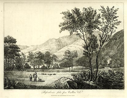 click to enlarge click to enlargeWKN138.jpg Plate 38 in Select Views in Cumberland, Westmoreland, and Lancashire. printed at bottom left, right, centre:- "Revd. J. Wilkinson delt. / W. F. Wells sc. / Bassenthwaite Lake from Embleton Vale. / Published July 1. 1810. by R. Ackermann. 101. Strand. London." item:- Fell and Rock Climbing Club : MN4.38 Image © see bottom of page |
|||||||||||||||||||||||||
|
|
||||||||||||||||||||||||||
| evidence:- | old print:- Green 1815 placename:- Bassenthwaite Water |
|||||||||||||||||||||||||
| source data:- | Print, coloured aquatint, Bassenthwaite Water, Bassenthwaite etc, Cumberland, by William
Green, Ambleside, Westmorland, 1815.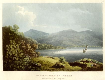 click to enlarge click to enlargeGN0540.jpg Plate 43 in Lake Scenery. printed at upper right:- "43" printed at bottom:- "BASSENTHWAITE WATER. / Published at Ambleside, June 1, 1815, by Wm. Green." item:- Armitt Library : A6646.40 Image © see bottom of page |
|||||||||||||||||||||||||
|
|
||||||||||||||||||||||||||
| evidence:- | old print with text:- Farington 1816 placename:- Bassenthwaite Lake placename:- Broad Water |
|||||||||||||||||||||||||
| source data:- | Print, uncoloured engraving and descriptive text, Bassenthwaite Lake, from the Hill
above Armathwaite, Cumberland, drawn by Joseph Farington, engraved by F R Hay, published
by T Cadell and W Davies, Strand, London, 1815. click to enlarge click to enlargeFA0419.jpg printed, bottom left, right, centre "Drawn by J. Farington R.A. / Engraved by F. R. Hay. / Bassenthwaite Lake, from the Hill above Armathwaite. / London Published Septr. 15, 1815, by T. Cadell &W. Davies, Strand." Descriptive text:- "BASSENTHWAITE LAKE FROM THE HILL ABOVE ARMATHWAITE." "BASSENTHWAITE LAKE, which is sometimes called Broad Water, is nearly three miles north of Derwentwater; having in the east the beautiful and extensive vale of Bassenthwaite, with the mighty Skiddaw rearing its lofty head behind it, and on the west a range of humble mountains, that fall abruptly to the water's edge, and only admit of cultivation in small patches. These declivities, called Wythop-Brows, are partly rocky, and partly covered with thick woods rising from the margin of the Lake. Our view is taken from the hill above the little village of Armathwaite, situated at the north end of the Lake. Wythop woods cover the hills on the west side of the Lake, and the foot of Skiddaw forms the opposite boundary of the vale, while over a line of flat land at the south end of the Lake, a small part of Derwentwater appears, and the rocks and mountains which rise above it. Bassenthwaite Lake is nearly a mile in breadth, at its northern extremity; but lower down it decreases to little more than a quarter of a mile; its length is computed to be about four miles." item:- Armitt Library : A6666.19 Image © see bottom of page |
|||||||||||||||||||||||||
|
|
||||||||||||||||||||||||||
| evidence:- | old map:- Otley 1818 placename:- Bassenthwaite |
|||||||||||||||||||||||||
| source data:- | Map, uncoloured engraving, The District of the Lakes,
Cumberland, Westmorland, and Lancashire, scale about 4 miles to
1 inch, by Jonathan Otley, 1818, engraved by J and G Menzies,
Edinburgh, Scotland, published by Jonathan Otley, Keswick,
Cumberland, et al, 1833. OT02NY23.jpg  OT02NY22.jpg "BASSENTHWAITE" item:- JandMN : 48.1 Image © see bottom of page |
|||||||||||||||||||||||||
|
|
||||||||||||||||||||||||||
| evidence:- | old map:- Hall 1820 (Cmd) placename:- Bassenthwaite Water |
|||||||||||||||||||||||||
| source data:- | Map, hand coloured engraving, Cumberland, scale about 21 miles
to 1 inch, engraved by Sidney Hall, published by S Leigh, 18
Strand, London, 1820-31. click to enlarge click to enlargeHA14.jpg "Bassenthwaite Water" outline, shaded; lake item:- JandMN : 91 Image © see bottom of page |
|||||||||||||||||||||||||
|
|
||||||||||||||||||||||||||
| evidence:- | old print:- Fielding and Walton 1821 (plate 37) placename:- Bassenthwaite Lake |
|||||||||||||||||||||||||
| source data:- | Print, coloured aquatint, Bassenthwaite Lake, Cumberland, drawn by Theodore H A Fielding,
published by R Ackermann, 101 Strand, London, 1821.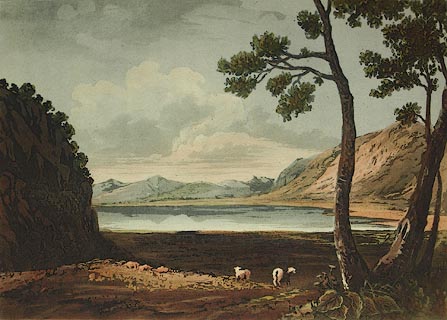 click to enlarge click to enlargeFW0137.jpg Tipped in opposite p.241 in A Picturesque Tour of the English Lakes. item:- Dove Cottage : 1993.R566.37 Image © see bottom of page |
|||||||||||||||||||||||||
|
|
||||||||||||||||||||||||||
| evidence:- | descriptive text:- Otley 1823 (5th edn 1834) item:- fishing; perch; salmon; pike; depth, Bassenthwaite Lake |
|||||||||||||||||||||||||
| source data:- | Guide book, A Concise Description of the English Lakes, the
mountains in their vicinity, and the roads by which they may be
visited, with remarks on the mineralogy and geology of the
district, by Jonathan Otley, published by the author, Keswick,
Cumberland now Cumbria, by J Richardson, London, and by Arthur
Foster, Kirkby Lonsdale, Cumbria, 1823; published 1823-49,
latterly as the Descriptive Guide to the English Lakes. goto source Page 22:- "BASSENTHWAITE LAKE" "Is of somewhat greater length than Derwent, but of less breadth, and without islands. Being further from the mountains, it is not viewed with the same interest as some other lakes. Its western side is rather too uniformly wooded, the eastern has a greater breadth of cultivation, on which side are some fine bays and promontories; but here the road recedes too far from the lake to exhibit it to advantage. However, tourists who have leisure for a ride or a drive of eighteen miles, round this lake, may obtain some pleasing views; especially from the foot of the lake, and from some points of Wythop woods. This lake is of less depth than Derwent: pike and perch are the principal fish; salmon pass through it, to deposit their spawn in the rivers Derwent and Greta, but are seldom met with in the lake." "..." goto source"This being thought less interesting than most of the other lakes, is often reserved to the last; but some have remarked that it ought to be visited first, or before the imagination became too much elated by the more prominent features of the other lakes. ..." |
|||||||||||||||||||||||||
|
|
||||||||||||||||||||||||||
| evidence:- | old map:- Perrot 1823 |
|||||||||||||||||||||||||
| source data:- | Map, hand coloured engraving, Cumberland and Westmoreland ie
Westmorland, scale about 38 miles to 1 inch, by Aristide Michel
Perrot, engraved by Migneret, 1823, published by Etienne Ledoux,
9 Rue Guenegaud, Paris, France, 1824-48. click to enlarge click to enlargePER2.jpg outline with form lines; lake item:- Dove Cottage : 2007.38.45 Image © see bottom of page |
|||||||||||||||||||||||||
|
|
||||||||||||||||||||||||||
| evidence:- | old print:- Westall 1830s placename:- Bassenthwaite Lake |
|||||||||||||||||||||||||
| source data:- | Print, aquatint panorama, Bassenthwaite Lake, from the Keswick Road, near the 6 Mile
Stone, Cumberland, drawn and engraved by William Westall, published by Ackermann and
Co, 96 Strand, London, 1835.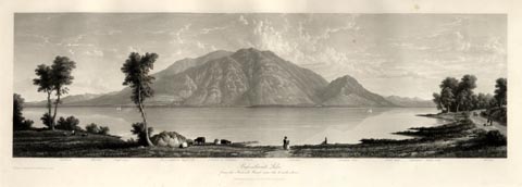 click to enlarge click to enlargeWTL316.jpg "Caldbeck. Westfell. Dead crags. Bassenthwaite high side. Summit of Skiddaw. Ullock. Carlside. Skiddaw dod. Great dod. Helvellen. Walla crag. Catbell. / Drawn & Engraved by W. Westall A.R.A. / Bassenthwaite Lake, from the Keswick Road, near the 6 mile stone. / Published by Ackermann and Co, 96 Strand. 1835." item:- Armitt Library : A6658.16 Image © see bottom of page |
|||||||||||||||||||||||||
|
|
||||||||||||||||||||||||||
| evidence:- | descriptive text:- Ford 1839 (3rd edn 1843) placename:- Bassenthwaite Water placename:- Bassenthwaite Lake item:- depth, Bassenthwaite Lake |
|||||||||||||||||||||||||
| source data:- | Guide book, A Description of Scenery in the Lake District, by
Rev William Ford, published by Charles Thurnam, Carlisle, by W
Edwards, 12 Ave Maria Lane, Charles Tilt, Fleet Street, William
Smith, 113 Fleet Street, London, by Currie and Bowman,
Newcastle, by Bancks and Co, Manchester, by Oliver and Boyd,
Edinburgh, and by Sinclair, Dumfries, 1839. goto source Page 85:- "..." "BASSENTHWAITE WATER" "Is four miles in length, and in some places almost one mile in breadth. Lying on the edge as it were of the mountain district, it is not viewed with the same interest as the others, being less in magnitude and inferior in beauty and grandeur. It has no islands. Its western side is bounded by the Wythop Woods and Lord's Seat, which approach close to the water's brink. Its eastern side is indented by several pretty bays and promontories, as Bradness and Scarness, which present excellent views, and rich cultivated grounds occupy the space between the margin of the lake and the lofty Skiddaw with" goto sourcePage 86:- "his Dodd; on the south are the flats irrigated by the Derwent, its main feeder; and on the north are the beautiful park-grounds of Armathwaite Hall with Binsey behind. Pike and perch are its principal fish, and salmon pass through to deposit their spawn in the Derwent." "The road passing through the woods of Wythop, which are too thick and umbrageous, though affording here and there partial views of the lake and Skiddaw, we should recommend going round the foot of the lake, and passing by its eastern side to Keswick. The tourist must ascend the road as it rises up the hill, leading towards Ireby, and when immediately above the Haws village, he will have the whole vale below on the right hand, a scene of rich cultivation waving with the golden harvest, the lake stretching along, gleaming and flashing under the dark woods of Wythop; houses, hamlets, woods, and the far-spreading landscape, fading away in the blue mountains heaped together about the head of Derwent Water. This is a view for beauty, grandeur, and magnificence, which has not its superior. ..." goto sourcePage 87:- "... Follow the higher road of the two, to Keswick, because its elevation gives a greater command over the details of the valley, and a peep of the lake. You come into the low road, where a branch leads off to the church, ... on the margin of the lake, not far from the promontories of Bradness and Scarness. On the direct road to Keswick, on the right, is Mirehouse, ... The upper end of Bassenthwaite has been said to bear some resemblance to the Lake of Como. ..." goto sourcePage 177:- "A TABLE" "OF THE LENGTH, BREADTH, &c. OF THE LAKES," "COLLECTED FROM DIFFERENT AUTHORITIES."
|
|||||||||||||||||||||||||
|
|
||||||||||||||||||||||||||
| evidence:- | old map:- Ford 1839 map placename:- Bassenthwaite Water |
|||||||||||||||||||||||||
| source data:- | Map, uncoloured engraving, Map of the Lake District of
Cumberland, Westmoreland and Lancashire, scale about 3.5 miles
to 1 inch, published by Charles Thurnam, Carlisle, and by R
Groombridge, 5 Paternoster Row, London, 3rd edn 1843. FD02NY22.jpg "Bassenthwaite Wr." Outline with form lines. item:- JandMN : 100.1 Image © see bottom of page |
|||||||||||||||||||||||||
|
|
||||||||||||||||||||||||||
| evidence:- | old map:- Ford 1839 map placename:- Bassenthwaite Water |
|||||||||||||||||||||||||
| source data:- | Map, uncoloured engraving, Map of the Lake District of
Cumberland, Westmoreland and Lancashire, scale about 3.5 miles
to 1 inch, published by Charles Thurnam, Carlisle, and by R
Groombridge, 5 Paternoster Row, London, 3rd edn 1843. FD02NY23.jpg "Bassenthwaite Wr." Outline with form lines. item:- JandMN : 100.1 Image © see bottom of page |
|||||||||||||||||||||||||
|
|
||||||||||||||||||||||||||
| evidence:- | old map:- Wyld 1847 placename:- Bassenthwaite Lake |
|||||||||||||||||||||||||
| source data:- | Map, uncoloured engraving, Thirlmere, Derwentwater, and
Bassenthwaite Lakes, scale about 3.5 miles to 1 inch, by James
Wyld, published by John Johnstone, Paternoster Row, London, et
al, 1847.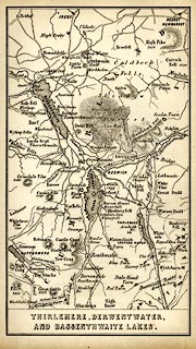 click to enlarge click to enlargeWLD3M2.jpg printed at bottom:- "THIRLMERE, DERWENTWATER, / AND BASSENTHWAITE LAKES." item:- Armitt Library : A1201.65 Image © see bottom of page |
|||||||||||||||||||||||||
|
|
||||||||||||||||||||||||||
| evidence:- | old map:- Garnett 1850s-60s H placename:- Bassenthwaite Water |
|||||||||||||||||||||||||
| source data:- | Map of the English Lakes, in Cumberland, Westmorland and
Lancashire, scale about 3.5 miles to 1 inch, published by John
Garnett, Windermere, Westmorland, 1850s-60s. GAR2NY13.jpg  GAR2NY22.jpg "BASSENTHWAITE WR." outline with shore form lines, lake or tarn item:- JandMN : 82.1 Image © see bottom of page |
|||||||||||||||||||||||||
|
|
||||||||||||||||||||||||||
| evidence:- | old print:- Pyne 1853 placename:- Bassenthwaite Lake |
|||||||||||||||||||||||||
| source data:- | Print, tinted lithograph, Bassenthwaite Lake, Vale and Village, Bassenthwaite, Cumberland,
by James Baker Pyne, engraved by W Gauci, published by Thomas Agnew and Sons, Manchester,
Lancashire, 1853.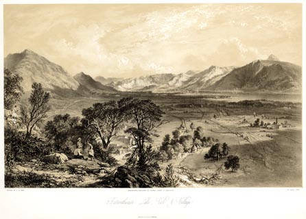 click to enlarge click to enlargePYN216.jpg "PAINTED BY J. B. PYNE. / W. GAUCI LITH. / MANCHESTER, PUBLISHED BY THOMAS AGNEW & SONS, 1853. / Bassenthwaite Lake, Vale & Village. / M & N HANHART IMPT." item:- Armitt Library : A6678.17 Image © see bottom of page |
|||||||||||||||||||||||||
|
|
||||||||||||||||||||||||||
| evidence:- | old print:- Pyne 1853 placename:- Bassenthwaite Lake |
|||||||||||||||||||||||||
| source data:- | Print, coloured lithograph, Bassenthwaite Lake, Vale and Village, Bassenthwaite, Cumberland,
by James Baker Pyne, engraved by W Gauci, published by Thomas Agnew and Sons, Manchester,
Lancashire, 1853.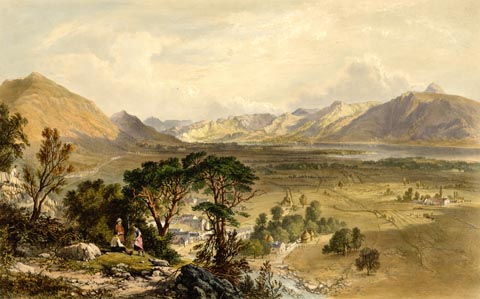 click to enlarge click to enlargePYN416.jpg item:- Armitt Library : A6677.17 Image © see bottom of page |
|||||||||||||||||||||||||
|
|
||||||||||||||||||||||||||
| evidence:- | old text:- Martineau 1855 |
|||||||||||||||||||||||||
| source data:- | Guide book, A Complete Guide to the English Lakes, by Harriet
Martineau, published by John Garnett, Windermere, Westmorland,
and by Whittaker and Co, London, 1855; published 1855-76. goto source Page 88:- "Bassenthwaite is perhaps the last of the lakes to be visited, unless it be Hawes Water. ... Bassenthwaite verges towards the flat country, which is not what the traveller came to visit. It is amusing to observe how the residents in the district become more sensible every year to the beauty of the merely undulating country through which the mountains sink into the plains: while strangers have hardly patience to look at it, in their eagerness to find themselves under the shadow of the great central fells. Bassenthwaite is one of the outermost lakes; and it is therefore no more cared for by the tourists in general than the foot of Coniston or Windermere. Still, considering that Skiddaw overshadows its eastern shore, it would seem worthy of some attention; and the drive of eighteen miles round it is, in truth, a very pleasant one." "This lake is larger than Derwent Water, being four miles in length and one mile in breadth. The distance" goto sourcePage 89:- "from lake to lake is between three and four miles, a large proportion of which is apt to be flooded in winter; and occasionally the waters actually join, so as to present the appearance of a lake of ten miles long,- the length of Windermere. These floods are a serious drawback to the productiveness of the lake levels, and the health and comfort of the inhabitants." |
|||||||||||||||||||||||||
|
|
||||||||||||||||||||||||||
| evidence:- | old text:- Martineau 1855 placename:- Bassenthwaite Water item:- depth, Bassenthwaite Lake |
|||||||||||||||||||||||||
| source data:- | Guide book, A Complete Guide to the English Lakes, by Harriet
Martineau, published by John Garnett, Windermere, Westmorland,
and by Whittaker and Co, London, 1855; published 1855-76. goto source Page 180:- "A TABLE OF THE LENGTH, BREADTH, AND DEPTH OF THE LAKES." "No. : Names of Lakes. : Counties : Length in Miles. : Extreme breadth in Miles : Extreme depth in Feet : Height above the Sea" "10 : Bassenthwaite Water : Cumberland : 4 : 1 : 68 : 210" |
|||||||||||||||||||||||||
|
|
||||||||||||||||||||||||||
| evidence:- | old map:- Mill and Heawood 1895 placename:- Bassenthwaite Lake |
|||||||||||||||||||||||||
| source data:- | Map, Bassenthwaite Lake, scale 2 inches to 1 mile, with
soundings by Hugh Robert Mill and Edward Heawood, by
Bartholomew, Edinburgh, Scotland, published by George Philip and
Son, 32 Fleet Street, London, etc, 1895.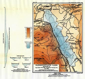 click to enlarge click to enlargeMIL4.jpg - with soundings and sections item:- Kendal Library : 7.3 Image © see bottom of page |
|||||||||||||||||||||||||
|
|
||||||||||||||||||||||||||
| evidence:- | old print:- Heaton Cooper 1905 (edn 1908) placename:- Bassenthwaite Lake item:- boating |
|||||||||||||||||||||||||
| source data:- | Print, colour halftone, Bassenthwaite Lake, a breezy morn, Bassenthwaite, Cumberland,
from a watercolour painting by Alfred Heaton Cooper, published by Adam and Charles
Black, London, 2nd edn 1908.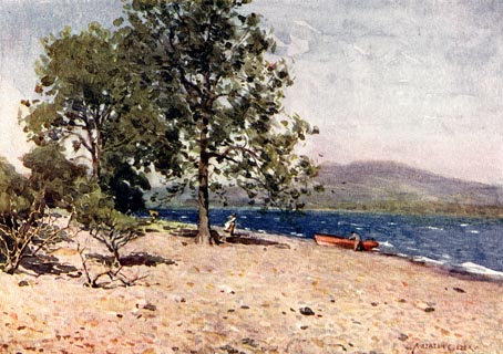 click to enlarge click to enlargeHC0155.jpg Opposite p.160 of The English Lakes, painted by Alfred Heaton Cooper, described by William T Palmer. printed at tissue opposite the print:- "BASSENTHWAITE LAKE / A breezy morn" printed at signed lower right:- "[A HEATON COOPER]" item:- JandMN : 468.55 Image © see bottom of page |
|||||||||||||||||||||||||
|
|
||||||||||||||||||||||||||
| evidence:- | illustration:- LNWR 1910 |
|||||||||||||||||||||||||
| source data:- | Print, colour lithograph? Bassenthwaite, from Ambleside Road,
near Keswick, from a painting by R T Roussel, published by the
London and North Western Railway, LNWR, about 1910.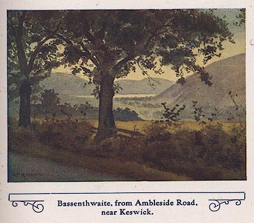 click to enlarge click to enlargeNW01E8.jpg Included in the guide book, The English Lakes, published by the London and North Western Railway about 1910. Roussel, R T, 1910item:- JandMN : 49.9 Image © see bottom of page |
|||||||||||||||||||||||||
|
|
||||||||||||||||||||||||||
| evidence:- | old map:- Postlethwaite 1877 (3rd edn 1913) |
|||||||||||||||||||||||||
| source data:- | Map, uncoloured engraving, Map of the Lake District Mining Field, Westmorland, Cumberland,
Lancashire, scale about 5 miles to 1 inch, by John Postlethwaite, published by W H
Moss and Sons, 13 Lowther Street, Whitehaven, Cumberland, 1877 edn 1913. PST2NY13.jpg  PST2NY22.jpg "BASSENTHWAITE LAKE" lake item:- JandMN : 162.2 Image © see bottom of page |
|||||||||||||||||||||||||
|
|
||||||||||||||||||||||||||
| evidence:- | old map:- Burrow 1920s |
|||||||||||||||||||||||||
| source data:- | Road book, On the Road, Dunlop Pictorial Road Plans, volume V,
strip maps with parts in Westmorland, Cumberland etc, irregular
scale about 1.5 miles to 1 inch, by E J Burrow and Co,
Cheltenham, Gloucestershire, 1920s. EJB3Vg44.jpg  EJB3Vg46.jpg item:- private collection : 17 Image © see bottom of page |
|||||||||||||||||||||||||
|
|
||||||||||||||||||||||||||
| evidence:- | old print:- Pearson 1900s placename:- Bassenthwaite Water |
|||||||||||||||||||||||||
| source data:- | Print, halftone photograph, The Head of Bassenthwaite Water, Bassenthwaite, Cumberland,
published by C Arthur Pearson, Henrietta Street, London, 1900s.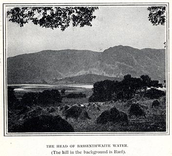 click to enlarge click to enlargePS1E69.jpg On p.194 of Pearson's Gossipy Guide to the English Lakes and Neighbouring Districts. printed at bottom:- "THE HEAD OF BASSENTHWAITE WATER. / (The hill in the background is Barf)." item:- Armitt Library : A1188.76 Image © see bottom of page |
|||||||||||||||||||||||||
|
|
||||||||||||||||||||||||||
| evidence:- | old print:- Gresham Publishing 1900s placename:- Bassenthwaite Lake |
|||||||||||||||||||||||||
| source data:- | Print, colour halftone, Bassenthwaite Lake and Skiddaw, Cumberland, by Ernest W Haslehurst,
published by The Gresham Publishing Co, 66 Chandos Street, London, 1900s?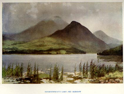 click to enlarge click to enlargePR1566.jpg Tipped in opposite p.36 of The English Lakes section of a volume of Our Beautiful Homeland. printed at bottom:- "BASSENTHWAITE LAKE AND SKIDDAW" printed at lower left:- "E. W. HASLEHURST" item:- JandMN : 381.8 Image © see bottom of page |
|||||||||||||||||||||||||
|
|
||||||||||||||||||||||||||
| evidence:- | outline view:- Matthew 1866 placename:- Bassenthwaite Lake |
|||||||||||||||||||||||||
| source data:- | Print, engraving, outline view, View from Watendlath Road of Derwent Water and Bassenthwaite,
Cumberland, published by J Richardson, Highgate, Kendal, Westmorland, 1866.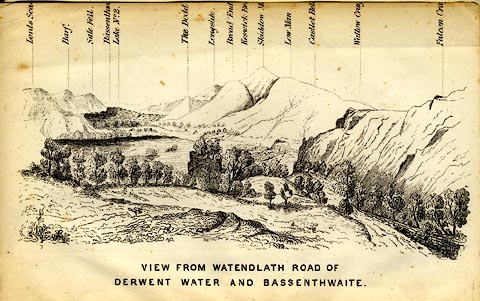 click to enlarge click to enlargeMW1E05.jpg Tipped in before p.1 of The English Lakes, Peaks and Passes, from Kendal to Keswick, by George King Matthew. printed at bottom:- "VIEW FROM WATENDLATH ROAD OF / DERWENT WATER AND BASSENTHWAITE." printed at caption to mountains:- "... Bassenthw[ ] Lake ..." item:- Armitt Library : A1168.5 Image © see bottom of page |
|||||||||||||||||||||||||
|
|
||||||||||||||||||||||||||
| evidence:- | old drawing:- |
|||||||||||||||||||||||||
| source data:- | Drawing, Bassenthwaite Lake etc, Cumberland, by James Walker Bough, about 1850.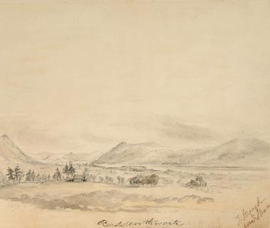 click to enlarge click to enlargePR1367.jpg View south west showing trees and buildings in the foreground. Bassenthwaite lake in the centre with hills to the left, the far distant shore and beyond Keswick. inscribed &signed at bottom, bottom right, top right:- "Bassenthwaite, J Bough brother S Bough, 40" item:- Tullie House Museum : 2006.55 Image © Tullie House Museum |
|||||||||||||||||||||||||
|
|
||||||||||||||||||||||||||
| evidence:- | old print:- Sylvan 1847 placename:- Bassenthwaite Lake |
|||||||||||||||||||||||||
| source data:- | Print, engraving, Bassenthwaite Lake, Cumberland, published by John Johnstone, Paternoster
Row, London, et al, 1847.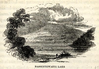 click to enlarge click to enlargeSYL142.jpg On p.179 of Sylvan's Pictorial Guide to the English Lakes. printed at bottom:- "BASSENTHWAITE LAKE." item:- Armitt Library : A1201.42 Image © see bottom of page |
|||||||||||||||||||||||||
|
|
||||||||||||||||||||||||||
| evidence:- | outline view:- Tattersall 1836 (version 1869) placename:- Bassenthwaite Lake |
|||||||||||||||||||||||||
| source data:- | Print, hand coloured, Derwentwater and Bassenthwaite Lakes, from the road to Watendlath,
Cumberland, drawn by George Tattersall, 1836, engraved by W F Topham, published by
T J Allman, 463 Oxford Street, London, 1869.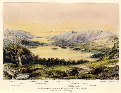 click to enlarge click to enlargeTAT212.jpg Included in The Lakes of England, by W F Topham. printed at bottom:- "DERWENTWATER and BASSENTHWAITE LAKES, / from the road to Watendlath." printed at bottom:- "Swinside. / Lord's Seat. / Barff. / St. Herbert's I. / Bassenthwaite L. / Ramps I. / Vicar's I. / Lord's I. / Skiddaw Dodd. / Castle Hill. / Keswick. / Skiddaw. / Latrigg. / Falcon Crag." item:- Armitt Library : A1067.12 Image © see bottom of page |
|||||||||||||||||||||||||
|
|
||||||||||||||||||||||||||
| evidence:- | old print:- Green 1819 placename:- Bassenthwaite Water |
|||||||||||||||||||||||||
| source data:- | Print, aquatint, Bassenthwaite Water, Cumberland, by William Green, 1819, published
by R Lough and Co, Chronicle Office, Finkle Street, Kendal, and others, 1820.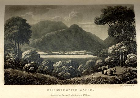 click to enlarge click to enlargeGN0122.jpg Tipped in opposite vol.2 p.120 of The Tourist's New Guide, by William Green. printed at bottom right, centre:- "Vol.2, page 120, line 21. / BASSENTHWAITE WATER. / Published at Ambleside, Augt. 1. 1819, by Wm. Green." item:- Armitt Library : A1141.23 Image © see bottom of page |
|||||||||||||||||||||||||
|
|
||||||||||||||||||||||||||
| evidence:- | old drawing:- placename:- Bassenthwaite Water |
|||||||||||||||||||||||||
| source data:- | Drawing, Bassenthwaite Water, Cumberland, by William Havell, 1800s-10s.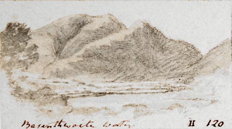 click to enlarge click to enlargePR1404.jpg View of Bassenthwaite Water with large hills in background. One of a set of twenty views of the lake district executed by the artist on one sheet of paper. at bottom:- "Bassenthwaite Water II 120" item:- Tullie House Museum : 2009.89.48 Image © Tullie House Museum |
|||||||||||||||||||||||||
|
|
||||||||||||||||||||||||||
| evidence:- | old print:- |
|||||||||||||||||||||||||
| source data:- | Print, colour lithograph? Bassenthwaite Lake, Cumberland, perhaps published by John
Walker and Co, Farringdon Street, London, late 19th century.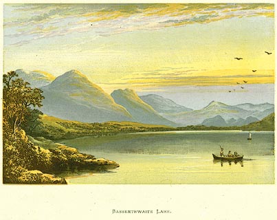 click to enlarge click to enlargePR0135.jpg item:- Dove Cottage : 2008.107.135 Image © see bottom of page |
|||||||||||||||||||||||||
|
|
||||||||||||||||||||||||||
| evidence:- | outline view:- Jenkinson 1875 placename:- Bassenthwaite Lake |
|||||||||||||||||||||||||
| source data:- | Print, lithograph, outline view, Panoramic Sketches from Helvellyn, Westmorland, by
Edwin A Pettitt, London, published by Edward Stanford, 55 Charing Cross, London, 1875.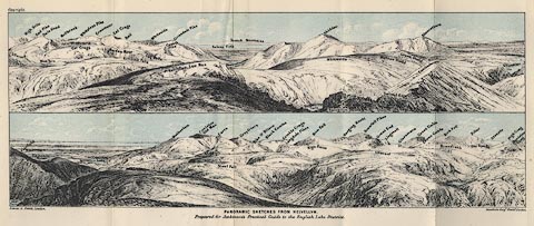 click to enlarge click to enlargeJk01E1.jpg "... Bassenthwaite L. ..." item:- JandMN : 28.5 Image © see bottom of page |
|||||||||||||||||||||||||
|
|
||||||||||||||||||||||||||
| evidence:- | outline view:- Jenkinson 1875 placename:- Bassenthwaite Lake |
|||||||||||||||||||||||||
| source data:- | Print, lithograph, outline view, Panoramic Sketches from Skiddaw, Cumberland, by Edwin
A Pettitt, London, published by Edward Stanford, 55 Charing Cross, London, 1875.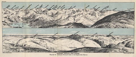 click to enlarge click to enlargeJk01E2.jpg "... Bassenthwaite Lake ..." item:- JandMN : 28.8 Image © see bottom of page |
|||||||||||||||||||||||||
|
|
||||||||||||||||||||||||||
| evidence:- | old print:- Nelson 1859 placename:- Bassenthwaite Lake |
|||||||||||||||||||||||||
| source data:- | Print, engraving, Bassenthwaite Lake and Skiddaw, drawn by Keeley Halswelle, Edinburgh,
published by T Nelson and Sons, Paternoster Row, London, and Edinburgh and New York,
United States, 1859.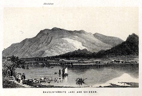 click to enlarge click to enlargeNS0101.jpg Tipped in oppposite p.22 of a guide book, The English Lakes. printed at bottom:- "BASSENTHWAITE LAKE AND SKIDDAW." item:- JandMN : 336.3 Image © see bottom of page |
|||||||||||||||||||||||||
|
|
||||||||||||||||||||||||||
| evidence:- | old print:- Pyne 1853 placename:- Bassenthwaite Lake |
|||||||||||||||||||||||||
| source data:- | Drawn by James Barker Pyne, 1848-1853, lithographed by T Picken, 1859.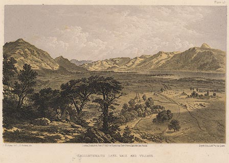 click to enlarge click to enlargePY23.jpg "Bassenthwaite Lake, Vale and Village" item:- JandMN : 97.20 Image © see bottom of page |
|||||||||||||||||||||||||
|
|
||||||||||||||||||||||||||
| evidence:- | old print:- Garnett 1850s-60s F placename:- Bassenthwaite Lake |
|||||||||||||||||||||||||
| source data:- | Print, uncoloured engraving, Bassenthwaite Lake, Cumberland, engraved by William Banks
and Son, Edinburgh, probably published by John Garnett, Windermere, Westmorland, 1850s-60s? click to enlarge click to enlargeGAR725.jpg Found with Views of the English Lakes. printed at bottom:- "Drawn & Eng'd by W. Banks &Son, Edinr. / BASSENTHWAITE LAKE." item:- JandMN : 165.25 Image © see bottom of page |
|||||||||||||||||||||||||
|
|
||||||||||||||||||||||||||
| evidence:- | old print:- Harwood 1842 placename:- Bassenthwaite Water |
|||||||||||||||||||||||||
| source data:- | Print, uncoloured engraving, Skiddaw and Bassenthwaite Water, Cumberland, engraved
and published by John Harwood, 26 Fenchurch Street, London, 1845.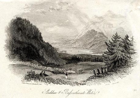 click to enlarge click to enlargePR0553.jpg Included in Harwoods Illustrations of the Lakes. printed at bottom left, right, centre:- "London, J. Harwood, 26, Fenchurch Street. / No.597 June 1. 1845. / Skiddaw and Bassenthwaite Water." item:- Dove Cottage : 2008.107.503 Image © see bottom of page |
|||||||||||||||||||||||||
|
|
||||||||||||||||||||||||||
| evidence:- | old print:- Harwood 1842 placename:- Bassenthwaite Water |
|||||||||||||||||||||||||
| source data:- | Print, uncoloured engraving, Skiddaw and Bassenthwaite Water, Cumberland, engraved
and published by John Harwood, 26 Fenchurch Street, London, 1845.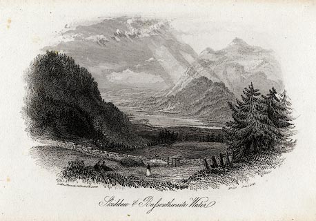 click to enlarge click to enlargeHRW214.jpg printed at bottom left, right, centre:- "London, J. Harwood, 26, Fenchurch Street. / No.597 June 1. 1845. / Skiddaw and Bassenthwaite Water." item:- JandMN : 166.14 Image © see bottom of page |
|||||||||||||||||||||||||
|
|
||||||||||||||||||||||||||
| evidence:- | outline view:- placename:- Bassenthwaite Lake |
|||||||||||||||||||||||||
| source data:- | Print, uncoloured engraving, Derwentwater and Bassenthwaite Lakes from the Road to
Watendlath, Cumberland, published by Sherwood and Co, London, 1836?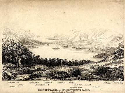 click to enlarge click to enlargePR0370.jpg The view is from just above Ashness Bridge. Objects in the view are identified by a caption at the bottom (unfortunately the print is pale, so some objects are unclear, and the caption seems to be a little misaligned) - Swinside, Lord's Seat, Barff, St. Herbert's I., Bassenthwaite L., Ramp's I., Vicar's I., Lord's I., Skiddaw Dodd, Castle Hill, Keswick, Skiddaw, Latrigg, Falcon Crag. printed at bottom:- "DERWENTWATER and BASSENTHWAITE LAKES. / from the Road to Watendlath." item:- Dove Cottage : 2008.107.370 Image © see bottom of page |
|||||||||||||||||||||||||
|
|
||||||||||||||||||||||||||
| evidence:- | old print:- Rose 1832-35 (vol.3 no.60) placename:- Bassenthwaite Lake |
|||||||||||||||||||||||||
| source data:- | Print, uncoloured engraving, Bassenthwaite Lake Looking South, Cumberland, drawn by
Thomas Allom, engraved by J Phelps, published by Fisher, Son and Co, London, 1832-35.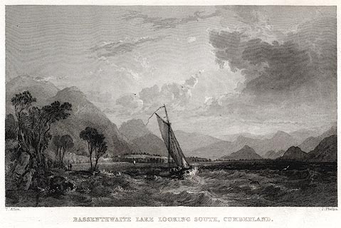 click to enlarge click to enlargePR0052.jpg vol.3 pl.60 in the set of prints, Westmorland, Cumberland, Durham and Northumberland Illustrated. printed at bottom left, right, centre:- "T. Allom. / J. Phelps. / BASSENTHWAITE LAKE LOOKING SOUTH, CUMBERLAND." item:- Dove Cottage : 2008.107.52 Image © see bottom of page |
|||||||||||||||||||||||||
|
|
||||||||||||||||||||||||||
| evidence:- | old print:- Rose 1832-35 (vol.3 no.29) placename:- Bassenthwaite Lake |
|||||||||||||||||||||||||
| source data:- | Print, uncoloured engraving, Derwent and Bassenthwaite Lakes, Keswick and Skiddaw
in the Distance, Cumberland, drawn by G Pickering, engraved by A le Petit, published
by Fisher, Son and Co, London, 1835.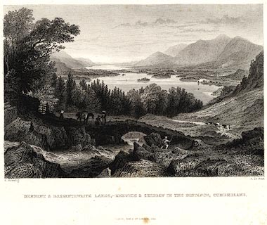 click to enlarge click to enlargePR0041.jpg vol.3 pl.29 in the set of prints, Westmorland, Cumberland, Durham and Northumberland Illustrated. printed at bottom left, right, centre:- ". Pickering. / A. Le Petit. / DERWENT & BASSENTHWAITE LAKES,- KESWICK & SKIDDAW IN THE DISTANCE. / FISHER, SON &CO. LONDON, 1835." item:- Dove Cottage : 2008.107.41 Image © see bottom of page |
|||||||||||||||||||||||||
|
|
||||||||||||||||||||||||||
| evidence:- | old print:- |
|||||||||||||||||||||||||
| source data:- | Print, uncoloured engraving, Distant View of Skiddaw, Cumberland, drawn by P Dewint,
engraved by E Finden, published by Charles Tilt, 86 Fleet Street, London, 1830.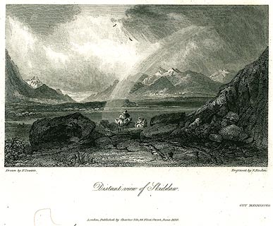 click to enlarge click to enlargePR0275.jpg printed at bottom left, right, centre:- "Drawn by P. Dewint. / Engraved by E. Finden. / Distant View of Skiddaw. / London. Published by Charles Tilt, 86, Fleet Street, June 1830." item:- Dove Cottage : 2008.107.275 Image © see bottom of page |
|||||||||||||||||||||||||
|
|
||||||||||||||||||||||||||
| evidence:- | old print:- Housman 1800 placename:- Bassenthwaite Lake |
|||||||||||||||||||||||||
| source data:- | Print, uncoloured engraving, Bassenthwaite Lake, from Armathwaite, drawn by IW, engraved
by R Scott, published by F Jollie, Carlisle, Cumberland, 1800.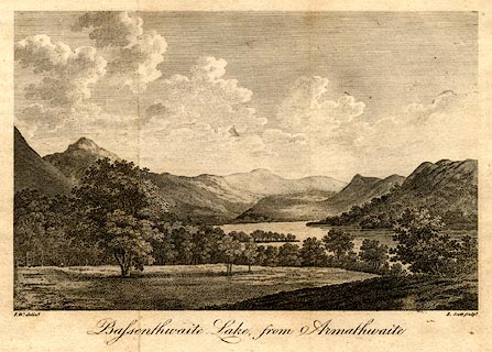 click to enlarge click to enlargePR0475.jpg Taken from a guide book, A Descriptive Tour, and Guide to the Lakes, Caves and Mountains, by John Housman, 1800, 5th edn 1812. printed at bottom left, right, centre:- "I.W. delint. / R. Scott sculpt. / Bassenthwaite Lake, from Armathwaite" item:- JandMN : 233.8 Image © see bottom of page |
|||||||||||||||||||||||||
|
|
||||||||||||||||||||||||||
 BLM54.jpg From the Whinlatter Pass road. (taken 25.12.2005)  BPW07.jpg From about Ullock Pike. (taken 17.12.2008)  Click to enlarge BTQ58.jpg From Fell End.. (taken 5.10.2010) 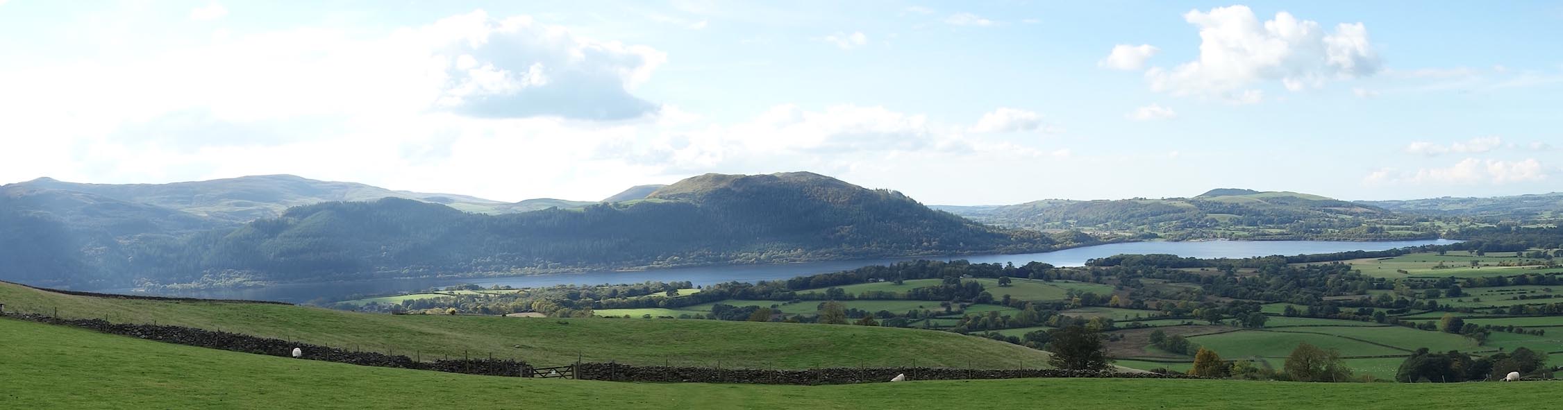 Click to enlarge CEB84.jpg (taken 13.10.2015) |
||||||||||||||||||||||||||
|
|
||||||||||||||||||||||||||
| hearsay:- |
Water horse racing was held at Ouse Bridge. Horses were taken out into the lake by
barge, the first horse to swim ashore was the winner. |
|||||||||||||||||||||||||
|
|
||||||||||||||||||||||||||
| hearsay:- |
Alfred Lord Tennyson is said to have written his poem, Morte d'Arthur, while sitting
by the lake, perhaps near St Bega's Church. In this Sir Bedivere throws Excalibur
into a mere:- |
|||||||||||||||||||||||||
| "So flash'd and fell the brand Excalibur: But erer he dipt the surface, rose an arm Clothed in white samite, mystic, wonderful, And caught him by the hilt, and brandish'd him Three times, and drew him under in the mere." |
||||||||||||||||||||||||||
|
|
||||||||||||||||||||||||||
| see:- | viewpoint, Armathwaite Hall Thomas West I viewpoint, Bassenthwaite Common Jonathan Otley viewpoint, Beck Wythop Thomas West IV viewpoint, Broadness Thomas West III viewpoint, Long Close Peter Crosthwaite I viewpoint, Ouse Bridge Inn Peter Crosthwaite III viewpoint, Rakes Thomas West viewpoint, Sandbeds Gill Peter Crosthwaite II viewpoint, Scarness Thomas West II |
|||||||||||||||||||||||||
|
|
||||||||||||||||||||||||||
Lakes Guides menu.