 Old Cumbria Gazetteer
 |
 |
|
||||||||||||||||||||||||
| Grasmoor, Buttermere | ||||||||||||||||||||||||||
| Grasmoor | ||||||||||||||||||||||||||
| civil parish:- | Buttermere (formerly Cumberland) | |||||||||||||||||||||||||
| county:- | Cumbria | |||||||||||||||||||||||||
| locality type:- | hill | |||||||||||||||||||||||||
| coordinates:- | NY17492034 | |||||||||||||||||||||||||
| 1Km square:- | NY1720 | |||||||||||||||||||||||||
| 10Km square:- | NY12 | |||||||||||||||||||||||||
| altitude:- | 2791 feet | |||||||||||||||||||||||||
| altitude:- | 851m | |||||||||||||||||||||||||
|
|
||||||||||||||||||||||||||
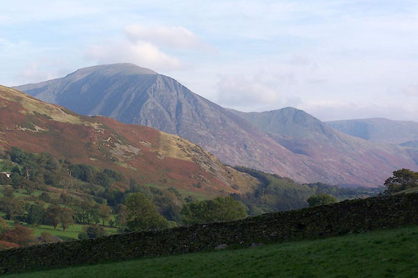
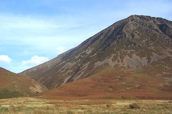 BJY19.jpg From Lanthwaite. (taken 14.10.2005) 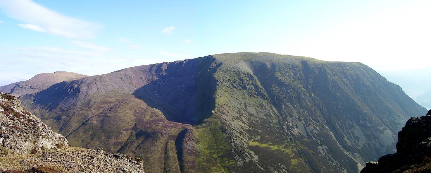 Click to enlarge BNK97.jpg (taken 24.3.2007) |
||||||||||||||||||||||||||
|
|
||||||||||||||||||||||||||
| evidence:- | old map:- OS County Series (Cmd 63 14) placename:- Grasmoor |
|||||||||||||||||||||||||
| source data:- | Maps, County Series maps of Great Britain, scales 6 and 25
inches to 1 mile, published by the Ordnance Survey, Southampton,
Hampshire, from about 1863 to 1948. |
|||||||||||||||||||||||||
|
|
||||||||||||||||||||||||||
| evidence:- | old map:- Gents Mag 1751 placename:- Grasmire |
|||||||||||||||||||||||||
| source data:- | Map, uncoloured engraving, Map of the Black Lead Mines in
Cumberland, and area, scale about 2 miles to 1 inch, by George
Smith, published in the Gentleman's Magazine, 1751.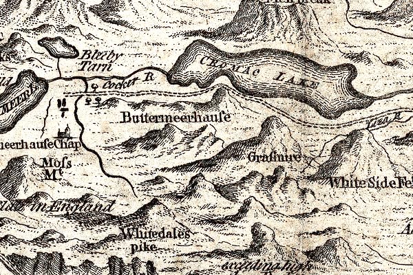 GM1306.jpg "Grasmire" knobbly hillocks; mountains item:- JandMN : 114 Image © see bottom of page |
|||||||||||||||||||||||||
|
|
||||||||||||||||||||||||||
| evidence:- | old map:- Donald 1774 (Cmd) placename:- Grassmire |
|||||||||||||||||||||||||
| source data:- | Map, hand coloured engraving, 3x2 sheets, The County of Cumberland, scale about 1
inch to 1 mile, by Thomas Donald, engraved and published by Joseph Hodskinson, 29
Arundel Street, Strand, London, 1774.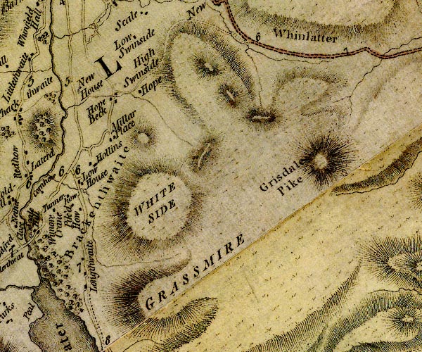 D4NY12SE.jpg "GRASSMIRE" hill hachuring; a hill or mountain item:- Carlisle Library : Map 2 Image © Carlisle Library |
|||||||||||||||||||||||||
|
|
||||||||||||||||||||||||||
| evidence:- | descriptive text:- West 1778 (11th edn 1821) placename:- Grasmire |
|||||||||||||||||||||||||
| source data:- | Guide book, A Guide to the Lakes, by Thomas West, published by
William Pennington, Kendal, Cumbria once Westmorland, and in
London, 1778 to 1821. goto source goto sourcePage 142:- "... Behind you, awful Grasmire (the Skiddaw of the vale) frowns in all the majesty of furrowed rock, cut almost perpendicularly to the centre by the water-falls of ages." "... ..." goto sourcePage 190:- "A TABLE OF THE Height of Mountains and Lakes SEEN IN THIS TOUR, ... TAKEN FROM THE LEVEL OF THE SEA. ... by Mr. John Dalton." "Grasmire, N.E. of Crummock Lake ... 955 [yards]" |
|||||||||||||||||||||||||
|
|
||||||||||||||||||||||||||
| evidence:- | old map:- West 1784 map placename:- Grasmire Hill |
|||||||||||||||||||||||||
| source data:- | Map, hand coloured engraving, A Map of the Lakes in Cumberland,
Westmorland and Lancashire, scale about 3.5 miles to 1 inch,
engraved by Paas, 53 Holborn, London, about 1784.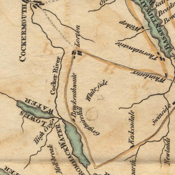 Ws02NY12.jpg Shown by a small circle of hachuring. item:- Armitt Library : A1221.1 Image © see bottom of page |
|||||||||||||||||||||||||
|
|
||||||||||||||||||||||||||
| evidence:- | old print:- Green 1804 (plate 20) placename:- Grasmire |
|||||||||||||||||||||||||
| source data:- | Print, uncoloured aquatint, Lowes Water, distance Grasmire, Loweswater, Cumberland,
by William Green, Ambleside, Westmorland, 1804.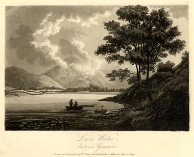 click to enlarge click to enlargeGN1620.jpg Plate 20 from a series. printed at bottom:- "Lowes Water, / distance Grasmire. / Drawn and Engraved by Wm. Green, and Published at Ambleside, June 24, 1804." printed at top right:- "20" at :- "W ELGAR / 1802" item:- Armitt Library : 2014.168 Image © see bottom of page |
|||||||||||||||||||||||||
|
|
||||||||||||||||||||||||||
| evidence:- | old text:- Green 1814 placename:- Grasmire |
|||||||||||||||||||||||||
| source data:- | Set of prints, soft ground etchings, Sixty Small Prints, with
text, A Description of a Series of Sixty Small Prints, by
William Green, Ambleside, Westmorland, 1814. goto source page 22:- "..." "Melbreak, Whiteside, Grasmire, Rannerdale Knott, and Honister Crag are fine objects when seen from the head of Low's Water. ..." |
|||||||||||||||||||||||||
|
|
||||||||||||||||||||||||||
| evidence:- | old map:- Otley 1818 placename:- Grasmoor |
|||||||||||||||||||||||||
| source data:- | Map, uncoloured engraving, The District of the Lakes,
Cumberland, Westmorland, and Lancashire, scale about 4 miles to
1 inch, by Jonathan Otley, 1818, engraved by J and G Menzies,
Edinburgh, Scotland, published by Jonathan Otley, Keswick,
Cumberland, et al, 1833.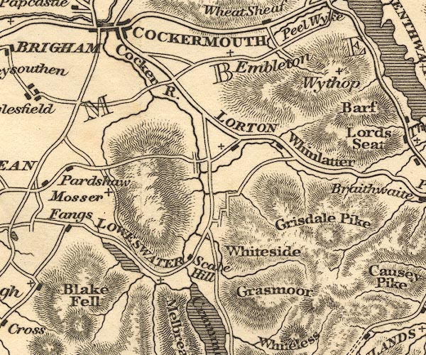 OT02NY12.jpg item:- JandMN : 48.1 Image © see bottom of page |
|||||||||||||||||||||||||
|
|
||||||||||||||||||||||||||
| evidence:- | outline view:- Otley 1823 (4th edn 1830) placename:- Grasmoor |
|||||||||||||||||||||||||
| source data:- | Print, engraving, outline view, Some of the Western Mountains as seen from Helvellyn,
published by Jonathan Otley, Keswick, Cumberland et al, 1830.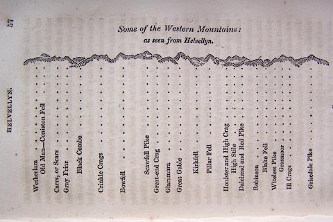 click to enlarge click to enlargeO75E02.jpg p.57 in A Concise Description of the English Lakes, by Jonathan Otley, 4th edition, 1830. "Some of the Western Mountains: / as seen from Helvellyn." "Wetherlam / Old Man - Coniston Fell / Carrs, or Scars / Gray Friar / Black Combe / Crinkle Crags / Bowfell / Scawfell Pike / Great-end Crag / Glaramara / Great Gable / Kirkfell / Pillar Fell / Honister and High Crag / High Stile / Dalehead and Red Pike / Robinson / Blake Fell / Witeless Pike / Grasmoor / Ill Crags / Grisedale Pike" item:- Armitt Library : A1175.3 Image © see bottom of page |
|||||||||||||||||||||||||
|
|
||||||||||||||||||||||||||
| evidence:- | outline view:- Otley 1823 (4th edn 1830) placename:- Grasmoor |
|||||||||||||||||||||||||
| source data:- | Print, engraving, outline view, The Mountains of Crummock and Buttermere as seen on
the Road between Scale-Hill and Loweswater, published by Jonathan Otley, Keswick,
Cumberland et al, 1830.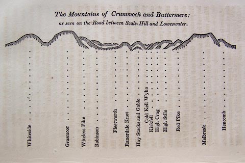 click to enlarge click to enlargeO75E07.jpg p.125 in A Concise Description of the English Lakes, by Jonathan Otley, 4th edition, 1830. "The Mountains of Crummock and Buttermere: / as seen on the Road between Scale-Hill and Loweswater." "Whiteside / Grasmoor / Witeless Pike / Robinson / Fleetworth / Rannerdale Knot / Hay Stacks and Gable / Cold Kell Wyke / Kirkfell / High Crag / High Stile / Red Pike / Melbreak / Hencomb" item:- Armitt Library : A1175.7 Image © see bottom of page |
|||||||||||||||||||||||||
|
|
||||||||||||||||||||||||||
| evidence:- | outline view:- Otley 1823 (8th edn 1849) placename:- Grasmoor |
|||||||||||||||||||||||||
| source data:- | Engraving, outline view of mountains, Crummock and Buttermere from the Road near Loweswater
Church, drawn by T Binns, engraved by O Jewitt, opposite p.18 of A Descriptive Guide
of the English Lakes, by Jonathan Otley, 8th edition, 1849.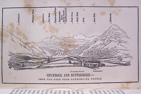 click to enlarge click to enlargeO80E10.jpg item:- Armitt Library : A1180.11 Image © see bottom of page |
|||||||||||||||||||||||||
|
|
||||||||||||||||||||||||||
| evidence:- | outline view:- Otley 1823 (8th edn 1849) placename:- Grasmoor |
|||||||||||||||||||||||||
| source data:- | Engraving, outline view of mountains, A Group of Mountains seen from Helvellyn, looking
towards the South West, drawn by T Binns, engraved by O Jewitt, opposite p.50 of A
Descriptive Guide of the English Lakes, by Jonathan Otley, 8th edition, 1849.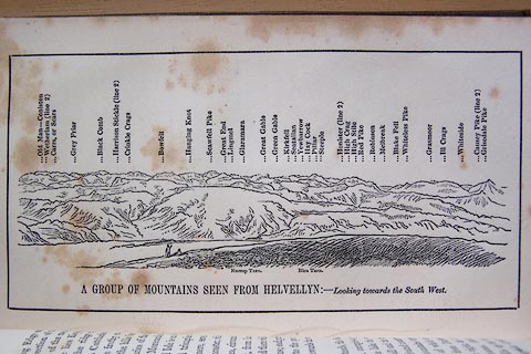 click to enlarge click to enlargeO80E17.jpg item:- Armitt Library : A1180.18 Image © see bottom of page |
|||||||||||||||||||||||||
|
|
||||||||||||||||||||||||||
| evidence:- | outline view:- Otley 1823 (5th edn 1834) |
|||||||||||||||||||||||||
| source data:- | Print, woodcut outline view, The Mountains of Crummock and
Buttermere, by Jonathan Otley, Keswick, Cumberland, 1830.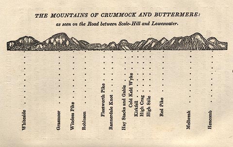 click to enlarge click to enlargeOT2E05.jpg Printed on p.25 of A Concise Description of the English Lakes, by Jonathan Otley, 5th edition, 1834. "THE MOUNTAINS OF CRUMMOCK AND BUTTERMERE: as seen on the Road between Scale-Hill and Loweswater." "Whiteside / Grasmoor / Witeless Pike / Robinson / Fleetworth Pike / Rannerdale Knot / Hay Stacks and Gable / Cold Keld Wyke / Kirkfell / High Crag / High Stile / Red Pike / Melbreak / Hencomb" item:- JandMN : 48.6 Image © see bottom of page |
|||||||||||||||||||||||||
|
|
||||||||||||||||||||||||||
| evidence:- | outline view:- Otley 1823 (5th edn 1834) |
|||||||||||||||||||||||||
| source data:- | Print, woodcut outline view, A Group of Mountains, seen from
Helvellyn, by Jonathan Otley, Keswick, Cumberland, 1830.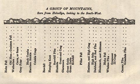 click to enlarge click to enlargeOT2E09.jpg Printed on p.63 of A Concise Description of the English Lakes, by Jonathan Otley, 5th edition, 1834. "A GROUP OF MOUNTAINS, Seen from Helvellyn, looking to the South-West." "Holm Fell / Old Man - Coniston Fell / Wetherlam / Carrs, or Scars / Gray Friar / Black Combe / Harrison Stickle / Crinkle Crags / Bowfell / Hanging Knot / Scawfell Pike / Hindside / Great-end Crag / Glaramara / Great Gable / Green Gable / Kirkfell / Pillar Fell / Honister, and High Crag / High Stile / Dalehead, and Red Pike / Hindscarth, and Robinson / Blake Fell / Witeless Pike / Grasmoor / Ill Crags / Causey Pike / Grisedale Pike" item:- JandMN : 48.10 Image © see bottom of page |
|||||||||||||||||||||||||
|
|
||||||||||||||||||||||||||
| evidence:- | descriptive text:- Otley 1823 (5th edn 1834) item:- geology |
|||||||||||||||||||||||||
| source data:- | Guide book, A Concise Description of the English Lakes, the
mountains in their vicinity, and the roads by which they may be
visited, with remarks on the mineralogy and geology of the
district, by Jonathan Otley, published by the author, Keswick,
Cumberland now Cumbria, by J Richardson, London, and by Arthur
Foster, Kirkby Lonsdale, Cumbria, 1823; published 1823-49,
latterly as the Descriptive Guide to the English Lakes. goto source Page 71:- "GRASMOOR" "Is a bold rocky mountain on the eastern side of Crummock Lake; it is sometimes called Grasmire, a name in no wise corresponding with its appearance. It rises to the height of 2756 feet. The side towards the lake is extremely rocky and barren; but the eastern side is a grassy slope, and on its summit is a plain of several acres; it affords a good bird's eye view of the Lakes of Buttermere, Crummock and Loweswater, with their adjacent mountains; and a considerable portion of the Cumberland and Scottish coasts." "..." goto sourcePage 152:- "The greatest bulk of these mountain rocks have been commonly included under the general appellation of slate; although many of them shew no disposition to the slaty cleavage. They may be classed in three principal divisions." "Of these divisions, the FIRST or lowest in the series, forms ... Grasmoor, ..." "..." |
|||||||||||||||||||||||||
|
|
||||||||||||||||||||||||||
| evidence:- | descriptive text:- Ford 1839 (3rd edn 1843) placename:- Grasmoor item:- altitude, Grasmoor |
|||||||||||||||||||||||||
| source data:- | Guide book, A Description of Scenery in the Lake District, by
Rev William Ford, published by Charles Thurnam, Carlisle, by W
Edwards, 12 Ave Maria Lane, Charles Tilt, Fleet Street, William
Smith, 113 Fleet Street, London, by Currie and Bowman,
Newcastle, by Bancks and Co, Manchester, by Oliver and Boyd,
Edinburgh, and by Sinclair, Dumfries, 1839. goto source "... THE Lake district ... consists of large masses or clusters of mountains, generally terminating in one aspiring and pre-eminent point, with the intermediate valleys occupied either by lakes and their subsidiary tarns, or by winding rivers." "The chief nuclei of these clusters are, Skiddaw and Blencathra, Helvellyn, Fairfield, Coniston Old Man, Blackcomb, Scafell, Gable, Red Pike, Grasmoor, Grisdale Pike, and the Langdale Pikes. Many noble and commanding mountains rise around these, rivalling them in height and grandeur, but still" goto sourcePage iv:- "serving as large buttresses only. In the presentation of endlessly-diversified forms, these Mountains yield to none, however individually inferior they may be, owing to their being seldom seen in a detached point of view; although, on the other hand, they have thus the advantage of forming combinations at once grand and sublime, towering above each other, or rising in ridges, like the mighty billows of the ocean." goto sourcePage 178:- "ELEVATION OF THE MOUNTAINS," "ACCORDING TO DIFFERENT AUTHORITIES."
|
|||||||||||||||||||||||||
|
|
||||||||||||||||||||||||||
| evidence:- | old map:- Ford 1839 map placename:- Grassmoor |
|||||||||||||||||||||||||
| source data:- | Map, uncoloured engraving, Map of the Lake District of
Cumberland, Westmoreland and Lancashire, scale about 3.5 miles
to 1 inch, published by Charles Thurnam, Carlisle, and by R
Groombridge, 5 Paternoster Row, London, 3rd edn 1843. FD02NY12.jpg "Grassmoor" Hill hachuring. item:- JandMN : 100.1 Image © see bottom of page |
|||||||||||||||||||||||||
|
|
||||||||||||||||||||||||||
| evidence:- | old map:- Garnett 1850s-60s H placename:- Grassmoor |
|||||||||||||||||||||||||
| source data:- | Map of the English Lakes, in Cumberland, Westmorland and
Lancashire, scale about 3.5 miles to 1 inch, published by John
Garnett, Windermere, Westmorland, 1850s-60s. GAR2NY11.jpg "Grassmoor" hill hachuring item:- JandMN : 82.1 Image © see bottom of page |
|||||||||||||||||||||||||
|
|
||||||||||||||||||||||||||
| evidence:- | outline view:- Martineau 1855 |
|||||||||||||||||||||||||
| source data:- | Print, engraving, outline view, Mountains seen from Applethwaite near Keswick, drawn
by L Aspland, engraved by W Banks, Edinburgh, published by John Garnett, Windermere,
Westmorland, and by Whittaker and Co, London, 1855.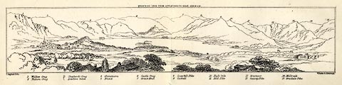 click to enlarge click to enlargeMNU114.jpg Folded in opposite p.93 in A Complete Guide to the English Lakes, by Harriet Martineau. "MOUNTAINS SEEN FROM APPLETHWAITE NEAR KESWICK." "L Aspland Delt. / W Banks Sc Edinr." The view is captioned, numbers referring to mountains in the image:- "1 Wallow Crag, 2 Falcon Crag, 3 Shepherd's Crag / Lowdore below, 4 Glaramara, 5 Brund, 6 Castle Crag, 7 Great End, 8 Scawfell Pike, 9 Catbell, 10, High Stile, 11 Red Pike, 12 Grasmoor, 13 Causey Pike, 14 Melbreak, 15 Grisdale Pike" item:- Armitt Library : A1159.14 Image © see bottom of page |
|||||||||||||||||||||||||
|
|
||||||||||||||||||||||||||
| evidence:- | old text:- Martineau 1855 placename:- Grassmoor item:- altitude, Grasmoor |
|||||||||||||||||||||||||
| source data:- | Guide book, A Complete Guide to the English Lakes, by Harriet
Martineau, published by John Garnett, Windermere, Westmorland,
and by Whittaker and Co, London, 1855; published 1855-76. goto source Page 179:- "A TABLE OF THE HEIGHTS OF MOUNTAINS IN THE COUNTIES OF CUMBERLAND, WESTMORLAND, AND LANCASHIRE." "No. : Names of Mountains. : Counties. : Height in Feet above the Sea Level." "11 : Grassmoor : Cumberland : 2756" |
|||||||||||||||||||||||||
|
|
||||||||||||||||||||||||||
| evidence:- | outline view:- Barrow 1888 placename:- Grassmoor |
|||||||||||||||||||||||||
| source data:- | Outline view, engraving? Outline of Mountain Tops as seen from the Keswick Hotel,
sketched by John Barrow, published by Sampson Low, Marston, Searle, and Rivington,
St Dunstan's House, Fetter Lane, Fleet Street, London, 1888.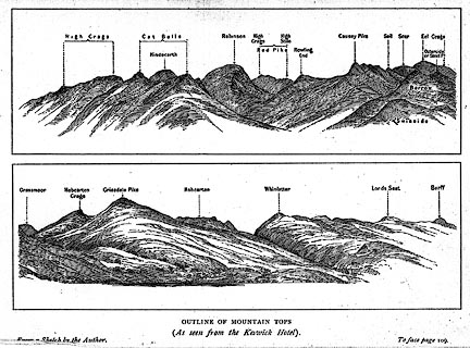 click to enlarge click to enlargeBRW1.jpg "... Grassmoor ..." item:- Kendal Library : 10.3 Image © see bottom of page |
|||||||||||||||||||||||||
|
|
||||||||||||||||||||||||||
| evidence:- | outline view:- Jenkinson 1875 placename:- Grasmoor |
|||||||||||||||||||||||||
| source data:- | Print, lithograph, outline view, Panoramic Sketches from Helvellyn, Westmorland, by
Edwin A Pettitt, London, published by Edward Stanford, 55 Charing Cross, London, 1875.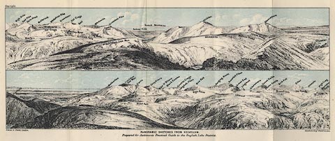 click to enlarge click to enlargeJk01E1.jpg "... Grasmoor ..." item:- JandMN : 28.5 Image © see bottom of page |
|||||||||||||||||||||||||
|
|
||||||||||||||||||||||||||
| evidence:- | outline view:- Jenkinson 1875 placename:- Grasmoor |
|||||||||||||||||||||||||
| source data:- | Print, lithograph, outline view, Panoramic Sketches from Skiddaw, Cumberland, by Edwin
A Pettitt, London, published by Edward Stanford, 55 Charing Cross, London, 1875.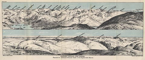 click to enlarge click to enlargeJk01E2.jpg "... Grasmoor ..." item:- JandMN : 28.8 Image © see bottom of page |
|||||||||||||||||||||||||
|
|
||||||||||||||||||||||||||
| evidence:- | outline view:- Jenkinson 1875 placename:- Grasmoor |
|||||||||||||||||||||||||
| source data:- | Print, lithograph, outline view, Panoramic Sketches from Scawfell Pike, Cumberland,
by Edwin A Pettitt, London, published by Edward Stanford, 55 Charing Cross, London,
1875.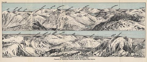 click to enlarge click to enlargeJk01E3.jpg "... Grasmoor ..." item:- JandMN : 28.9 Image © see bottom of page |
|||||||||||||||||||||||||
|
|
||||||||||||||||||||||||||
| evidence:- | outline view:- Black 1856 (23rd edn 1900) placename:- Grasmoor |
|||||||||||||||||||||||||
| source data:- | Print, lithograph, Outline Views, Skiddaw and Derwent Water - Mountains as seen at
Lodore Hotel, and Mountains as seen at the Third Gate on Ascending Latrigg on the
Way to Skiddaw, by J Flintoft, Keswick, Cumberland, engraved by R Mason, Edinburgh,
Lothian, about 1900.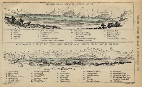 click to enlarge click to enlargeBC08E4.jpg "... 24 Grasmoor ..." item:- JandMN : 37.14 Image © see bottom of page |
|||||||||||||||||||||||||
|
|
||||||||||||||||||||||||||
| evidence:- | outline view:- Black 1856 (23rd edn 1900) placename:- Grasmoor |
|||||||||||||||||||||||||
| source data:- | Print, lithograph, Outline Views, Buttermere - Mountains as seen from the Knots near
the Hotel at Buttermere, and Mountains as seen at the Seat in Lanthwaite Wood, Scale
Hill, by J Flintoft, Keswick, Cumberland, engraved by R Mason, Edinburgh, Lothian,
about 1900.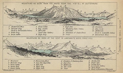 click to enlarge click to enlargeBC08E5.jpg "... 1 Grasmoor ..." item:- JandMN : 37.19 Image © see bottom of page |
|||||||||||||||||||||||||
|
|
||||||||||||||||||||||||||
| evidence:- | outline view:- Black 1841 (3rd edn 1846) placename:- Grasmoor |
|||||||||||||||||||||||||
| source data:- | Print, engraving, outline view, Mountains as seen from The Knots near the Victoria
at Buttermere, and Mountains as seen at the Seat in Lanthwaite Wood, Scale Hill, by
J Flintoft, Keswick, Cumberland, engraved by R Mason, Edinburgh, Lothian, about 1846.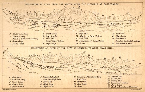 click to enlarge click to enlargeBC02E7.jpg "... 1 Grasmoor ..." item:- JandMN : 32.11 Image © see bottom of page |
|||||||||||||||||||||||||
|
|
||||||||||||||||||||||||||
| evidence:- | outline view:- Black 1841 (3rd edn 1846) placename:- Grasmoor |
|||||||||||||||||||||||||
| source data:- | Print, engraving, outline view, Mountains as seen at Lowdore Inn, and Mountains as
seen at the Third Gate on Ascending Latrigg on the Way to Skiddaw, by J Flintoft,
Keswick, Cumberland, engraved by R Mason, Edinburgh, Lothian, about 1846.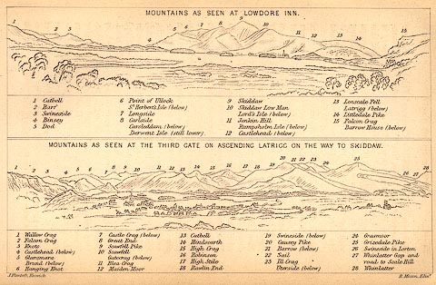 click to enlarge click to enlargeBC02E4.jpg "... 24 Grasmoor ..." item:- JandMN : 32.7 Image © see bottom of page |
|||||||||||||||||||||||||
|
|
||||||||||||||||||||||||||
| evidence:- | outline view:- Tattersall 1836 (version 1869) placename:- Grasmoor |
|||||||||||||||||||||||||
| source data:- | Print, hand coloured, Loweswater, from the North West, Cumberland, drawn by George
Tattersall, 1836, engraved by W F Topham, published by T J Allman, 463 Oxford Street,
London, 1869.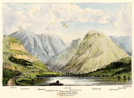 click to enlarge click to enlargeTAT216.jpg Included in The Lakes of England, by W F Topham. printed at bottom:- "LOWESWATER, / from the North West." printed at bottom:- "Bottom. / Grasmoor. / Whiteless. / Buttermere Moss. / Hindscarth. / Low Fell. / Glaramara. / Honister Crag. / Melbreak. / High Style. / Red Pike. / Blake Fell." item:- Armitt Library : A1067.16 Image © see bottom of page |
|||||||||||||||||||||||||
|
|
||||||||||||||||||||||||||
| evidence:- | outline view:- Tattersall 1836 (version 1869) placename:- Grasmoor |
|||||||||||||||||||||||||
| source data:- | Print, hand coloured, Crummock Lake, from the East, Buttermere, Cumberland, drawn
by George Tattersall, 1836, engraved by W F Topham, published by T J Allman, 463 Oxford
Street, London, 1869.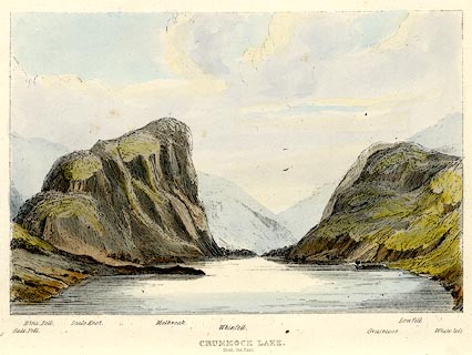 click to enlarge click to enlargeTAT211.jpg Included in The Lakes of England, by W F Topham. printed at bottom:- "CRUMMOCK LAKE, / from the East." printed at bottom:- "Gale Fell. / Blea Fell. / Scale Knot. / Melbreak. / Whinfell. / Grasmoor. / Low Fell. / Whiteless." item:- Armitt Library : A1067.11 Image © see bottom of page |
|||||||||||||||||||||||||
|
|
||||||||||||||||||||||||||
| evidence:- | outline view:- Tattersall 1836 placename:- Grasmoor |
|||||||||||||||||||||||||
| source data:- | Print, engraving, Loweswater from the North West, Cumberland, drawn by George Tattersall,
engraved by W F Topham, published by Sherwood and Co, Paternoster Row, London, about
1836.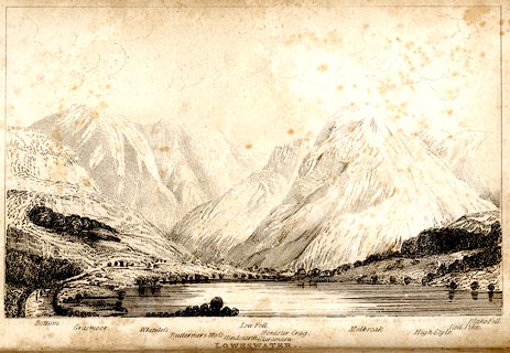 click to enlarge click to enlargeTAT134.jpg The print is captioned with mountain names and acts as an outline view. Frontispiece to The Lakes of England, by George Tattersall (listed to be inserted opposite p.35). printed at bottom:- "LOWESWATER. / from the North West." printed at bottom left to right:- "Bottom. / Grasmoor. / Whiteless. / Buttermere &Moss. / Hindscarth. / Low Fell. / Glaramara. / Honister Crag. / Melbreak. / High Style. / Red Pike. / Blake Fell." item:- Armitt Library : A1204.35 Image © see bottom of page |
|||||||||||||||||||||||||
|
|
||||||||||||||||||||||||||
| evidence:- | outline view:- Tattersall 1836 placename:- Grasmoor |
|||||||||||||||||||||||||
| source data:- | Print, engraving, Crummock Lake, from the East, Buttermere, Cumberland, drawn by George
Tattersall, engraved by W F Topham, published by Sherwood and Co, Paternoster Row,
London, about 1836.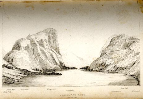 click to enlarge click to enlargeTAT128.jpg The print is captioned with mountain names and acts as an outline view. Tipped in opposite p.74 of The Lakes of England, by George Tattersall. printed at bottom:- "CRUMMOCK LAKE. / from the East." printed at bottom left to right:- "Gale Fell. / Blea Fell. / Scale Knot. / Melbreak. / Whinfell. / Grasmoor. / Lowfell. / Whiteless." item:- Armitt Library : A1204.29 Image © see bottom of page |
|||||||||||||||||||||||||
|
|
||||||||||||||||||||||||||
 BJY12.jpg From the Fangs, roughly. (taken 14.10.2005) 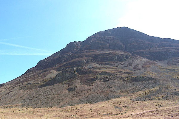 BLY28.jpg (taken 24.4.2006) 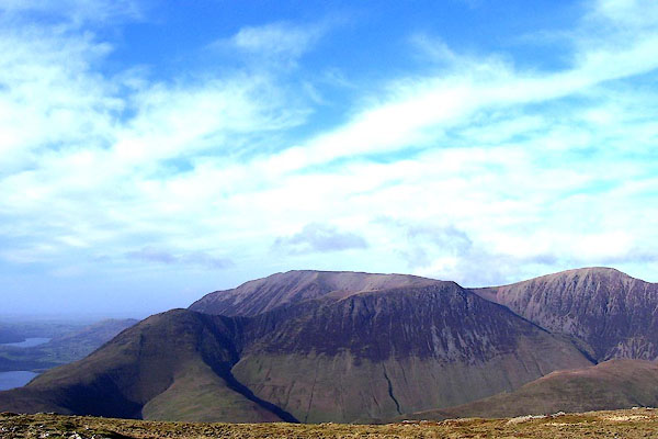 BNE28.jpg Whiteless Pike; Grasmoor and Wandhope; Crag Hill (taken 14.2.2007) 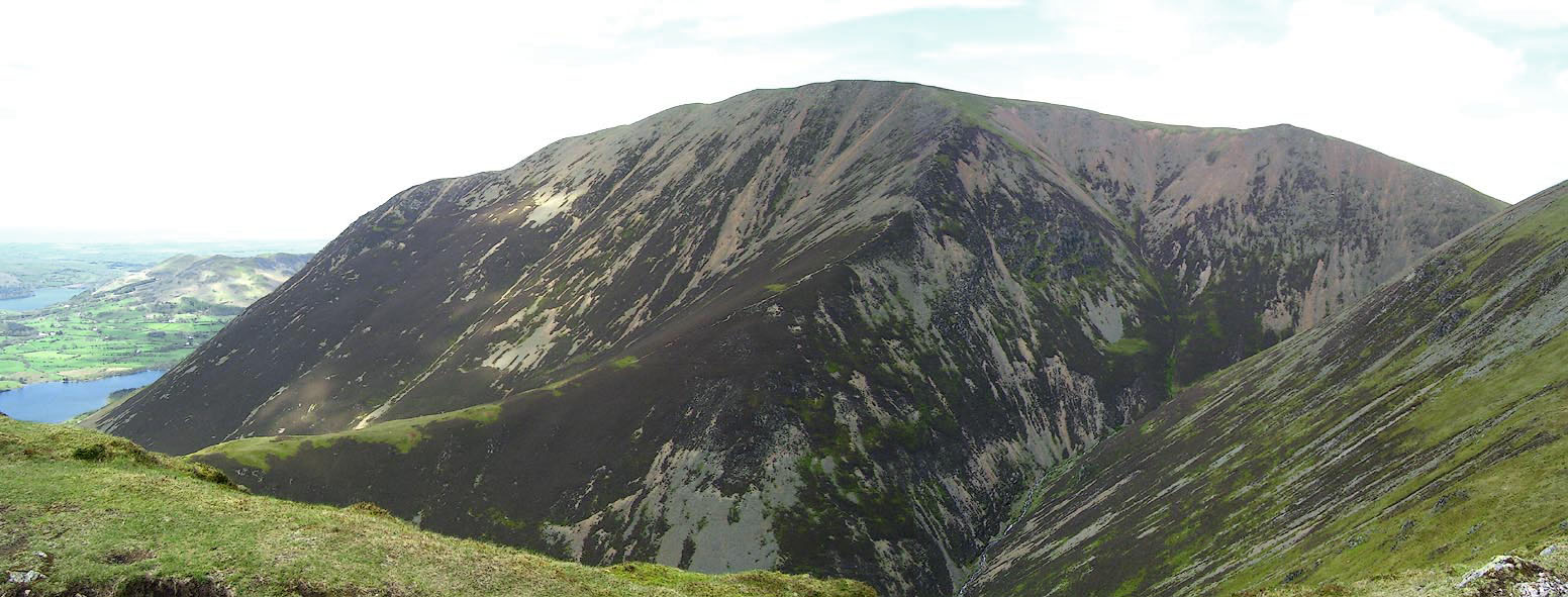 Click to enlarge BNP74.jpg (taken 26.4.2007) 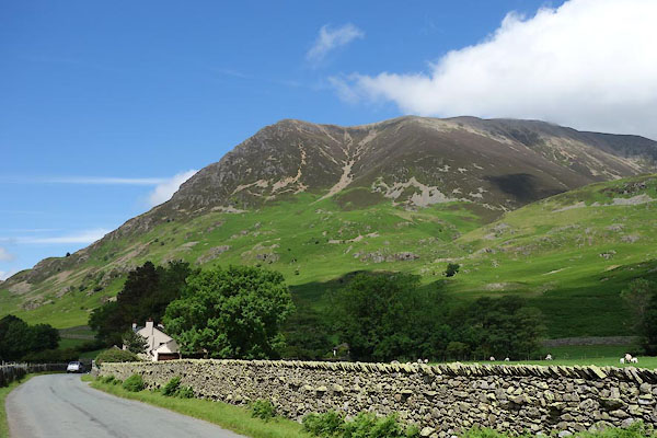 CAY30.jpg (taken 11.6.2014) |
||||||||||||||||||||||||||
|
|
||||||||||||||||||||||||||
Lakes Guides menu.