 Old Cumbria Gazetteer
 |
 |
|
| Dunmail Raise Stones, St John's Castlerigg etc | ||
| Dunmail Raise Stones | ||
| locality:- | Dunmail Raise | |
| civil parish:- | St John's Castlerigg and Wythburn (formerly Cumberland) | |
| county:- | Cumbria | |
| locality type:- | cairn | |
| locality type:- | burial mound | |
| coordinates:- | NY32721172 | |
| 1Km square:- | NY3211 | |
| 10Km square:- | NY31 | |
|
|
||
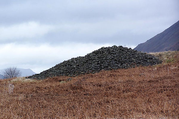 BLP96.jpg Pretty unexciting, and probably piled up anew by navvies. (taken 15.2.2006) |
||
|
|
||
| evidence:- | old map:- OS County Series (Cmd 76 1) placename:- Dunmail Raise |
|
| source data:- | Maps, County Series maps of Great Britain, scales 6 and 25
inches to 1 mile, published by the Ordnance Survey, Southampton,
Hampshire, from about 1863 to 1948. |
|
|
|
||
| evidence:- | old map:- Saxton 1579 placename:- Dunbalrase Stones |
|
| source data:- | Map, hand coloured engraving, Westmorlandiae et Cumberlandiae Comitatus ie Westmorland
and Cumberland, scale about 5 miles to 1 inch, by Christopher Saxton, London, engraved
by Augustinus Ryther, 1576, published 1579-1645.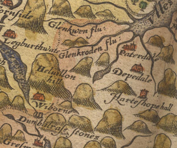 SAX9NY31.jpg "Dunbalrase stones" 2 stones on the county boundary. item:- private collection : 2 Image © see bottom of page |
|
|
|
||
| evidence:- | old map:- Mercator 1595 (edn?) |
|
| source data:- | Map, hand coloured engraving, Northumbria, Cumberlandia, et
Dunelmensis Episcopatus, ie Northumberland, Cumberland and
Durham etc, scale about 6.5 miles to 1 inch, by Gerard Mercator,
Duisberg, Germany, about 1595.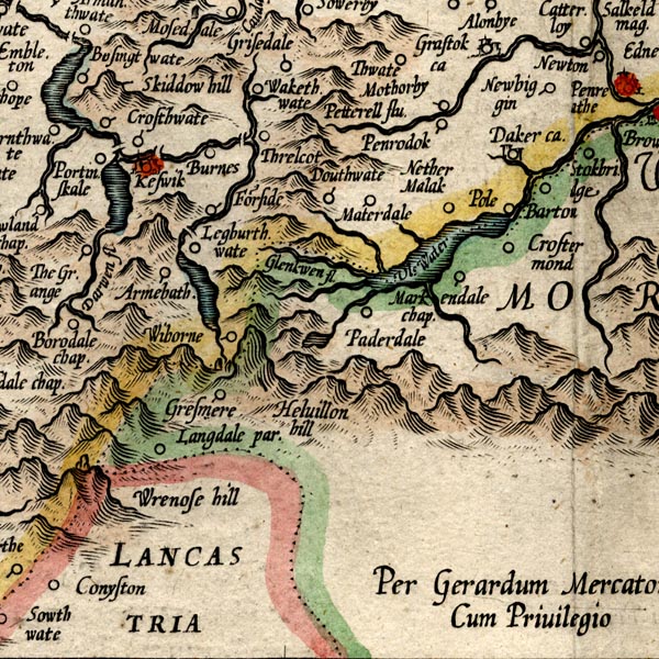 MER8CumF.jpg "" stones at county boundary with Westmorland item:- JandMN : 169 Image © see bottom of page |
|
|
|
||
| evidence:- | old map:- Speed 1611 (Cmd) placename:- Dunbalrase Stones |
|
| source data:- | Map, hand coloured engraving, Cumberland and the Ancient Citie
Carlile Described, scale about 4 miles to 1 inch, by John Speed,
1610, published by J Sudbury and George Humble, Popes Head
Alley, London, 1611-12.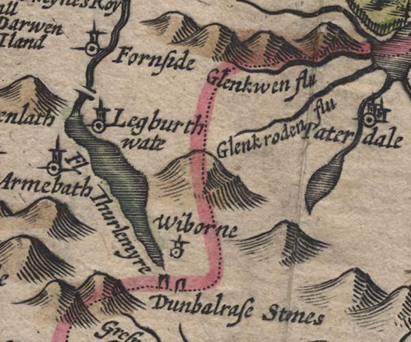 SP11NY31.jpg "Dunbalrase Stones" two standing stones on the county boundary item:- private collection : 16 Image © see bottom of page |
|
|
|
||
| evidence:- | old map:- Speed 1611 (Wmd) placename:- Dunbalrase Stones |
|
| source data:- | Map, hand coloured engraving, The Countie Westmorland and
Kendale the Cheif Towne, scale about 2.5 miles to 1 inch, by
John Speed, 1610, published by George Humble, Popes Head Alley,
London, 1611-12.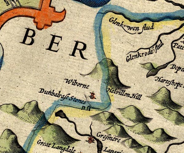 SP14NY31.jpg "Dunbalrase Stones" two standing stones; on county boundary item:- Armitt Library : 2008.14.5 Image © see bottom of page |
|
|
|
||
| evidence:- | old map:- Jansson 1646 placename:- Dunbalrase Stones |
|
| source data:- | Map, hand coloured engraving, Cumbria and Westmoria, ie
Cumberland and Westmorland, scale about 3.5 miles to 1 inch, by
John Jansson, Amsterdam, Netherlands, 1646.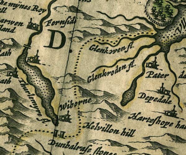 JAN3NY31.jpg "Dunbalrase stones" Marked by two very square pillars; at county boundary. item:- JandMN : 88 Image © see bottom of page |
|
|
|
||
| evidence:- | old map:- Ogilby 1675 (plate 96) placename:- Dunmaile Raise Stones |
|
| source data:- | Road strip map, hand coloured engraving, the Road from Kendal to
Cockermouth, and the Road from Egremond to Carlisle, scale about
1 inch to 1 mile, by John Ogilby, London, 1675.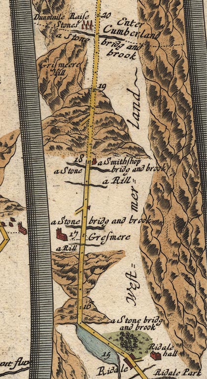 OG96m015.jpg In mile 19, Cumberland. "Dunmaile Raise Stones" six standing stones on the left of the road. item:- JandMN : 22 Image © see bottom of page |
|
|
|
||
| evidence:- | old map:- Seller 1694 (Wmd) placename:- Dunbalrase Stones |
|
| source data:- | Map, hand coloured engraving, Westmorland, scale about 8 miles
to 1 inch, by John Seller, 1694. click to enlarge click to enlargeSEL7.jpg "Dunbalrase stones" two standing stones; on county boundary item:- Dove Cottage : 2007.38.87 Image © see bottom of page |
|
|
|
||
| evidence:- | old map, descriptive text:- Bowen 1720 (plate 260) placename:- Dunmail Raise Stones |
|
| source data:- | Road strip map, uncoloured engraving, pl.260, The Road from
Kendal to Cockermouth, scale about 2 miles to 1 inch, with
sections in Westmorland and Cumberland, published by Emanuel
Bowen, St Katherines, London, 1720.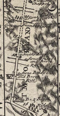 B260m15.jpg Between mile 19 and 20, enter Cumberland, Dunmail Raise Stones drawn by 6 upstanding stones on left, west, of road. "Dunmail Raise Stones Are supposed to have been erected by Dunmail K. of Cumberland for ye bounds of his Kingdom. (at 20)" item:- private collection : 1.260 Image © see bottom of page |
|
|
|
||
| evidence:- | old map:- Simpson 1746 map (Wmd) placename:- Dunmaile Raise Stones |
|
| source data:- | Map, uncoloured engraving, Westmorland, scale about 8 miles to 1
inch, printed by R Walker, Fleet Lane, London, 1746.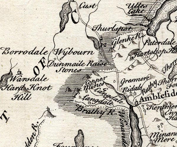 SMP2NYF.jpg "Dunmaile Raise Stones" item:- Dove Cottage : 2007.38.59 Image © see bottom of page |
|
|
|
||
| evidence:- | old map:- Bowen and Kitchin 1760 placename:- Dunmail Raise Stones |
|
| source data:- | Map, hand coloured engraving, A New Map of the Counties of
Cumberland and Westmoreland Divided into their Respective Wards,
scale about 4 miles to 1 inch, by Emanuel Bowen and Thomas
Kitchin et al, published by T Bowles, Robert Sayer, and John
Bowles, London, 1760.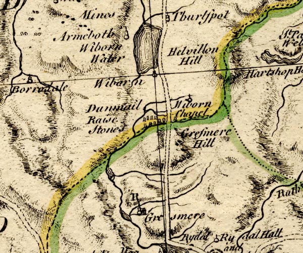 BO18NY20.jpg "Dunmail Raise Stones" array of standing stones, mostly W of road item:- Armitt Library : 2008.14.10 Image © see bottom of page |
|
|
|
||
| evidence:- | old map:- Jefferys 1770 (Wmd) placename:- Dummel Wrays Stones |
|
| source data:- | Map, 4 sheets, The County of Westmoreland, scale 1 inch to 1
mile, surveyed 1768, and engraved and published by Thomas
Jefferys, London, 1770.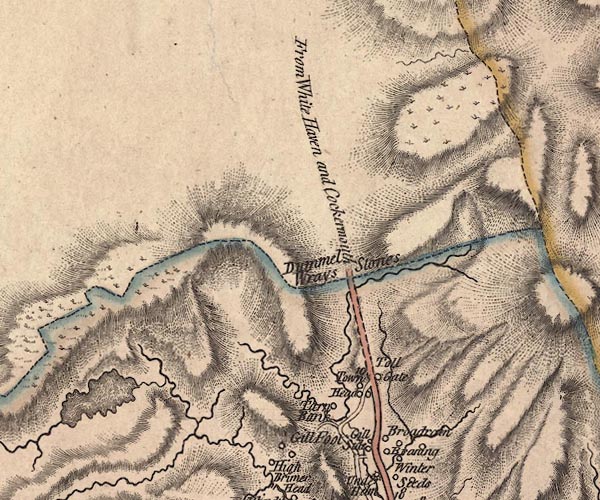 J5NY31SW.jpg "Dummel Wrays Stones" no symbol, on county boundary item:- National Library of Scotland : EME.s.47 Image © National Library of Scotland |
|
|
|
||
| evidence:- | old map:- Donald 1774 (Cmd) placename:- Dunmelraise Stones |
|
| source data:- | Map, hand coloured engraving, 3x2 sheets, The County of Cumberland, scale about 1
inch to 1 mile, by Thomas Donald, engraved and published by Joseph Hodskinson, 29
Arundel Street, Strand, London, 1774.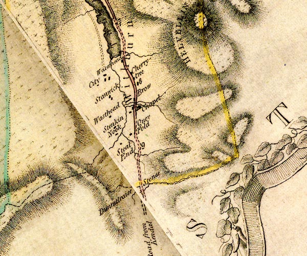 D4NY31SW.jpg "Dunmelraise Stones" on county boundary item:- Carlisle Library : Map 2 Image © Carlisle Library |
|
|
|
||
| evidence:- | old map:- West 1784 map placename:- Dunmail Raise Stones |
|
| source data:- | Map, hand coloured engraving, A Map of the Lakes in Cumberland,
Westmorland and Lancashire, scale about 3.5 miles to 1 inch,
engraved by Paas, 53 Holborn, London, about 1784.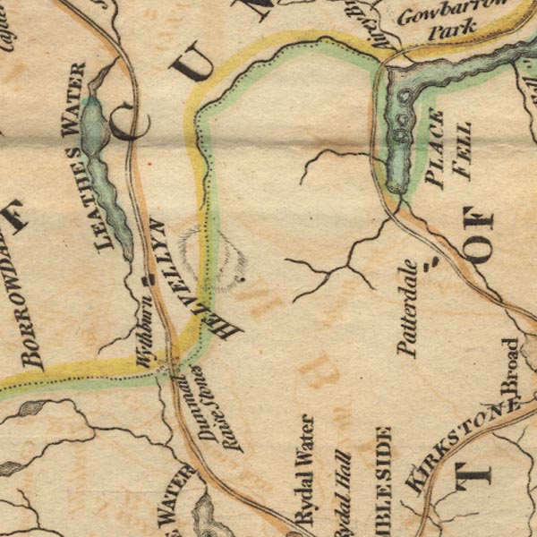 Ws02NY31.jpg A number of stones drawn either side of the road. item:- Armitt Library : A1221.1 Image © see bottom of page |
|
|
|
||
| evidence:- | old text:- Clarke 1787 item:- battle |
|
| source data:- | Guide book, A Survey of the Lakes of Cumberland, Westmorland,
and Lancashire, written and published by James Clarke, Penrith,
Cumberland, and in London etc, 1787; published 1787-93. goto source goto sourcePage 118:- "..." "... Rays-Gap, or Dunmail-Rays, ... Some will tell you that it had its name from Dunmail King of Cumberland, who in conjunction with Llewellyn King of South Wales, fought a battle with Edmund our Saxon King, and Malcolm King of Scots at this place; and that Edmund gained a com-" goto sourcePage 119:- "[com]pleat victory, slaying Dunmail, taking his two sons prisoners, and putting out there eyes; which also put an end to the Cumberland monarchs: That Dunmail was buried here underneath a very large kairn, (seen at this day close to the road,) whose magnitude and remains argues sufficiently that it was the tomb of a respected hero." "This is not a very improbable story, for this Dunmail assisted the Northumbrians against Edmund; and Edmund, though victorious, was so weakened, that he durst not pursue Dunmail, (who had gotten Llewellyn to join him,) without the assistance of the Scots. Malcolm King of Scots joined Edmund, upon this condition, that if they were successful, Malcolm should have Cumberland upon paying homage. Dunmail being obliged to fly for a while from his powerful enemies, was here determined to hazard a battle, both as having the advantage of the higher ground, and also being driven to the extremity of his kingdom, this being the place where Cumberland is yet divided from Westmorland, which battle proved fatal to him." "Matt. of Westminster says, Leolin, or Llewellyn, joined Edmund. Sim. of Durham says Llewellyn assisted Dunmail: of these two ancient and great historians I rather am inclined to believe the latter; for how could a petty king of Cumberland pretend to withstand the united forces of Edmund, Malcolm, and Llewellyn, after being defeated too? That Malcolm joined Edmund is very certain, for he had the country assigned to him upon condition of doing homage, and that he and his successors should assist Edmund and his successors both by sea and land, and own him as Lord Paramount." |
|
|
|
||
| evidence:- | old map:- Clarke 1787 map (Ambleside to Keswick) |
|
| source data:- | Map, A Map of the Roads Lakes etc between Keswick and Ambleside,
scale about 2.5 ins to 1 mile, by James Clarke, engraved by S J
Neele, 352 Strand, published by James Clarke, Penrith,
Cumberland and in London etc, 1787.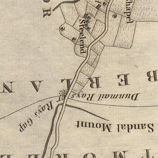 CL9NY31A.jpg Marked by a group of stones. item:- private collection : 10.9 Image © see bottom of page |
|
|
|
||
| evidence:- | old text:- Camden 1789 (Gough Additions) placename:- Dunmail Wray's Stones |
|
| source data:- | Book, Britannia, or A Chorographical Description of the Flourishing Kingdoms of England,
Scotland, and Ireland, by William Camden, 1586, translated from the 1607 Latin edition
by Richard Gough, published London, 1789. goto source Page 155:- "..." "On a high pass between the hills near Rydal is a large Carnedd called Dunmail Wray's stones, collected in memory of a defeat given 946 to a petty king of Cumberland by Edmund I. who gave his territory to Malcolm king of Scotland, on consideration he preserved the peace of the North of England. The map makes it nine single stones." "Dunmail Raise is a large mountain, great part whereof is in Gresmere parish, and is so called from a heap or raise of stones by the road side, which divides Cumberland from this county, thrown together either by Dunmail king of Cumberland as a mark of the utmost border of his kingdom, or by some other in memory of him." |
|
|
|
||
| evidence:- | road book:- Cary 1798 (2nd edn 1802) placename:- Dunmel Wrays Stones |
|
| source data:- | Road book, itineraries, Cary's New Itinerary, by John Cary, 181
Strand, London, 2nd edn 1802. goto source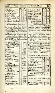 click to enlarge click to enlargeC38317.jpg page 317-318 "Dunmel Wrays Stones" item:- JandMN : 228.1 Image © see bottom of page |
|
|
|
||
| evidence:- | old map:- Cooke 1802 placename:- Dunmel Raise Stones |
|
| source data:- | Map, The Lakes, Westmorland and Cumberland, scale about 8.5
miles to 1 inch, engravedby Neele and Son, published by
Sherwood, Jones and Co, Paternoster Road, London, 1824. click to enlarge click to enlargeGRA1Lk.jpg "Dunmel Raise Stones" by county boundary item:- Hampshire Museums : FA2000.62.5 Image © see bottom of page |
|
|
|
||
| evidence:- | old text:- Gents Mag item:- boundary mark |
|
| source data:- | Magazine, The Gentleman's Magazine or Monthly Intelligencer or
Historical Chronicle, published by Edward Cave under the
pseudonym Sylvanus Urban, and by other publishers, London,
monthly from 1731 to 1922. goto source Gentleman's Magazine 1805 p.1011 "..." "We now ascended Dunmail Raise, so named from Dunmail, the last King of Cumberland, who was defeated and buried here by Edward the Saxon. The place of his interment, marked by a rude heap of stones, is still retained as the line of demarkation between the counties. ..." |
|
|
|
||
| evidence:- | old map:- Laurie and Whittle 1806 placename:- Dunmail Raise Stones |
|
| source data:- | Road map, Completion of the Roads to the Lakes, scale about 10
miles to 1 inch, by Nathaniel Coltman? 1806, published by Robert
H Laurie, 53 Fleet Street, London, 1834. click to enlarge click to enlargeLw18.jpg "Dunmail Raise Stones 284¼" stones; distance from London; on county boundary item:- private collection : 18.18 Image © see bottom of page |
|
|
|
||
| evidence:- | old print:- Wilkinson 1810 (plate 16) item:- cart |
|
| source data:- | Print, uncoloured soft ground etching, Dulmail Raise, on the Ambleside Road, Cumberland,
by Joseph Wilkinson, engraved by William Frederick Wells, published by R Ackermann,
Repository of Arts, 101 Strand, London, 1810.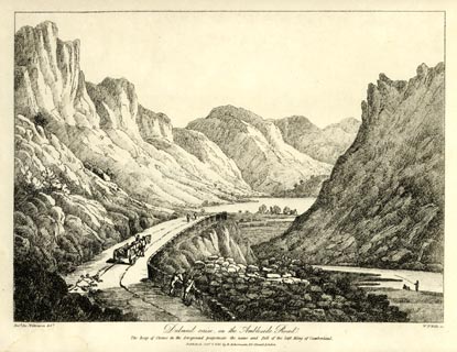 click to enlarge click to enlargeWKN116.jpg Plate 16 in Select Views in Cumberland, Westmoreland, and Lancashire. printed at bottom left, right, centre:- "Revd. Jos: Wilkenson delt. / W: F: Wells sc. / Dulmail Raise, on the Ambleside Road. / The heap of stones in the foreground perpetuate the name and fall of the last King of Cumberland / Published Octr. 1. 1810. by R. Ackermann. 101. Strand. London." item:- Fell and Rock Climbing Club : MN4.16 Image © see bottom of page |
|
|
|
||
| evidence:- | old text:- Gents Mag placename:- Dunmelwrays |
|
| source data:- | Magazine, The Gentleman's Magazine or Monthly Intelligencer or
Historical Chronicle, published by Edward Cave under the
pseudonym Sylvanus Urban, and by other publishers, London,
monthly from 1731 to 1922. goto source Gentleman's Magazine 1825 part 1 p.414 From the Compendium of County History:- "946. Edmund wasted Cumbria, and having put out the eyes of the two sons of Dunmail, gave that province to Malcolm, King of Scotland. Dun-mel-wrays is supposed to have been erected in memory of it, or as a boundary of Dunmail's kingdoms." |
|
|
|
||
| evidence:- | descriptive text:- Ford 1839 (3rd edn 1843) |
|
| source data:- | Guide book, A Description of Scenery in the Lake District, by
Rev William Ford, published by Charles Thurnam, Carlisle, by W
Edwards, 12 Ave Maria Lane, Charles Tilt, Fleet Street, William
Smith, 113 Fleet Street, London, by Currie and Bowman,
Newcastle, by Bancks and Co, Manchester, by Oliver and Boyd,
Edinburgh, and by Sinclair, Dumfries, 1839. goto source Page 45:- "DUNMAIL RAISE" "Is a cairn or burrow of stones, marking the place where the last king of Cumbria was defeated by the Saxon Edmund, who put out the eyes of the son before the father's face, wasted his kingdom, and then gave it to Malcolm, king of Scotland, to hold in fealty. The wall dividing the counties is built over it, and the road is partly cut through it. ..." goto sourcePage 164:- "..." "DUNMAIL RAISE is a large cairn, now marking the boundary line between Westmorland and Cumberland: tradition ascribes it to the memory of a British king of that name, who was here defeated and slain in battle by Edmund I. of England. ..." |
|
|
|
||
| evidence:- | old map:- Ford 1839 map placename:- Dunmail Raise Stones |
|
| source data:- | Map, uncoloured engraving, Map of the Lake District of
Cumberland, Westmoreland and Lancashire, scale about 3.5 miles
to 1 inch, published by Charles Thurnam, Carlisle, and by R
Groombridge, 5 Paternoster Row, London, 3rd edn 1843.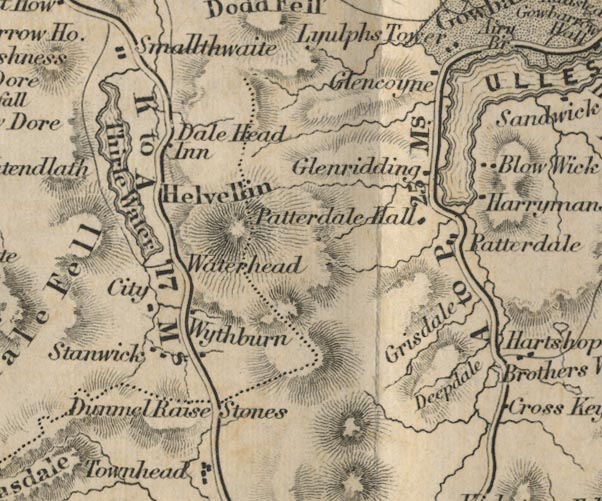 FD02NY31.jpg "Dunmail Raise Stones" No symbol, at county border. item:- JandMN : 100.1 Image © see bottom of page |
|
|
|
||
| evidence:- | old text:- Martineau 1855 |
|
| source data:- | Guide book, A Complete Guide to the English Lakes, by Harriet
Martineau, published by John Garnett, Windermere, Westmorland,
and by Whittaker and Co, London, 1855; published 1855-76. goto source Page 68:- "... Dunmail Raise ... The cairn,- a rude mass of stones near the top of the ascent, which the stranger should be on the look out for, marks the spot of a critical conflict in the olden time,- that is, in A.D. 945,- when the Anglo Saxon King Edmund defeated and slew Dunmail, the British King of Cumbria, and then put out the eyes of the two sons of his slain foe, and gave their inheritance to Malcolm, King of Scotland." |
|
|
|
||
| evidence:- | descriptive text:- West 1778 (11th edn 1821) |
|
| source data:- | Guide book, A Guide to the Lakes, by Thomas West, published by
William Pennington, Kendal, Cumbria once Westmorland, and in
London, 1778 to 1821. goto source Page 83:- "... this road ascends Dunmail-raise, where lie the historical stones, that perpetuate the name and fall of the last king of Cumberland, defeated there by the Saxon monarch Edmund, who put out the eyes of the two sons of his adversary, and for his confederating with Leolin, king of Wales, first wasted his kingdom, and then gave it to Malcolm, king of Scots, who held it in fee of Edmund, A.D. 944, or 945. The stones are a heap, that have the appearance of a karn, or barrow. The wall that divides the counties is built over them; which proves their priority of time in that form." |
|
|
|
||
| hearsay:- |
The pile of stones marks the boundary between Westmorland and Cumberland, and once
marked the boundary between England and Scotland. |
|
| It may also commemorate the defeat of Dunmail or Duvenald, King of Cumberland, by
Edmund of Northumbria and Leolin of Wales, in 945. After this defeat Edmund gave Cumberland
to King Malcolm of Scotland, it was returned to England, to King Canute or Knut, in
1032. |
||
|
|
||
Lakes Guides menu.