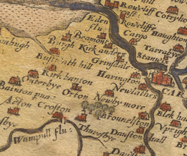
 Saxton 1576 NY35


|

|
|
|
gazetteer links places may or may not be labelled on the map |
||

|
-- Beaumont -- "Beamont" |
|
|
|
-- Boustead Hill -- "Bustwath hill" |
|
|
|
-- |
|
|
|
-- Brownelson -- "Brounelston" |
|
|
|
-- Burgh by Sands -- "Burgh" |
|
|
|
-- Caldew Bridge |
|
|
|
-- Caldew, River -- "Cauda flu:" |
|
|
|
-- Cargo -- "Cargo" |
|
|
|
-- Crofton -- "Croston" |
|
|
|
-- Dalston Hall -- "Dauston hall" |
|
|
|
-- Eden, River -- "Eden flu:" -- "Eden flu:"
-- "Eden flu:" -- "Eden flu:" |
|
|
|
-- Grass Dike |
|
|
|
-- Great Orton -- "Orton" |
|
|
|
-- Grinsdale -- "Grinsdale" |
|
|
|
-- Harington (?) -- "Harington" |
|
|
|
-- Kirkandrews upon Eden -- "Kirkanders" |
|
|
|
-- Kirkbampton -- "Kirk banton" |
|
|
|
-- Newby West -- "Newby more" |
|
|
|
-- Newlaiths Hall -- "Newlathes" |
|
|
|
-- Rockcliffe -- "Rowcliffe" |
|
|
|
-- Thursby -- "Thuresbye" |
|
|
|
-- Wampool, River -- "Wampull flu:" -- "Wampull
flu:" |
|
|
civil parishes The area roughly includes parts of parishes:- Thursby Cummersdale Carlisle St Cuthbert Without Orton N Stanwix Rural Kirkbampton Burgh by Sands Beaumont Dalston Aikton Kingmoor |
||
|
|
||
|
|
Lakes Guides menu. | |