 Old Cumbria Gazetteer
 |
 |
|
||||||||||||||||||||||||
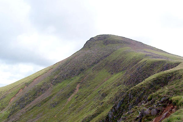
| Red Pike, Buttermere | ||||||||||||||||||||||||||
| Red Pike | ||||||||||||||||||||||||||
| civil parish:- | Buttermere (formerly Cumberland) | |||||||||||||||||||||||||
| civil parish:- | Loweswater (formerly Cumberland) | |||||||||||||||||||||||||
| civil parish:- | Ennerdale and Kinniside (formerly Cumberland) | |||||||||||||||||||||||||
| county:- | Cumbria | |||||||||||||||||||||||||
| locality type:- | hill | |||||||||||||||||||||||||
| coordinates:- | NY16051545 | |||||||||||||||||||||||||
| 1Km square:- | NY1615 | |||||||||||||||||||||||||
| 10Km square:- | NY11 | |||||||||||||||||||||||||
| altitude:- | 2477 feet | |||||||||||||||||||||||||
| altitude:- | 755m | |||||||||||||||||||||||||
|
|
||||||||||||||||||||||||||
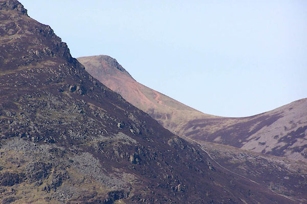 BLY16.jpg From low down Honister Pass. (taken 24.4.2006) 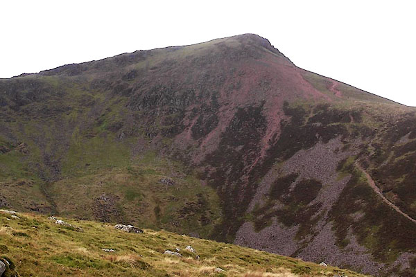 BVQ06.jpg (taken 1.11.2011) |
||||||||||||||||||||||||||
|
|
||||||||||||||||||||||||||
| evidence:- | old map:- OS County Series (Cmd 69 10) placename:- Red Pike |
|||||||||||||||||||||||||
| source data:- | Maps, County Series maps of Great Britain, scales 6 and 25
inches to 1 mile, published by the Ordnance Survey, Southampton,
Hampshire, from about 1863 to 1948. |
|||||||||||||||||||||||||
|
|
||||||||||||||||||||||||||
| evidence:- | old map:- Gents Mag 1751 placename:- Red Pike |
|||||||||||||||||||||||||
| source data:- | Map, uncoloured engraving, Map of the Black Lead Mines in
Cumberland, and area, scale about 2 miles to 1 inch, by George
Smith, published in the Gentleman's Magazine, 1751.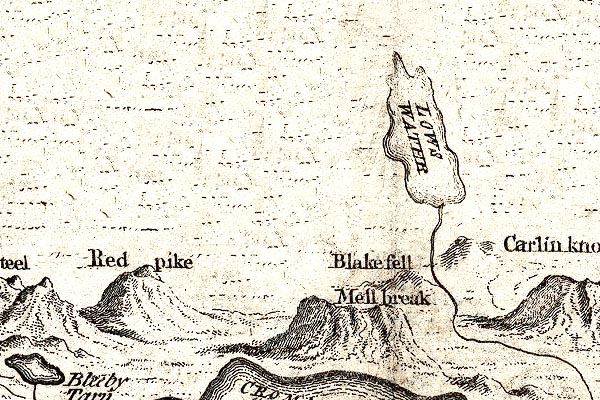 GM1302.jpg "Red pike" knobbly hillocks; mountains item:- JandMN : 114 Image © see bottom of page |
|||||||||||||||||||||||||
|
|
||||||||||||||||||||||||||
| evidence:- | old map:- Donald 1774 (Cmd) placename:- Red Pike |
|||||||||||||||||||||||||
| source data:- | Map, hand coloured engraving, 3x2 sheets, The County of Cumberland, scale about 1
inch to 1 mile, by Thomas Donald, engraved and published by Joseph Hodskinson, 29
Arundel Street, Strand, London, 1774.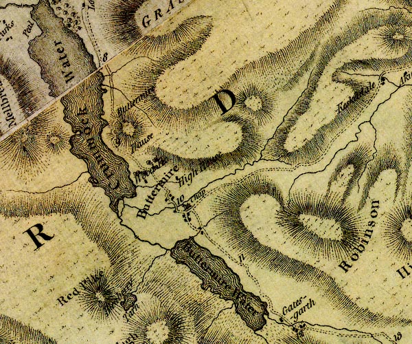 D4NY11NE.jpg "Red Pike" hill hachuring; a hill or mountain item:- Carlisle Library : Map 2 Image © Carlisle Library |
|||||||||||||||||||||||||
|
|
||||||||||||||||||||||||||
| evidence:- | descriptive text:- West 1778 (11th edn 1821) placename:- Redpike |
|||||||||||||||||||||||||
| source data:- | Guide book, A Guide to the Lakes, by Thomas West, published by
William Pennington, Kendal, Cumbria once Westmorland, and in
London, 1778 to 1821. goto source goto sourcePage 134:- "Descend the track on the left, and you soon have in sight the highest possible contrast in nature. Four spiral towering mountains, dark, dun, and gloomy at noon-day, rise immediately from the western extremity of the deep narrow dell, and hang over Buttermere. The more southern is, by the dalesmen, from its form, called Hay-rick; the more pyramidal High-crag; the third High-style; and the fourth, from its ferruginous colour, Red-pike. ..." "... ..." goto sourcePage 190:- "A TABLE OF THE Height of Mountains and Lakes SEEN IN THIS TOUR, ... TAKEN FROM THE LEVEL OF THE SEA. ... by Mr. John Dalton." "Redpike, near Buttermere ... 950 [yards]" goto sourceAccount of Ennerdale, late 18th century Page 293:- "..." "... As he approaches the vale of Ennerdale, ... he will find the rugged scenery of the country gradually refining; and as he winds round the foot of the Pillar, he will discover a vista, which cannot fail to strike the most indifferent observer with astonishment and pleasure." "The mountains which serve to heighten this scene, and enhance its surprise, are Sty-head, Honister-crag, Wastdale, the Pillar, and Red-pike. ..." |
|||||||||||||||||||||||||
|
|
||||||||||||||||||||||||||
| evidence:- | old map:- West 1784 map placename:- Red Pike |
|||||||||||||||||||||||||
| source data:- | Map, hand coloured engraving, A Map of the Lakes in Cumberland,
Westmorland and Lancashire, scale about 3.5 miles to 1 inch,
engraved by Paas, 53 Holborn, London, about 1784.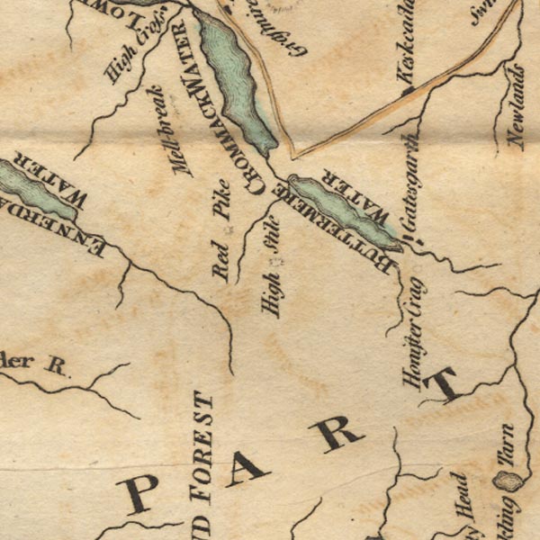 Ws02NY11.jpg Marked by a tiny circle of hachuring. item:- Armitt Library : A1221.1 Image © see bottom of page |
|||||||||||||||||||||||||
|
|
||||||||||||||||||||||||||
| evidence:- | old text:- Green 1810 placename:- Red Pike |
|||||||||||||||||||||||||
| source data:- | Set of prints, soft ground etchings, Sixty Studies from Nature,
by William Green, Ambleside, Westmorland, drawn 1808-10,
published 1810. goto source page 68:- "... The four conical topped mountains, High Pike, High Steel, High Crag, and Red Pike, are on the western side of the lake of Buttermere, ..." |
|||||||||||||||||||||||||
|
|
||||||||||||||||||||||||||
| evidence:- | old text:- Green 1814 placename:- Red Pike |
|||||||||||||||||||||||||
| source data:- | Set of prints, soft ground etchings, Sixty Small Prints, with
text, A Description of a Series of Sixty Small Prints, by
William Green, Ambleside, Westmorland, 1814. goto source page 21:- "... The four conical-topped mountains, High Pike, High Steel, High Crag, and Red Pike, are on the western side of the lake of Buttermere, ..." |
|||||||||||||||||||||||||
|
|
||||||||||||||||||||||||||
| evidence:- | old map:- Otley 1818 placename:- Red Pike |
|||||||||||||||||||||||||
| source data:- | Map, uncoloured engraving, The District of the Lakes,
Cumberland, Westmorland, and Lancashire, scale about 4 miles to
1 inch, by Jonathan Otley, 1818, engraved by J and G Menzies,
Edinburgh, Scotland, published by Jonathan Otley, Keswick,
Cumberland, et al, 1833.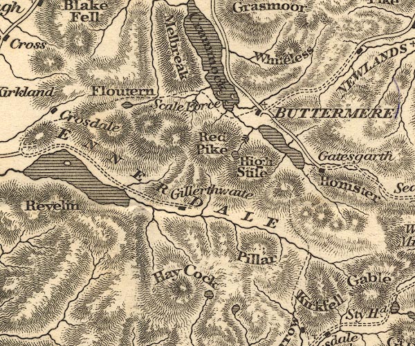 OT02NY11.jpg item:- JandMN : 48.1 Image © see bottom of page |
|||||||||||||||||||||||||
|
|
||||||||||||||||||||||||||
| evidence:- | outline view:- Otley 1823 (4th edn 1830) placename:- Red Pike |
|||||||||||||||||||||||||
| source data:- | Print, engraving, outline view, Some of the Western Mountains as seen from Helvellyn,
published by Jonathan Otley, Keswick, Cumberland et al, 1830.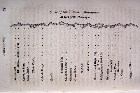 click to enlarge click to enlargeO75E02.jpg p.57 in A Concise Description of the English Lakes, by Jonathan Otley, 4th edition, 1830. "Some of the Western Mountains: / as seen from Helvellyn." "Wetherlam / Old Man - Coniston Fell / Carrs, or Scars / Gray Friar / Black Combe / Crinkle Crags / Bowfell / Scawfell Pike / Great-end Crag / Glaramara / Great Gable / Kirkfell / Pillar Fell / Honister and High Crag / High Stile / Dalehead and Red Pike / Robinson / Blake Fell / Witeless Pike / Grasmoor / Ill Crags / Grisedale Pike" item:- Armitt Library : A1175.3 Image © see bottom of page |
|||||||||||||||||||||||||
|
|
||||||||||||||||||||||||||
| evidence:- | outline view:- Otley 1823 (4th edn 1830) placename:- Red Pike |
|||||||||||||||||||||||||
| source data:- | Print, engraving, outline view, Mountains South West of Derwentwater as seen from
Keswick, published by Jonathan Otley, Keswick, Cumberland et al, 1830.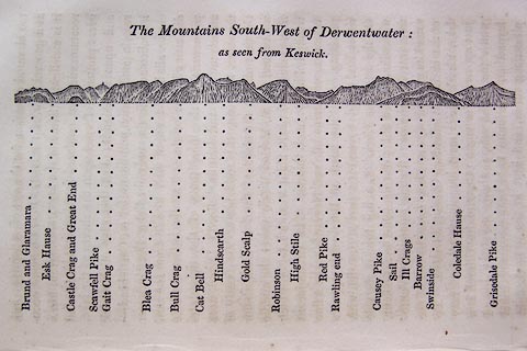 click to enlarge click to enlargeO75E06.jpg p.115 in A Concise Description of the English Lakes, by Jonathan Otley, 4th edition, 1830. "The Mountains South-West of Derwentwater: / as seen from Keswick." "Brund and Glaramara / Esk Hause / Castle Crag and Great End / Scawfell Pike / Gait Crag / Blea Crag / Bull Crag / Cat Bell / Hindscarth / Gold Scalp / Robinson / High Stile / Red Pike / Rawling end / Causey Pike / Sail / Ill Crags / Barrow / Swinside / Coledale Hause / Grisedale Pike" item:- Armitt Library : A1175.6 Image © see bottom of page |
|||||||||||||||||||||||||
|
|
||||||||||||||||||||||||||
| evidence:- | outline view:- Otley 1823 (4th edn 1830) placename:- Red Pike |
|||||||||||||||||||||||||
| source data:- | Print, engraving, outline view, The Mountains of Crummock and Buttermere as seen on
the Road between Scale-Hill and Loweswater, published by Jonathan Otley, Keswick,
Cumberland et al, 1830.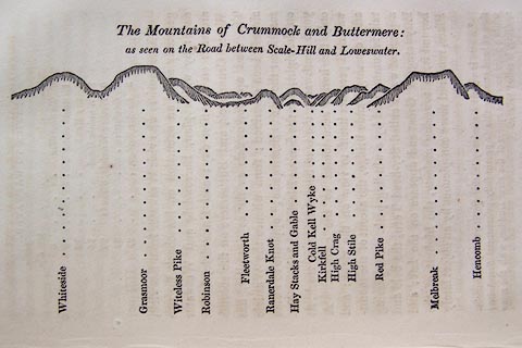 click to enlarge click to enlargeO75E07.jpg p.125 in A Concise Description of the English Lakes, by Jonathan Otley, 4th edition, 1830. "The Mountains of Crummock and Buttermere: / as seen on the Road between Scale-Hill and Loweswater." "Whiteside / Grasmoor / Witeless Pike / Robinson / Fleetworth / Rannerdale Knot / Hay Stacks and Gable / Cold Kell Wyke / Kirkfell / High Crag / High Stile / Red Pike / Melbreak / Hencomb" item:- Armitt Library : A1175.7 Image © see bottom of page |
|||||||||||||||||||||||||
|
|
||||||||||||||||||||||||||
| evidence:- | outline view:- Otley 1823 (8th edn 1849) placename:- Red Pike |
|||||||||||||||||||||||||
| source data:- | Engraving, outline view of mountains, Derwent Water from Crow Park, drawn by T Binns,
engraved by O Jewitt, opposite p.10 of A Descriptive Guide of the English Lakes, by
Jonathan Otley, 8th edition, 1849.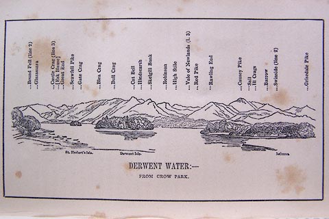 click to enlarge click to enlargeO80E06.jpg item:- Armitt Library : A1180.7 Image © see bottom of page |
|||||||||||||||||||||||||
|
|
||||||||||||||||||||||||||
| evidence:- | outline view:- Otley 1823 (8th edn 1849) placename:- Red Pike |
|||||||||||||||||||||||||
| source data:- | Engraving, outline view of mountains, Crummock and Buttermere from the Road near Loweswater
Church, drawn by T Binns, engraved by O Jewitt, opposite p.18 of A Descriptive Guide
of the English Lakes, by Jonathan Otley, 8th edition, 1849.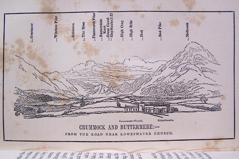 click to enlarge click to enlargeO80E10.jpg item:- Armitt Library : A1180.11 Image © see bottom of page |
|||||||||||||||||||||||||
|
|
||||||||||||||||||||||||||
| evidence:- | outline view:- Otley 1823 (8th edn 1849) placename:- Red Pike |
|||||||||||||||||||||||||
| source data:- | Engraving, outline view of mountains, Ennerdale from a Field near Kirkland and Salter,
drawn by T Binns, engraved by O Jewitt, opposite p.20 of A Descriptive Guide of the
English Lakes, by Jonathan Otley, 8th edition, 1849.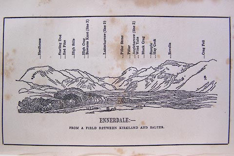 click to enlarge click to enlargeO80E11.jpg item:- Armitt Library : A1180.12 Image © see bottom of page |
|||||||||||||||||||||||||
|
|
||||||||||||||||||||||||||
| evidence:- | outline view:- Otley 1823 (8th edn 1849) placename:- Red Pike |
|||||||||||||||||||||||||
| source data:- | Engraving, outline view of mountains, A Group of Mountains seen from Helvellyn, looking
towards the South West, drawn by T Binns, engraved by O Jewitt, opposite p.50 of A
Descriptive Guide of the English Lakes, by Jonathan Otley, 8th edition, 1849.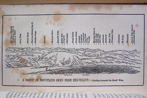 click to enlarge click to enlargeO80E17.jpg item:- Armitt Library : A1180.18 Image © see bottom of page |
|||||||||||||||||||||||||
|
|
||||||||||||||||||||||||||
| evidence:- | outline view:- Otley 1823 (5th edn 1834) |
|||||||||||||||||||||||||
| source data:- | Print, woodcut outline view, The Mountains South West of
Derwentwater, by Jonathan Otley, Keswick, Cumberland, 1830.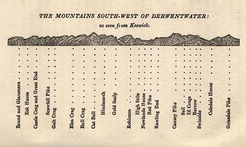 click to enlarge click to enlargeOT2E04.jpg Printed on p.21 of A Concise Description of the English Lakes, by Jonathan Otley, 5th edition, 1834. "THE MOUNTAINS SOUTH-WEST OF DERWENTWATER: as seen from Keswick" "Brund and Glaramara / Esk Hause / Castle Crag and Great End / Scawfell Pike / Gait Crag / Blea Crag / Bull Crag / Cat Bell / Hindscarth / Gold Scalp / Robinson / High Stile / Newlands Hause / Red Pike / Rawling End / Causey Pike / Sail / Ill Crags / Barrow / Swinside / Coledale Hause / Grisedale Pike" item:- JandMN : 48.5 Image © see bottom of page |
|||||||||||||||||||||||||
|
|
||||||||||||||||||||||||||
| evidence:- | outline view:- Otley 1823 (5th edn 1834) |
|||||||||||||||||||||||||
| source data:- | Print, woodcut outline view, The Mountains of Crummock and
Buttermere, by Jonathan Otley, Keswick, Cumberland, 1830.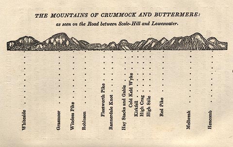 click to enlarge click to enlargeOT2E05.jpg Printed on p.25 of A Concise Description of the English Lakes, by Jonathan Otley, 5th edition, 1834. "THE MOUNTAINS OF CRUMMOCK AND BUTTERMERE: as seen on the Road between Scale-Hill and Loweswater." "Whiteside / Grasmoor / Witeless Pike / Robinson / Fleetworth Pike / Rannerdale Knot / Hay Stacks and Gable / Cold Keld Wyke / Kirkfell / High Crag / High Stile / Red Pike / Melbreak / Hencomb" item:- JandMN : 48.6 Image © see bottom of page |
|||||||||||||||||||||||||
|
|
||||||||||||||||||||||||||
| evidence:- | outline view:- Otley 1823 (5th edn 1834) |
|||||||||||||||||||||||||
| source data:- | Print, woodcut outline view, A Group of Mountains, seen from
Helvellyn, by Jonathan Otley, Keswick, Cumberland, 1830.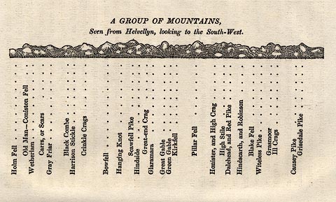 click to enlarge click to enlargeOT2E09.jpg Printed on p.63 of A Concise Description of the English Lakes, by Jonathan Otley, 5th edition, 1834. "A GROUP OF MOUNTAINS, Seen from Helvellyn, looking to the South-West." "Holm Fell / Old Man - Coniston Fell / Wetherlam / Carrs, or Scars / Gray Friar / Black Combe / Harrison Stickle / Crinkle Crags / Bowfell / Hanging Knot / Scawfell Pike / Hindside / Great-end Crag / Glaramara / Great Gable / Green Gable / Kirkfell / Pillar Fell / Honister, and High Crag / High Stile / Dalehead, and Red Pike / Hindscarth, and Robinson / Blake Fell / Witeless Pike / Grasmoor / Ill Crags / Causey Pike / Grisedale Pike" item:- JandMN : 48.10 Image © see bottom of page |
|||||||||||||||||||||||||
|
|
||||||||||||||||||||||||||
| evidence:- | descriptive text:- Otley 1823 (5th edn 1834) item:- geology |
|||||||||||||||||||||||||
| source data:- | Guide book, A Concise Description of the English Lakes, the
mountains in their vicinity, and the roads by which they may be
visited, with remarks on the mineralogy and geology of the
district, by Jonathan Otley, published by the author, Keswick,
Cumberland now Cumbria, by J Richardson, London, and by Arthur
Foster, Kirkby Lonsdale, Cumbria, 1823; published 1823-49,
latterly as the Descriptive Guide to the English Lakes. goto source Page 126:- "... to the right [of Scarf Gap], three adjoining summits are called High-crag, High-stile, and Red-pike. The two first are composed of what some would call a porphyritic greenstone rock, the third of a reddish sienite: and between the second and third lies Burtness Tarn." |
|||||||||||||||||||||||||
|
|
||||||||||||||||||||||||||
| evidence:- | descriptive text:- Ford 1839 (3rd edn 1843) placename:- Red Pike item:- altitude, Red Pike |
|||||||||||||||||||||||||
| source data:- | Guide book, A Description of Scenery in the Lake District, by
Rev William Ford, published by Charles Thurnam, Carlisle, by W
Edwards, 12 Ave Maria Lane, Charles Tilt, Fleet Street, William
Smith, 113 Fleet Street, London, by Currie and Bowman,
Newcastle, by Bancks and Co, Manchester, by Oliver and Boyd,
Edinburgh, and by Sinclair, Dumfries, 1839. goto source "... THE Lake district ... consists of large masses or clusters of mountains, generally terminating in one aspiring and pre-eminent point, with the intermediate valleys occupied either by lakes and their subsidiary tarns, or by winding rivers." "The chief nuclei of these clusters are, Skiddaw and Blencathra, Helvellyn, Fairfield, Coniston Old Man, Blackcomb, Scafell, Gable, Red Pike, Grasmoor, Grisdale Pike, and the Langdale Pikes. Many noble and commanding mountains rise around these, rivalling them in height and grandeur, but still" goto sourcePage iv:- "serving as large buttresses only. In the presentation of endlessly-diversified forms, these Mountains yield to none, however individually inferior they may be, owing to their being seldom seen in a detached point of view; although, on the other hand, they have thus the advantage of forming combinations at once grand and sublime, towering above each other, or rising in ridges, like the mighty billows of the ocean." goto sourcePage 178:- "ELEVATION OF THE MOUNTAINS," "ACCORDING TO DIFFERENT AUTHORITIES."
|
|||||||||||||||||||||||||
|
|
||||||||||||||||||||||||||
| evidence:- | old map:- Ford 1839 map placename:- Red Pike |
|||||||||||||||||||||||||
| source data:- | Map, uncoloured engraving, Map of the Lake District of
Cumberland, Westmoreland and Lancashire, scale about 3.5 miles
to 1 inch, published by Charles Thurnam, Carlisle, and by R
Groombridge, 5 Paternoster Row, London, 3rd edn 1843.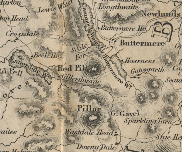 FD02NY11.jpg "Red Pike" Hill hachuring. item:- JandMN : 100.1 Image © see bottom of page |
|||||||||||||||||||||||||
|
|
||||||||||||||||||||||||||
| evidence:- | outline view:- Martineau 1855 |
|||||||||||||||||||||||||
| source data:- | Print, engraving, outline view, Mountains seen from Lanthwaite Wood Crummock Water,
drawn by L Aspland, engraved by W Banks, Edinburgh, published by John Garnett, Windermere,
Westmorland, and by Whittaker and Co, London, 1855.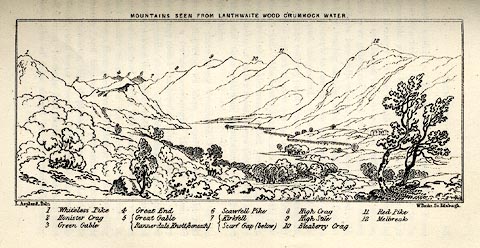 click to enlarge click to enlargeMNU113.jpg Opposite p.84 in A Complete Guide to the English Lakes, by Harriet Martineau. The view is captioned, numbers referring to mountains in the image:- "1 Whiteless Pike, 2 Honister Crag, 3 Green Gable, 4 Great End, 5 Great Gable / Rannerdale Knott (beneath), 6 Scawfell Pike, 7 Kirkfell / Scarf Gap (below), 8 High Crag, 9 High Stile, 10 Bleaberry Crag, 11 Red Pike, 12 Melbreak." "MOUNTAINS SEEN FROM LANTHWAITE WOOD CRUMMOCK WATER." "L Aspland Delt. / W Banks Sc Edinr." item:- Armitt Library : A1159.13 Image © see bottom of page |
|||||||||||||||||||||||||
|
|
||||||||||||||||||||||||||
| evidence:- | old text:- Martineau 1855 |
|||||||||||||||||||||||||
| source data:- | Guide book, A Complete Guide to the English Lakes, by Harriet
Martineau, published by John Garnett, Windermere, Westmorland,
and by Whittaker and Co, London, 1855; published 1855-76. goto source Page 85:- "... Red Pike discloses its crater; both being streaked with red and lead-coloured screes, and tracts of bright verdure and darker moss. ..." |
|||||||||||||||||||||||||
|
|
||||||||||||||||||||||||||
| evidence:- | outline view, old text:- Martineau 1855 |
|||||||||||||||||||||||||
| source data:- | Folded in opposite p.93 in A Complete Guide to the English Lakes, by Harriet Martineau. goto source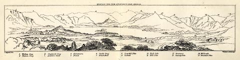 click to enlarge click to enlargeMNU114.jpg Print, engraving, outline view, Mountains seen from Applethwaite near Keswick, drawn by L Aspland, engraved by W Banks, Edinburgh, published by John Garnett, Windermere, Westmorland, and by Whittaker and Co, London, 1855. "MOUNTAINS SEEN FROM APPLETHWAITE NEAR KESWICK." "L Aspland Delt. / W Banks Sc Edinr." The view is captioned, numbers referring to mountains in the image:- "1 Wallow Crag, 2 Falcon Crag, 3 Shepherd's Crag / Lowdore below, 4 Glaramara, 5 Brund, 6 Castle Crag, 7 Great End, 8 Scawfell Pike, 9 Catbell, 10, High Stile, 11 Red Pike, 12 Grasmoor, 13 Causey Pike, 14 Melbreak, 15 Grisdale Pike" item:- Armitt Library : A1159.14 Image © see bottom of page |
|||||||||||||||||||||||||
|
|
||||||||||||||||||||||||||
| evidence:- | old text:- Martineau 1855 item:- altitude, Red Pike |
|||||||||||||||||||||||||
| source data:- | Guide book, A Complete Guide to the English Lakes, by Harriet
Martineau, published by John Garnett, Windermere, Westmorland,
and by Whittaker and Co, London, 1855; published 1855-76. goto source Page 179:- "A TABLE OF THE HEIGHTS OF MOUNTAINS IN THE COUNTIES OF CUMBERLAND, WESTMORLAND, AND LANCASHIRE." "No. : Names of Mountains. : Counties. : Height in Feet above the Sea Level." "12 : Red Pike, Buttermere : Cumberland : 2750" |
|||||||||||||||||||||||||
|
|
||||||||||||||||||||||||||
| evidence:- | outline view:- Barrow 1888 placename:- Red Pike |
|||||||||||||||||||||||||
| source data:- | Outline view, engraving? Outline of Mountain Tops as seen from the Keswick Hotel,
sketched by John Barrow, published by Sampson Low, Marston, Searle, and Rivington,
St Dunstan's House, Fetter Lane, Fleet Street, London, 1888.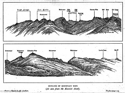 click to enlarge click to enlargeBRW1.jpg "... Red Pike ..." item:- Kendal Library : 10.3 Image © see bottom of page |
|||||||||||||||||||||||||
|
|
||||||||||||||||||||||||||
| evidence:- | outline view:- Jenkinson 1875 placename:- Red Pike |
|||||||||||||||||||||||||
| source data:- | Print, lithograph, outline view, Panoramic Sketches from Helvellyn, Westmorland, by
Edwin A Pettitt, London, published by Edward Stanford, 55 Charing Cross, London, 1875.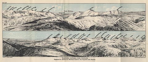 click to enlarge click to enlargeJk01E1.jpg "... Red Pike ..." item:- JandMN : 28.5 Image © see bottom of page |
|||||||||||||||||||||||||
|
|
||||||||||||||||||||||||||
| evidence:- | outline view:- Jenkinson 1875 placename:- Red Pike |
|||||||||||||||||||||||||
| source data:- | Print, lithograph, outline view, Panoramic Sketches from Scawfell Pike, Cumberland,
by Edwin A Pettitt, London, published by Edward Stanford, 55 Charing Cross, London,
1875.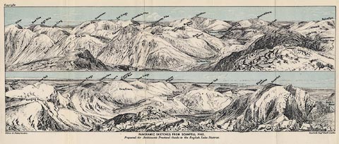 click to enlarge click to enlargeJk01E3.jpg "... Red Pike ..." item:- JandMN : 28.9 Image © see bottom of page |
|||||||||||||||||||||||||
|
|
||||||||||||||||||||||||||
| evidence:- | outline view:- Black 1856 placename:- Red Pike |
|||||||||||||||||||||||||
| source data:- | Print, lithograph, Outline Views, Buttermere - Mountains as seen from the Knots near
the Hotel at Buttermere, and Mountains as seen at the Seat in Lanthwaite Wood, Scale
Hill, by J Flintoft, Keswick, Cumberland, engraved by R Mason, Edinburgh, Lothian,
about 1900.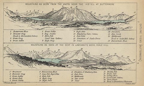 click to enlarge click to enlargeBC08E5.jpg "... 11 Red Pike ... 12 Red Pike ..." item:- JandMN : 37.19 Image © see bottom of page |
|||||||||||||||||||||||||
|
|
||||||||||||||||||||||||||
| evidence:- | outline view:- Black 1841 (3rd edn 1846) placename:- Red Pike |
|||||||||||||||||||||||||
| source data:- | Print, engraving, outline view, Mountains as seen from The Knots near the Victoria
at Buttermere, and Mountains as seen at the Seat in Lanthwaite Wood, Scale Hill, by
J Flintoft, Keswick, Cumberland, engraved by R Mason, Edinburgh, Lothian, about 1846.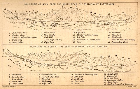 click to enlarge click to enlargeBC02E7.jpg "... 11 Red Pike ... 12 Red Pike ..." item:- JandMN : 32.11 Image © see bottom of page |
|||||||||||||||||||||||||
|
|
||||||||||||||||||||||||||
| evidence:- | outline view:- Tattersall 1836 placename:- Red Pike |
|||||||||||||||||||||||||
| source data:- | Print, engraving, Honister Crag, Buttermere, Cumberland, drawn by George Tattersall,
engraved by W F Topham, published by Sherwood and Co, Paternoster Row, London, about
1836.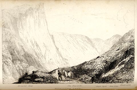 click to enlarge click to enlargeTAT126.jpg The print is captioned with mountain names and acts as an outline view. Tipped in opposite p.73 of The Lakes of England, by George Tattersall. printed at bottom:- "HONISTER CRAG." printed at bottom left to right:- "Honister Crag. / The Haycocks. / High Style. / Red Pike. / Hindscarth." item:- Armitt Library : A1204.27 Image © see bottom of page |
|||||||||||||||||||||||||
|
|
||||||||||||||||||||||||||
| evidence:- | old print:- Rose 1832-35 (vol.2 no.13) placename:- Red Pike |
|||||||||||||||||||||||||
| source data:- | Print, engraving, Loweswater, from Water End, Cumberland, by Thomas Allom, engraved
by W Floyd, 1833.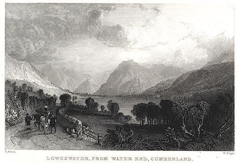 click to enlarge click to enlargePR0402.jpg The text description of the view it 'includes the mountains of Blake Fell, Mellbreak, and Red Pike.' Vol.2 no.13 in Westmorland, Cumberland, Durham and Northumberland Illustrated, with descriptions by Thomas Rose, published by H Fisher, R Fisher, and P Jackson, Newgate, London, about 1835. item:- Dove Cottage : 2008.107.395 Image © see bottom of page |
|||||||||||||||||||||||||
|
|
||||||||||||||||||||||||||
 BVH04.jpg From NW. (taken 17.8.2011) 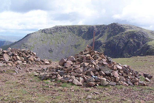 BVH05.jpg Cairn. (taken 17.8.2011) 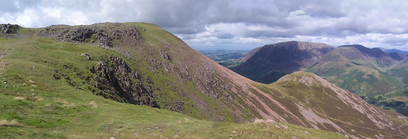 Click to enlarge BVH06.jpg and Dodd, from SE. (taken 17.8.2011) 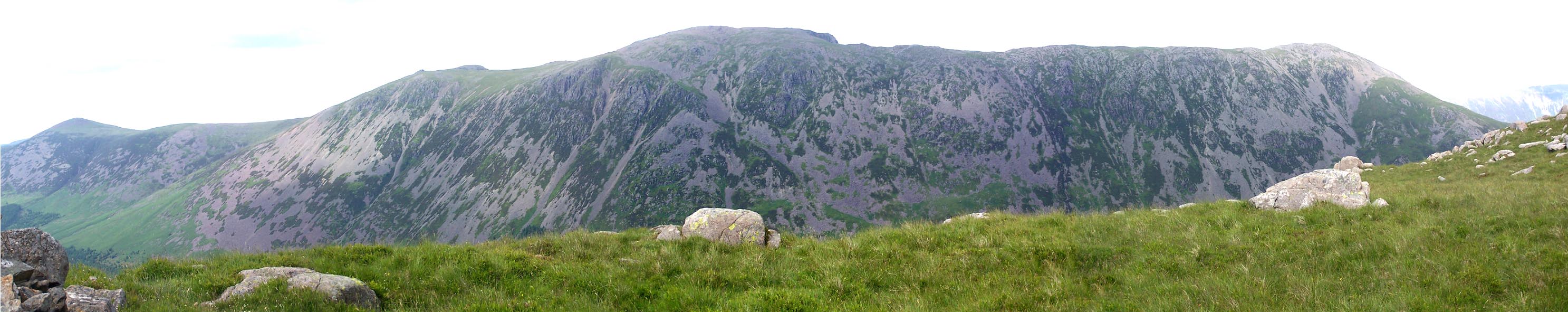 Click to enlarge BQX30.jpg Red Pike, High Stile, High Crag, from Pillar. (taken 25.6.2009) |
||||||||||||||||||||||||||
|
|
||||||||||||||||||||||||||
Lakes Guides menu.