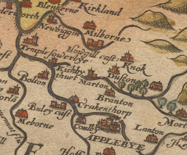
 Saxton 1576 NY62


|

|
|
|
gazetteer links places may or may not be labelled on the map |
||

|
-- Appleby-in-Westmorland -- "APPLEBYE" |
|
|
|
-- Bewley Castle -- "Buley cast:" |
|
|
|
-- Bolton -- "Bolton" |
|
|
|
-- Brampton -- "Branton" |
|
|
|
-- |
|
|
|
-- Colby -- "Coulby" |
|
|
|
-- Crackenthorpe -- "Crakenthorp" |
|
|
|
-- Dufton -- "Duston" |
|
|
|
-- Eden, River -- "Eden flu:" -- "Eden flu:"
-- "Eden flu:" -- "Eden flu:" |
|
|
|
-- |
|
|
|
-- Hoff Beck |
|
|
|
-- Howgill Castle -- "Howgill cast:" |
|
|
|
-- Kirkby Thore -- "Kirkby thuet" |
|
|
|
-- Knock -- "Knok" |
|
|
|
-- Long Marton -- "Marton" |
|
|
|
-- Milburn -- "Milborne" |
|
|
|
-- Newbiggin -- "Newbiggin" |
|
|
|
-- Temple Sowerby -- "Temple sowerbye" |
|
|
|
-- Trout Beck -- "Trout bek" |
|
|
civil parishes The area roughly includes parts of parishes:- Temple Sowerby Cliburn Crackenthorpe Bolton Newbiggin Long Marton Murton Crosby Ravensworth Brougham Dufton Sleagill Kirkby Thore Milburn Newby Culgaith King's Meaburn Morland Appleby-in-Westmorland Colby |
||
|
|
||
|
|
Lakes Guides menu. | |