 Garnett 1850s-60s NY20


|

|
|
|
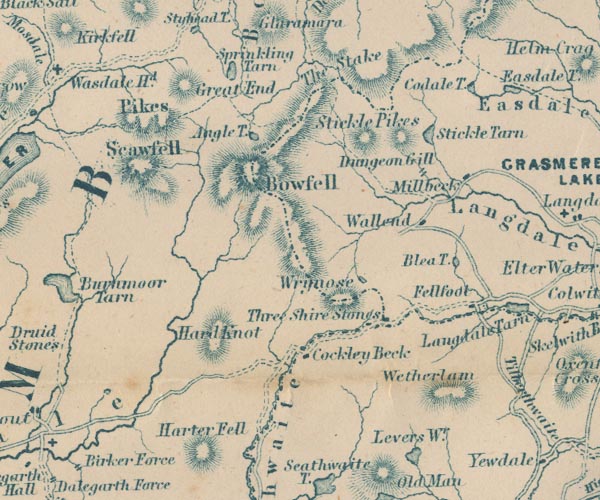
gazetteer links places may or may not be labelled on the map |
||

|
-- Angle Tarn -- "Angle T." |
|
|
|
-- Blea Tarn -- "Blea T." |
|
|
|
-- Bow Fell -- "Bowfell" |
|
|
|
-- Cockley Beck -- "Cockley Beck" |
|
|
|
-- Codale Tarn -- "Coldale T." |
|
|
|
-- Dungeon Ghyll Force -- "Dungeon Gill" |
|
|
|
-- Fell Foot -- "Fellfoot" |
|
|
|
-- Great End -- "Great End" |
|
|
|
-- Hard Knott -- "Hard Knot" |
|
|
|
-- Harter Fell -- "Harter Fell" |
|
|
|
-- Langdale Pikes -- "Stickle Pikes" |
|
|
|
-- Millbeck -- "Millbeck" |
|
|
|
-- Red Tarn |
|
|
|
-- Sca Fell -- "Pikes / Scawfell" |
|
|
|
-- Scafell Pike -- "Pikes / Scawfell" |
|
|
|
-- Sprinkling Tarn -- "Sprinkliing Tarn" |
|
|
|
-- Stake Pass -- "The Stake" |
|
|
|
-- Stickle Tarn -- "Stickle Tarn" |
|
|
|
-- Three Shire Stones -- "Three Shire Stones" |
|
|
|
-- Wall End -- "Wallend" |
|
|
|
-- Wetherlam -- "Wetherlam" |
|
|
|
-- Wrynose Fell -- "Wrynose" |
|
|
civil parishes The area roughly includes parts of parishes:- Dunnerdale-with-Seathwaite Eskdale Lakes Ulpha Nether Wasdale Coniston St John's Castlerigg and Wythburn Borrowdale |
||
|
|
||
|
|
Lakes Guides menu. | |