 Morden 1695 (Wmd) NY51


|

|
|
|
gazetteer links places may or may not be labelled on the map |
||

|
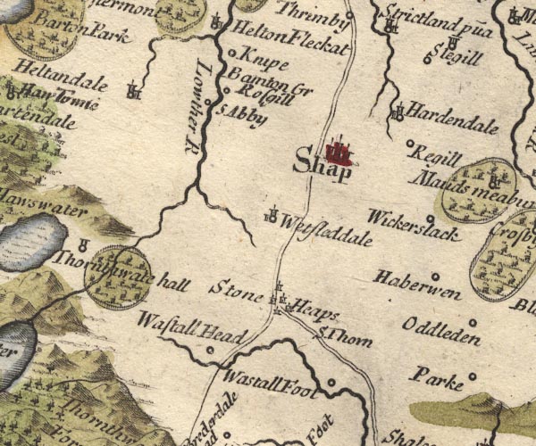
-- Bampton Grange -- "Bamton Gr" |
|
|
|
-- Harberwain -- "Haberwen" |
|
|
|
-- Hardendale -- "Hardendale" |
|
|
|
-- Haweswater Beck |
|
|
|
-- Heltondale -- "Heltondale" |
|
|
|
-- Kemp Howe -- "Stone Heaps" |
|
|
|
-- Knipe Hall -- "Knipe" |
|
|
|
-- Lowther, River -- "Low flu" -- "Lowther
R" |
|
|
|
-- Reagill -- "Regill" |
|
|
|
-- Kendal to Shap |
|
|
|
-- Shap to Penrith |
|
|
|
-- Rosgill -- "Rosgill" |
|
|
|
-- Shap -- "Shap" |
|
|
|
-- Shap Abbey -- "S Abby" |
|
|
|
-- Shap Thorn -- "S. Thorn" |
|
|
|
-- Thornthwaite Hall -- "Thornthwate hall" |
|
|
|
-- Wasdale Foot (?) -- "Wastall Foot" |
|
|
|
-- Wasdale Head -- "Wastall Head" |
|
|
|
-- Wasdale Old Bridge |
|
|
|
-- Wet Sleddale -- "Wetsleddale" |
|
|
|
-- Wickerslack -- "Wickerslack" |
|
|
civil parishes The area roughly includes parts of parishes:- Newby Shap Little Strickland Sleagill Bampton Shap Rural Longsleddale Crosby Ravensworth Thrimby Lowther |
||
|
|
||
|
|
Lakes Guides menu. | |