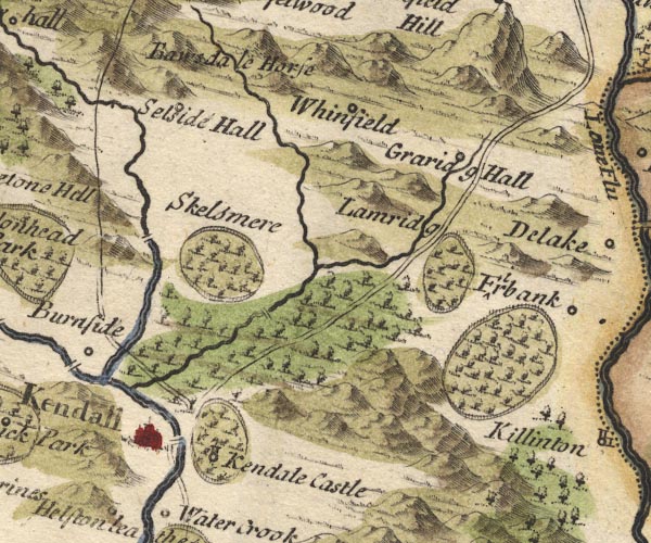
 Morden 1695 (Wmd) SD59


|

|
|
|
gazetteer links places may or may not be labelled on the map |
||

|
-- Bannisdale -- "Ba[w]sdale Horse" |
|
|
|
-- Grayrigg Hall -- "Graridg Hall" |
|
|
|
-- Kendal -- "Kendall" |
|
|
|
-- Kendal Castle -- "Kendale Castle" |
|
|
|
-- Lambrigg Beck (?) |
|
|
|
-- Lambrigg Park -- "Lamridg" |
|
|
|
-- Laverock Bridge |
|
|
|
-- Mint Bridge |
|
|
|
-- Mint, River |
|
|
|
-- Nether Bridge |
|
|
|
-- Old Park |
|
|
|
-- Kendal to Appleby |
|
|
|
-- Kendal to Shap |
|
|
|
-- Selside Hall -- "Selside Hall" |
|
|
|
-- Skelsmergh Hall Farm -- "Skelsmere" |
|
|
|
-- Sprint Bridge |
|
|
|
-- Sprint, River |
|
|
|
-- Stramongate Bridge |
|
|
|
-- Whinfell -- "Whinfield" |
|
|
civil parishes The area roughly includes parts of parishes:- Skelsmergh Scalthwaiterigg Longsleddale Firbank Lambrigg Strickland Roger Docker Kendal Old Hutton and Holmescales Grayrigg Helsington Underbarrow and Bradleyfield Whitwell and Selside Killington Natland New Hutton Strickland Ketel Whinfell |
||
|
|
||
|
|
Lakes Guides menu. | |