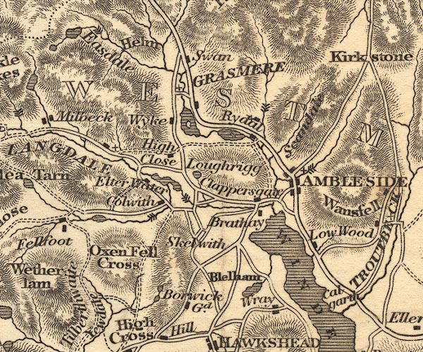
 Otley 1818 NY30


|

|
|
|
gazetteer links places may or may not be labelled on the map |
||

|
-- Ambleside -- "AMBLESIDE" |
|
|
|
-- Blelham Tarn |
|
|
|
-- Borwick Lodge -- "Borwick Gd." |
|
|
|
-- Brathay, River |
|
|
|
-- Calgarth Hall |
|
|
|
-- Chapel Stile |
|
|
|
-- Clappersgate |
|
|
|
-- Colwith Force |
|
|
|
-- Colwith |
|
|
|
-- Easedale Tarn |
|
|
|
-- Easedale |
|
|
|
-- Elter Water |
|
|
|
-- Grasmere |
|
|
|
-- Grasmere -- "GRASMERE" |
|
|
|
-- Helm Crag |
|
|
|
-- High Close |
|
|
|
-- High Fall |
|
|
|
-- Little Langdale Tarn |
|
|
|
-- Loughrigg Fell |
|
|
|
-- Loughrigg Tarn |
|
|
|
-- Low Wood Hotel |
|
|
|
-- Old Brathay |
|
|
|
-- Oxen Fell |
|
|
|
-- Pelter Bridge |
|
|
|
-- Rydal Water |
|
|
|
-- Rydal |
|
|
|
-- Scandale Pass |
|
|
|
-- Skelwith Bridge |
|
|
|
-- Skelwith Force |
|
|
|
-- Stock Ghyll |
|
|
|
-- Stockghyll Force |
|
|
|
-- Swan Hotel |
|
|
|
-- Tarns, The |
|
|
|
-- Tilberthwaite |
|
|
|
-- Wansfell |
|
|
|
-- Windermere lake -- "WINDERMERE" |
|
|
|
-- Wray Castle |
|
|
|
-- Wyke, The |
|
|
|
-- Yewdale |
|
|
civil parishes The area roughly includes parts of parishes:- Claife Lakes Windermere Skelwith Coniston Patterdale |
||
|
|
||
|
|
Lakes Guides menu. | |